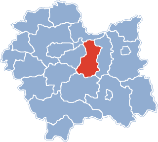
Gmina Rzezawa is a rural gmina in Bochnia County, Lesser Poland Voivodeship, in southern Poland. Its seat is the village of Rzezawa, which lies approximately 6 kilometres (4 mi) east of Bochnia and 43 km (27 mi) east of the regional capital Kraków.
Gmina Szczurowa is a rural gmina in Brzesko County, Lesser Poland Voivodeship, in southern Poland. Its seat is the village of Szczurowa, which lies approximately 17 kilometres (11 mi) north of Brzesko and 52 km (32 mi) east of the regional capital Kraków.

Brzeźnica is a village in the administrative district of Gmina Bochnia, within Bochnia County, Lesser Poland Voivodeship, in southern Poland. It lies approximately 5 kilometres (3 mi) south-east of Bochnia and 40 km (25 mi) east of the regional capital Kraków.

Cikowice is a village in the administrative district of Gmina Bochnia, within Bochnia County, Lesser Poland Voivodeship, in southern Poland. It lies approximately 5 kilometres (3 mi) west of Bochnia and 32 km (20 mi) east of the regional capital Kraków.

Damienice is a village in the administrative district of Gmina Bochnia, within Bochnia County, Lesser Poland Voivodeship, in southern Poland. It lies approximately 3 kilometres (2 mi) west of Bochnia and 35 km (22 mi) east of the regional capital Kraków.
Gorzków is a village in the administrative district of Gmina Bochnia, within Bochnia County, Lesser Poland Voivodeship, in southern Poland. It lies approximately 4 kilometres (2 mi) east of Bochnia and 41 km (25 mi) east of the regional capital Kraków.
Stanisławice is a village in the administrative district of Gmina Bochnia, within Bochnia County, Lesser Poland Voivodeship, in southern Poland. It lies approximately 6 kilometres (4 mi) west of Bochnia and 31 km (19 mi) east of the regional capital Kraków.
Zatoka is a village in the administrative district of Gmina Bochnia, within Bochnia County, Lesser Poland Voivodeship, in southern Poland. It lies approximately 9 kilometres (6 mi) north-east of Bochnia and 42 km (26 mi) east of the regional capital Kraków.
Kobyle is a village in the administrative district of Gmina Nowy Wiśnicz, within Bochnia County, Lesser Poland Voivodeship, in southern Poland. It lies approximately 5 kilometres (3 mi) east of Nowy Wiśnicz, 10 km (6 mi) south-east of Bochnia, and 45 km (28 mi) east of the regional capital Kraków.
Borek is a village in the administrative district of Gmina Rzezawa, within Bochnia County, Lesser Poland Voivodeship, in southern Poland. It lies approximately 4 kilometres (2 mi) north of Rzezawa, 8 km (5 mi) north-east of Bochnia, and 42 km (26 mi) east of the regional capital Kraków.
Bratucice is a village in the administrative district of Gmina Rzezawa, within Bochnia County, Lesser Poland Voivodeship, in southern Poland. It lies approximately 10 kilometres (6 mi) north of Rzezawa, 12 km (7 mi) north-east of Bochnia, and 43 km (27 mi) east of the regional capital Kraków.
Buczków is a village in the administrative district of Gmina Rzezawa, within Bochnia County, Lesser Poland Voivodeship, in southern Poland. It lies approximately 9 kilometres (6 mi) north-east of Rzezawa, 13 km (8 mi) north-east of Bochnia, and 45 km (28 mi) east of the regional capital Kraków.
Dąbrówka is a village in the administrative district of Gmina Rzezawa, within Bochnia County, Lesser Poland Voivodeship, in southern Poland. It lies approximately 9 kilometres (6 mi) north-east of Rzezawa, 13 km (8 mi) north-east of Bochnia, and 45 km (28 mi) east of the regional capital Kraków.
Dębina is a village in the administrative district of Gmina Rzezawa, within Bochnia County, Lesser Poland Voivodeship, in southern Poland. It lies approximately 8 kilometres (5 mi) north of Rzezawa, 11 km (7 mi) north-east of Bochnia, and 43 km (27 mi) east of the regional capital Kraków.
Jodłówka is a village in the administrative district of Gmina Rzezawa, within Bochnia County, Lesser Poland Voivodeship, in southern Poland. It lies approximately 3 kilometres (2 mi) east of Rzezawa, 9 km (6 mi) east of Bochnia, and 45 km (28 mi) east of the regional capital Kraków.
Krzeczów is a village in the administrative district of Gmina Rzezawa, within Bochnia County, Lesser Poland Voivodeship, in southern Poland. It lies approximately 3 kilometres (2 mi) west of Rzezawa, 4 km (2 mi) east of Bochnia, and 40 km (25 mi) east of the regional capital Kraków.
Łazy is a village in the administrative district of Gmina Rzezawa, within Bochnia County, Lesser Poland Voivodeship, in southern Poland. It lies approximately 3 kilometres (2 mi) south-west of Rzezawa, 6 km (4 mi) east of Bochnia, and 42 km (26 mi) east of the regional capital Kraków.
Okulice is a village in the administrative district of Gmina Rzezawa, within Bochnia County, Lesser Poland Voivodeship, in southern Poland. It lies approximately 10 kilometres (6 mi) north of Rzezawa, 12 km (7 mi) north-east of Bochnia, and 43 km (27 mi) east of the regional capital Kraków.
Ostrów Królewski is a village in the administrative district of Gmina Rzezawa, within Bochnia County, Lesser Poland Voivodeship, in southern Poland. It lies approximately 5 kilometres (3 mi) north-west of Rzezawa, 6 km (4 mi) north-east of Bochnia, and 40 km (25 mi) east of the regional capital Kraków.

Berest is a village in the administrative district of Gmina Krynica-Zdrój, within Nowy Sącz County, Lesser Poland Voivodeship, in southern Poland, close to the border with Slovakia. It lies approximately 12 kilometres (7 mi) north of Krynica-Zdrój, 24 km (15 mi) south-east of Nowy Sącz, and 97 km (60 mi) south-east of the regional capital Kraków.