Sogn og Fjordane was a county in western Norway, up to 1 January 2020 when it was merged to become part of Vestland county. Bordering previous counties Møre og Romsdal, Oppland, Buskerud, and Hordaland, the county administration was in the village of Hermansverk in Leikanger municipality. The largest town in the county was Førde.

The Hardangerfjord is the fifth longest fjord in the world, and the second longest fjord in Norway. It is located in Vestland county in the Hardanger region. The fjord stretches 179 kilometres (111 mi) from the Atlantic Ocean into the mountainous interior of Norway along the Hardangervidda plateau. The innermost point of the fjord reaches the town of Odda.

Davik is a former municipality in the traditional district of Nordfjord in the old Sogn og Fjordane county, Norway. The 654-square-kilometre (253 sq mi) former municipality existed from 1838 until 1964 and it encompassed all the lands surrounding the outer part of the large Nordfjorden on both sides of the fjord. Davik was located in parts of the present-day municipalities of Kinn, Bremanger, and Stad. The administrative center of the former municipality was the village of Davik which is located on the southern shore of the Nordfjorden, although some of the municipal services were based out of the village of Bryggja on the north side of the fjord, since that village was the largest village in Davik municipality.
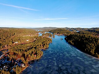
Vegår is a lake in the municipality of Vegårshei in Agder county, Norway. The 17.7-square-kilometre (6.8 sq mi) lake is located about 3 kilometres (1.9 mi) north of the municipal center of Myra and about 12 kilometres (7.5 mi) east of the village of Åmli in the neighboring municipality of Åmli.

Stjernøya (Norwegian) or Stierdná (Northern Sami) is an island in western Finnmark county, Norway. The 248.1-square-kilometre (95.8 sq mi) island sits at the mouth of the Altafjorden on the south side of the Sørøysundet strait. It is divided among the municipalities of Loppa, Hasvik, and Alta.

Bremangerlandet is an island in Bremanger Municipality in the traditional district of Nordfjord in Vestland county, Norway. The 153-square-kilometre (59 sq mi) island is one of the largest islands in the county. The highest point on the island is the 889-metre (2,917 ft) tall mountain Svartevassegga, however the cliff at Hornelen, located 1 kilometre (0.62 mi) to the east, is more well-known and has an elevation of 860 metres (2,820 ft). The 4-kilometre (2.5 mi) long lake Dalevatnet is located in the central part of the island.
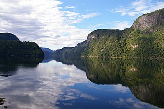
Osterfjorden is a fjord in Vestland county, Norway. The fjord is one of three fjords surrounding the island of Osterøy. The fjord runs along the municipal border of Alver and Osterøy municipalities. The fjord begins at the Romarheimsfjorden and flows to the west for 27 kilometres (17 mi) before ending near the village of Knarvik at the confluence of four fjords: Osterfjorden, Radfjorden, Sørfjorden, and Salhusfjorden. The Osterfjorden is generally about 1 to 3 kilometres wide and the deepest point in the fjord reaches a depth of 639 metres (2,096 ft) below sea level.
Sørfjorden is a 30-kilometre (19 mi) long fjord in Vestland county, Norway. The fjord flows around the west and south sides of the island of Osterøy, going through the municipalities of Osterøy, Bergen, and Vaksdal. The fjord begins at the village of Vaksdal where the Veafjorden flows into the Sørfjorden, it then heads west and then north before emptying into the Osterfjorden. The fjord flows past the following villages: Bruvik, Vaksdal, Hausvik, Garnes, Ytre Arna, Hylkje, Breistein, Valestrandfossen, Steinstø and Hamre.
Nordfjorden is part of Søndeledfjorden in the municipality of Risør in Agder county, Norway. It lies on the north side of the island of Barmen, which is northwest of the town of Risør. Nordfjorden is a little over 7 kilometres (4.3 mi) long. The widest parts are where the Søndeledfjorden goes west and to the village of Søndeled and when the Rødsfjorden joins the Sørfjorden which is on the south side of Barmen island. The south side of the fjord is a relatively straight coastline, but on the north of the fjord there are many coves and bays. The largest of these are Kjødvika and Sivikkilen.

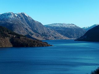
Sørfjorden is a 38-kilometre (24 mi) long fjord that is one of the innermost branches of the main Hardangerfjorden. It is located in Ullensvang Municipality in Vestland county, Norway. It is the longest arm that branches off of the Hardangerfjord. Sørfjorden stretches from just north of the village of Kinsarvik straight south to the industrial town of Odda. The Folgefonna glacier and Folgefonna National Park are located just to the west of the fjord and the Hardangervidda mountain plateau lies to its east.
Salhusfjorden is a 4-kilometer (2.5 mi) long fjord and sound between Bergen Municipality and Alver Municipality in Vestland county, Norway. To the west, it starts between the villages of Salhus and Frekhaug, where the Byfjorden meets the Herdlefjorden. To the east, the fjord ends between the village of Knarvik and the Hordvikneset peninsula, where the Osterfjorden runs northeast, the Sørfjorden runs southeast, and the Radfjorden runs north. The fjord is up to 500 meters (1,600 ft) deep. It acts as one of the borders between the districts of Midhordland to the south and Nordhordland to the north. The islands of Holsnøy and Flatøy lie along the northern side of the fjord.
The Gjegnalundsbreen glacier is located in Vestland county, Norway. The 13-square-kilometre (5.0 sq mi) glacier sits on the borders of the municipalities of Bremanger and Gloppen. The glacier sits on the eastern side of the 1,670-metre (5,480 ft) tall mountain Blånibba, inside the Ålfotbreen landscape protection area which also includes the nearby Ålfotbreen glacier. The Nordfjorden and Hyefjorden are located just north and east of the glacier. The village of Hyen lies about 5 kilometres (3.1 mi) south of the fjord.

Bindalsfjorden is a fjord in the southern part of Nordland county, Norway.

Melfjorden is a fjord in the municipality of Rødøy in Nordland county, Norway. It is located on the Arctic Circle. The 33-kilometre (21 mi) long fjord goes from the village of Melfjordbotn in the east to its mouth in the Rødøyfjorden near the island of Rangsundøya. There are two fjord arms that branch off the main fjord: Nordfjorden flows to the north into the Saltfjellet–Svartisen National Park and Sørfjorden to the south past the villages of Sørfjorden and Kilboghavn.

Ullsfjorden (Norwegian) or Olggosvuotna (Northern Sami) is a fjord in Troms county, Norway. The fjord runs through the municipalities of Tromsø, Karlsøy, and Lyngen. The 75-kilometre (47 mi) fjord flows from the village of Sjøvassbotn northwards along the west side of the Lyngen Peninsula. The Kjosen fjord branches off to the east side and the Grøtsundet strait branches off to the west. The islands of Reinøya and Karlsøya lie along the western side of the fjord. The southern part of the Ullsfjorden is also known as Sørfjorden. The area surrounding the Ullsfjorden was part of Ullsfjord Municipality for about 60 years during the 20th century.

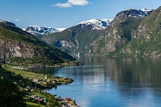
Nordfjorden is the sixth longest fjord in Norway. It flows through the municipalities of Stryn, Gloppen, Stad, Bremanger, and Kinn, and it is the central feature of the entire Nordfjord region which makes up the northern third of the county.

Vågsøy is an island in Kinn Municipality in Vestland county, Norway. The 59.1-square-kilometre (22.8 sq mi) island lies on the northern side of the mouth of the Nordfjorden, the sixth longest fjord in Norway. The Stadlandet peninsula lies to the north of the island, the islands of Silda and Barmøya and the mainland lie to the east of the island, the island of Husevågøy lies to the south, and the open ocean lies to the west. Since the island lies along the open ocean, which can be rough, there are several lighthouses along the coastline of the island including: Hendanes Lighthouse, Kråkenes Lighthouse, and Skongenes Lighthouse. The highest point on the island is the 613-metre (2,011 ft) tall Veten.

Bruvik is a village in Osterøy municipality in Vestland county, Norway. The village is located on the southern shore of the island of Osterøy, along the Sørfjorden. It sits about 13 kilometres (8.1 mi) east of the village of Hausvik and about 3 kilometres (1.9 mi) across the fjord from the village of Vaksdal.
Barmen is an island in Risør municipality in Agder county, Norway. The 9-square-kilometre (3.5 sq mi) island lies in the middle of the Søndeledfjorden, separating the fjord into the Nordfjorden to the north and the Sørfjorden to the south. The island is separated from the mainland by a very narrow channel on the southwest corner of the island where there is a short bridge. The bridge is the only road access to the island. Most of the homes on the island are on the southern and western shores. The island is very hilly and forested.

Stad is a municipality in Vestland county, Norway. It is located in the traditional district of Nordfjord. The municipality includes much of the northern shore of the Nordfjorden as well as the Stad peninsula. The administrative centre of the municipality is the village of Nordfjordeid. Other villages in the municipality include Selje, Barmen, Ervik, Flatraket, Hoddevik, Hoddevika, Håvik, Leikanger, Mogrenda, Stårheim, Haugen, Kjølsdalen, Heggjabygda, and Lote.


