Related Research Articles
Soil science is the study of soil as a natural resource on the surface of the Earth including soil formation, classification and mapping; physical, chemical, biological, and fertility properties of soils; and these properties in relation to the use and management of soils.
Natural Resources Conservation Service (NRCS), formerly known as the Soil Conservation Service (SCS), is an agency of the United States Department of Agriculture (USDA) that provides technical assistance to farmers and other private landowners and managers.
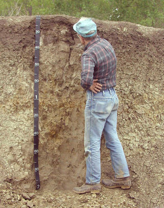
Soil survey, soil mapping, is the process of classifying soil types and other soil properties in a given area and geo-encoding such information. It applies the principles of soil science, and draws heavily from geomorphology, theories of soil formation, physical geography, and analysis of vegetation and land use patterns. Primary data for the soil survey are acquired by field sampling and by remote sensing. Remote sensing principally uses aerial photography, but LiDAR and other digital techniques are steadily gaining in popularity. In the past, a soil scientist would take hard-copies of aerial photography, topo-sheets, and mapping keys into the field with them. Today, a growing number of soil scientists bring a ruggedized tablet computer and GPS into the field with them. The tablet may be loaded with digital aerial photos, LiDAR, topography, soil geodatabases, mapping keys, and more.
Digital soil mapping (DSM) in soil science, also referred to as predictive soil mapping or pedometric mapping, is the computer-assisted production of digital maps of soil types and soil properties. Soil mapping, in general, involves the creation and population of spatial soil information by the use of field and laboratory observational methods coupled with spatial and non-spatial soil inference systems.

Soil map is a geographical representation showing diversity of soil types and/or soil properties in the area of interest. It is typically the end result of a soil survey inventory, i.e. soil survey. Soil maps are most commonly used for land evaluation, spatial planning, agricultural extension, environmental protection and similar projects. Traditional soil maps typically show only general distribution of soils, accompanied by the soil survey report. Many new soil maps are derived using digital soil mapping techniques. Such maps are typically richer in context and show higher spatial detail than traditional soil maps. Soil maps produced using (geo)statistical techniques also include an estimate of the model uncertainty.
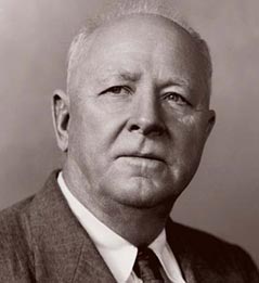
Hugh Hammond Bennett was a pioneer in the field of soil conservation in the United States of America. He was the head of the Soil Conservation Service, a federal agency now referred to as the Natural Resources Conservation Service.

The National Cooperative Soil Survey Program (NCSS) in the United States is a nationwide partnership of federal, regional, state, and local agencies and institutions. This partnership works together to cooperatively investigate, inventory, document, classify, and interpret soils and to disseminate, publish, and promote the use of information about the soils of the United States and its trust territories. The activities of the NCSS are carried out on national, regional, and state levels.
Blom is a European service provider within acquisition, processing and modelling of geographical information. Blom maintains European databases with collections of map, images and models. With particular focus on online services, Blom provides data and services to customers in government, enterprise and consumer markets and enables partners to create applications using Blom’s databases, location-based services and navigation systems. Blom has more than 600 employees and subsidiaries in 10 countries. The company headquarters is in Oslo, Norway. The parent company NRC Group is listed on the Oslo Stock Exchange.

Subaqueous soils are soils formed in sediment found in shallow, permanently flooded environments or soils in any areas permanently covered by water too deep for the growth of rooted plants.
A duripan is a diagnostic soil horizon of the USDA soil taxonomy that is cemented by illuvial silica into a subsurface hardpan. Similar to a fragipan, Petrocalcic Horizon and petrogypsic horizon, it is firmly cemented and restricts soil management. In soil descriptions, they are most often denoted by the symbol Bqm. The closest equivalent in the Canadian system of soil classification is called a duric horizon, although it does not mean exactly the same thing as a duripan in the United States. They form almost exclusively in arid or Mediterranean climates, and can be as hard as concrete, which makes plowing very difficult or impossible. Soils that include duripans are generally used for grazing or wildlife habitat, and are seldom cultivated.

The Great Balsam Mountains, or Balsam Mountains, are in the mountain region of western North Carolina, United States. The Great Balsams are a subrange of the Blue Ridge Mountains, which in turn are a part of the Appalachian Mountains. The most famous peak in the Great Balsam range is Cold Mountain, which is the centerpiece of author Charles Frazier's bestselling novel Cold Mountain.
Pedodiversity is the variation of soil properties within an area. Pedodiversity studies were first started by analyzing soil series–area relationships. According to Guo et al. (2003) the term pedodiversity was developed by McBratney (1992) who discussed landscape preservation strategies based on pedodiversity. Recently, examinations of pedodiversity using indices commonly used to characterize bio-diversity have been made. Ibáñez et al. (1995) first introduced ecological diversity indices as measures of pedodiversity. They include species richness, relative species abundance, and Shannon index. Richness is the number of different soil types, which is the number of soil classes at particular level in a taxonomic system. Abundance is defined as the distribution of the number of soil individuals.

The geography of Iowa includes the study of bedrock, landforms, rivers, geology, paleontology and urbanisation of the U.S. state of Iowa. The state covers an area of 56,272.81 sq mi (145,746 km2).

Newcomer Glacier is a glacier 20 nautical miles long transecting the north part of the Sentinel Range, flowing from the vicinity of Allen Peak southeast between Gromshin Heights and the main ridge of range, and then east between Gromshin Heights and Sostra Heights to where it leaves the Sentinel Range north of Bracken Peak and south of Foros Spur. Named by the Advisory Committee on Antarctic Names (US-ACAN) for Commander Loyd E. Newcomer of U.S. Navy Squadron VX-6, pilot on photographic flights over the range on December 14–15, 1959.
The Indian Institute of Spices Research (IISR) is an autonomous organization engaged in agricultural research related to spices in India. The institute has its headquarters in Moozhikkal, Silver Hills, Kozhikode, Kerala and is a subsidiary of Indian Council of Agricultural Research (ICAR), New Delhi, under the Ministry of Agriculture, India.
Ardilla is an unincorporated community in Houston County, Alabama, United States. Ardilla is located along Alabama State Route 53, 1 mile southeast of Ross Clark Circle in Dothan.
Lucy is an unincorporated community in Houston County, Alabama, United States.
Wicksburg, also spelled Wicksburgh, is an unincorporated community in Houston County, Alabama, United States. Wicksburg is located along Alabama State Route 103, 13.5 miles (21.7 km) west of Dothan.
New Salem is an unincorporated community in Redbank Township, Armstrong County, Pennsylvania, United States. It has also been known as Salem. The community is 24.1 miles (38.8 km) northeast of Kittanning and 7.1 miles (11.4 km) east of New Bethlehem.
McGregor is an unincorporated community in Redbank Township, Armstrong County, Pennsylvania, United States. The community lies along PA-839 at the junction with Porter Rd.
References
- ↑ "Soil Survey Geographic database". NOAA – Office of Coastal Management. Retrieved 2019-01-22.