Saamsky District

Last updated

Saamsky District (Russian : Саамский район) was an administrative division (a district) of Murmansk Okrug of Leningrad Oblast, and later of Murmansk Oblast, of the Russian SFSR, Soviet Union, which existed in 1927–1963.

Russian language East Slavic language

Russian is an East Slavic language, which is official in the Russian Federation, Belarus, Kazakhstan and Kyrgyzstan, as well as being widely used throughout Eastern Europe, the Baltic states, the Caucasus and Central Asia. It was the de facto language of the Soviet Union until its dissolution on 25 December 1991. Although, nowadays, over two decades after the breakup of the Soviet Union, Russian is used in official capacity or in public life in all the post-Soviet nation-states, as well as in Israel and Mongolia, the rise of state-specific varieties of this language tends to be strongly denied in Russia, in line with the Russian World ideology.

A raion is a type of administrative unit of several post-Soviet states. The term is from the French "rayon", which is both a type of a subnational entity and a division of a city, and is commonly translated in English as "district".

Murmansk Okrug was an administrative division of the Russian SFSR, Soviet Union, which existed in 1927–1938.

Contents

It was established as Ponoysky District (Понойский район) on August 1, 1927, when the All-Russian Central Executive Committee issued two Resolutions: "On the Establishment of Leningrad Oblast" and "On the Borders and Composition of the Okrugs of Leningrad Oblast". [1] According to these resolutions, Murmansk Governorate was transformed into Murmansk Okrug, which was divided into six districts (Ponoysky being one of them) and included into Leningrad Oblast. [1] The administrative center of the district was in the selo of Ponoy. [1]

All-Russian Central Executive Committee

The All-Russian Central Executive Committee, was the highest legislative, administrative, and revising body of the Russian Soviet Federative Socialist Republic from 1917 until 1937. Although the All-Russian Congress of Soviets had supreme authority, in periods between its sessions its powers were passed to VTsIK.

Murmansk Governorate was an administrative division of the early Russian SFSR which existed in 1921–1927. The governorate was established on the territory of former Alexandrovsky Uyezd of Arkhangelsk Governorate by the All-Russian Central Executive Committee (VTsIK) Decree issued on June 13, 1921. The administrative center was in Murmansk.

Leningrad Oblast First-level administrative division of Russia

Leningrad Oblast is a federal subject of Russia. It was established on August 1, 1927, although it was not until 1946 that the oblast's borders had been mostly settled in their present position. The oblast was named after the city of Leningrad. Unlike the city, the oblast retains the name of Leningrad.

In 1934, the Murmansk Okrug Executive Committee developed a redistricting proposal, which was approved by the Resolution of the 4th Plenary Session of the Murmansk Okrug Committee of the VKP(b) on December 28-29, 1934 and by the Resolution of the Presidium of the Murmansk Okrug Executive Committee on February 2, 1935. [2] On February 15, 1935, the VTsIK approved the redistricting of the okrug into seven districts, although it did not specify what territories the new districts were to include. [2] On February 26, 1935, the Presidium of the Leningrad Oblast Executive Committee worked out the details of the new district scheme and issued a resolution, which, among other things, renamed the district Saamsky and moved its administrative center to Iokanga. [2] Additionally, Chalmny-Varrsky and Semiostrovsky Selsoviets of Lovozersky District, as well as the settlement of Drozdovka of Teribersky District, were transferred to Saamsky District. [2] On June 1, 1936, the renaming of the district and the administrative center move were approved by the Resolution of the VTsIK. [2]

Communist Party of the Soviet Union political party founded in 1912

The Communist Party of the Soviet Union (CPSU) was the founding and ruling political party of the Soviet Union. The CPSU was the sole governing party of the Soviet Union until 1990, when the Congress of People's Deputies modified Article 6 of the most recent 1977 Soviet constitution, which had granted the CPSU a monopoly over the political system.

Lovozersky District District in Murmansk Oblast, Russia

Lovozersky District is an administrative district (raion), one of the six in Murmansk Oblast, Russia. Municipally, it is incorporated as Lovozersky Municipal District. It occupies most of the central and northeastern parts of the Kola Peninsula. The area of the district is 53,800 square kilometers (20,800 sq mi). Its administrative center is the rural locality of Lovozero. District's population: 11,820 (2010 Census); 14,311 (2002 Census); 18,263 (1989 Census). The population of Lovozero accounts for 24.3% of the district's total population.

Drozdovka is the name of several rural localities in Russia.

Iokanga, the administrative center of the district at the time, comprised de facto two separate inhabited localities, located within 12 kilometers (7.5 mi) from one another—Iokanga proper and Iokangskaya baza, with the district executive committee quarters being located in the latter. [2] In 1936, Iokangskaya baza was renamed Gremikha, but Iokanga continued to be listed as the administrative center of Saamsky District until February 1938. [2]

Ostrovnoy, Murmansk Oblast Town in Murmansk Oblast, Russia

Ostrovnoy, previously known as Murmansk-140 (Му́рманск-140), is a closed town in Murmansk Oblast, Russia. As of the 2010 Census, its population was 2,171; down from 5,032 recorded in the 2002 Census.

Chalmny-Varrsky selsoviet did not remain in Saamsky District for long—the VTsIK Resolution of September 10, 1937 transferred it back to Lovozersky District. [2]

Saamsky District was abolished on January 26, 1963 by the Decision of the Murmansk Oblast Executive Committee. [3] The district's selsoviets were transferred to Lovozersky District, while Gremikha, the administrative center of the former district, was subordinated to Severomorsk. [3]

Severomorsk Town in Murmansk Oblast, Russia

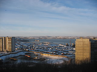
Severomorsk, previously known as Vayenga (Ваенга), is a closed town in Murmansk Oblast, Russia. Severomorsk is the main administrative base of the Russian Northern Fleet. The town is located on the coast of the Barents Sea along the Kola Bay 25 kilometers (16 mi) northeast of Murmansk, the administrative centre of the oblast, to which it is connected by railway and a motorway.

Related Research Articles

Polyarny, Murmansk Oblast Town in Murmansk Oblast, Russia

Polyarny is a town and the administrative center of the closed administrative-territorial formation of Alexandrovsk in Murmansk Oblast, Russia, situated on the outermost western side of the Kola Bay. Population: 17,293 (2010 Census); 18,552 (2002 Census); 27,635 (1989 Census).

Karelian Autonomous Soviet Socialist Republic geographical object

The Karelian Autonomous Soviet Socialist Republic, or, in short, the Karelian ASSR, sometimes referred to as Soviet Karelia or simply Karelia was an autonomous republic of the Russian SFSR, Soviet Union, with the capital in Petrozavodsk.

Monchegorsk Town in Murmansk Oblast, Russia

Monchegorsk is a town in Murmansk Oblast, Russia, located on the Kola Peninsula, 145 kilometers (90 mi) south of Murmansk, the administrative center of the oblast. Population: 45,361 (2010 Census); 52,242 ; 68,652.

Murmansk Oblast is a federal subject of Russia, which is located in the northwestern part of the country, occupying mostly the Kola Peninsula. The oblast itself was established on May 28, 1938, but some kind of administrative organization of the territory existed here since at least the 13th century. As of the 2002 Census, Russians account for the majority of the oblast's population, with the indigenous Sami constituting only a 0.20% minority (1,769 people).

Kola, Russia Town in Murmansk Oblast, Russia

Kola is a town and the administrative center of Kolsky District of Murmansk Oblast, Russia, located at the confluence of the Kola and Tuloma Rivers, 12 kilometers (7.5 mi) south of Murmansk and 24 kilometers (15 mi) southwest of Severomorsk. It is the oldest town of the Kola Peninsula. Population: 10,437 (2010 Census); 11,060 ; 16,541 (1989 Census).

Zasheyek, Murmansk Oblast Inhabited locality in Murmansk Oblast, Russia

Zasheyek is a rural locality in administrative jurisdiction of Polyarnye Zori Town with Jurisdictional Territory in Murmansk Oblast, Russia, located beyond the Arctic Circle on the Kola Peninsula at a height of 142 meters (466 ft) above sea level. Population: 901.

Drozdovka, Murmansk Oblast Place in Murmansk Oblast, Russia

Drozdovka was a rural locality in administrative jurisdiction of the closed administrative-territorial formation of Ostrovnoy in Murmansk Oblast, Russia, located on the Kola Peninsula beyond the Arctic Circle at the elevation of 1 meter above sea level.

Sayda-Guba Inhabited locality in Murmansk Oblast, Russia

Sayda-Guba, also known in English as Sayda Bay, is a rural locality within the administrative jurisdiction of the closed administrative-territorial formation of Alexandrovsk in Murmansk Oblast, Russia, located beyond the Arctic Circle at a height of 10 meters (33 ft) above sea level. As of the 2010 Census, it had no recorded population.

Kolsky District District in Murmansk Oblast, Russia

Kolsky District is an administrative district (raion), one of the six in Murmansk Oblast, Russia. As a municipal division, it is incorporated as Kolsky Municipal District. It is located in the northwest of the oblast, partially lies on the Kola Peninsula, and borders with the Barents Sea in the north and Finland in the west. The area of the district is 27,600 square kilometers (10,700 sq mi). Its administrative center is the town of Kola. Population: 44,670 (2010 Census); 51,125 (2002 Census); 73,555 (1989 Census). The population of Kola accounts for 23.4% of the district's total population.

Tersky District, Murmansk Oblast District in Murmansk Oblast, Russia

Tersky District is an administrative district (raion), one of the six in Murmansk Oblast, Russia. Municipally, it is incorporated as Tersky Municipal District. It is located in the south of the Kola Peninsula and borders the White Sea in the south. The area of the district is 19,300 square kilometers (7,500 sq mi). Its administrative center is the urban locality of Umba. District's population: 6,288 (2010 Census); 7,434 (2002 Census); 9,752 (1989 Census). The population of Umba accounts for 88.0% of the district's total population.

Kolsko-Loparskaya Volost was at various times an administrative division of Kemsky, Kolsky, and Alexandrovsky Uyezds of Arkhangelsk Governorate of the Russian Empire, and then of Murmansk Governorate of the Russian SFSR. It existed in 1868–1927.

Novozerskaya Volost was an administrative division of Alexandrovsky (Murmansky) Uyezd of Arkhangelsk Governorate and then of Murmansk Governorate of the Russian SFSR.

Monchegorsky District was an administrative division of Murmansk Okrug of Leningrad Oblast, and later of Murmansk Oblast of the Russian SFSR, Soviet Union, which existed in 1938–1949.

Kirovsky District was an administrative division of Murmansk Okrug of Leningrad Oblast, and later a district of Murmansk Oblast, of the Russian SFSR, Soviet Union, which existed in 1935–1954.

Polyarny District was an administrative division of Murmansk Okrug of Leningrad Oblast of the Russian SFSR, Soviet Union, and later of Murmansk Oblast, which existed in 1927–1960.

Teribersky District, also known as Severomorsky District was an administrative division of Murmansk Okrug of Leningrad Oblast of the Russian SFSR, Soviet Union, and later of Murmansk Oblast, which existed in 1927–1963.

Kandalakshsky District District in Murmansk Oblast, Russia

Kandalakshsky District is an administrative district, one of the six in Murmansk Oblast, Russia. As a municipal division, it is incorporated as Kandalakshsky Municipal District. It is located in the southwest of the oblast, and borders with Kovdorsky District to the north, Loukhsky District of the Republic of Karelia, and with Finland to the west. The area of the district is 14,400 square kilometers (5,600 sq mi). Its administrative center is the town of Kandalaksha. Population: 49,544 (2010 Census); 60,140 (2002 Census); 78,239 (1989 Census). The population of Kandalaksha accounts for 72.0% of the district's total population.

References

Notes

  1. 1 2 3 Administrative-Territorial Division of Murmansk Oblast, pp. 34-35
  2. 1 2 3 4 5 6 7 8 Administrative-Territorial Division of Murmansk Oblast, pp. 47–49
  3. 1 2 Administrative-Territorial Division of Murmansk Oblast, p. 56

Sources