Sackville Ward

Last updated

The Sackville Ward is a large residential precinct in the suburb of Kew in Melbourne, Australia.

Contents

The Sackville Ward was an electoral ward a part of the City of Kew.

Geography

Bounded to the east by Burke Road to the north by Cotham Road (Maroondah Highway) and to the south by Barkers Road, its western boundary is technically Glenferrie Road but more often deemed to be east of Edgevale or even Davis Streets. The Ward takes its name from the broad east–west avenue running through its centre.

History

Land in the area was purchased during the mid-1840s Government land sales by developers, two of whom were Edward Dumaresq and Peter Davis. Dumaresq (a Captain in the East India Company and one-time Surveyor General of Tasmania, [1] then Van Diemen's Land) subsequently named some of the streets in the area after his sons, Rowland, Edward, John, Alfred and Thomas. [2]

In the resultant economic boom created by the Victorian gold rush, many grand mansions were constructed in the ward, most of which remain to this day. Dumaresq himself lived in Alfred Street and helped develop St Hilary’s Church of England, opening in 1889 and rebuilt in 1939. A brick house at 34 Rowland Street was constructed in 1890 to serve as the vicarage.

There was further development when land adjacent to the Kew Reservoir (near the corner of Burke and Cotham Roads) was subdivided in the early twentieth century, and this area is home to some fine examples of Edwardian and Federation architecture.

Sackville Ward was created as a ward of the City of Kew in 1988, being put forward as a ward name by then sitting councillor, Philip Barnes. This occurred as a result of the reduction from 15 councillors representing the whole of Kew to 12 councillors, and a reduction from 5 wards to 4 wards with 3 councillors representing each ward. Sackville Ward included the previously named College Ward and adjacent areas. After the 1994 council amalgamations, council functions are now administered by the City of Boroondara.

Today

The ward is now sought-after due to its proximity to reputable private schools such as Carey Baptist Grammar School (1923), Methodist Ladies' College (1882), Ruyton Girls' School (1879), Trinity Grammar School (1902), Genazzano FCJ College (1889), Xavier College (1878) and the alternative education school Preshil. [3]

In August 2008 an IT executive paid more than $12 million in an off-market sale for La Verna, a 120-year-old mansion built in the Italianate style. The sale was the highest in value for Melbourne for the year to date and created at the time, a new record for Kew. [4]

The La Verna sale was for a property much reduced in size. Controversially, what had previously been a Catholic monastery and retreat for Franciscan Friars with 1.2 hectare gardens and stables was sold by the Church in 2002 to developer Phillip Watts for $8.3 million. In February 2004 150 local residents lobbied the Booroondarra Council in an attempt to save the gardens of the estate by attempting to create a site-specific heritage overlay. [5]

At that time the estate also had a significant frontage to leafy Rowland Street. The remaining land was however subdivided into seven large blocks and all have since been developed with large residential dwellings. What were originally the stables for the property (also fronting Rowland Street) have now been sympathetically developed into a coachouse-style accommodation. Photographs of the La Verna development can be found on the Walking Melbourne website dedicated to discovering and protecting Melbourne's mansions. [6]

Prior to the La Verna sale, the previous record had been $6.6 million at auction for 19 Grange Road Kew to businessman and politician Evan Thornley and his wife Tracey Ellery (founders of internet company LookSmart). Thornley is now an ALP member of the Upper House in the Victorian State Government and the property has been extensively redeveloped. [7]

In spite of the global economic crisis of the time, Kew as a whole recorded a 44.8% increase in median values for the year to 31 July 2008 (to $1.495million) buoyed largely by sales in the Sackville Ward. [3] The exclusive nature of the ward notwithstanding, there are a number of facilities within the area aimed at the elderly and the homeless. Prague House in Sackville Street is operated by the Sisters of Charity caters for homeless men and was redeveloped in 2006 using both funds from the Federal Department of Health and Ageing and donors (who contributed $200,000 for furniture and fittings). [8] The Yarralee Residential Aged Care Facility is located at 48 Sackville Street.

Related Research Articles

<span class="mw-page-title-main">City of Boroondara</span> Local government area in Victoria, Australia

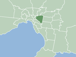
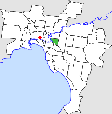
The City of Boroondara is a local government area in Victoria, Australia. It is located in the eastern suburbs of Melbourne. It was formed in June 1994 from the amalgamation of the Cities of Kew, Camberwell and Hawthorn.

<span class="mw-page-title-main">City of Darebin</span> Local government area in Victoria, Australia

The City of Darebin is a local government area in Victoria, Australia, in the northern suburbs of Melbourne. It has an area of 54 square kilometres (20.8 sq mi) and in June 2018 Darebin had a population of 161,609. Municipal offices are located at 350 High Street, Preston.

<span class="mw-page-title-main">Middle Park, Victoria</span> Suburb of Melbourne, Victoria, Australia

Middle Park is an inner suburb in Melbourne, Victoria, Australia, 5 km south of Melbourne's Central Business District, located within the City of Port Phillip local government area. Middle Park recorded a population of 4,000 at the 2021 census.

<span class="mw-page-title-main">Balwyn</span> Suburb of Melbourne, Victoria, Australia

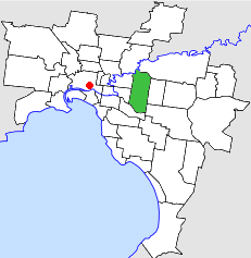
Balwyn is a suburb of Melbourne, Victoria, Australia, 10 km east of Melbourne's Central Business District, located within the City of Boroondara local government area. Balwyn recorded a population of 13,495 at the 2021 census.

<span class="mw-page-title-main">Balwyn North</span> Suburb of Melbourne, Victoria, Australia

Balwyn North, also known as North Balwyn, is a suburb of Melbourne, Victoria, Australia, 10 km east of Melbourne's Central Business District, located within the Cities of Boroondara and Whitehorse local government areas. Balwyn North recorded a population of 21,302 at the 2021 census.

<span class="mw-page-title-main">Hawthorn, Victoria</span> Suburb of Melbourne, Victoria, Australia

Hawthorn is an inner suburb of Melbourne, Victoria, Australia, 6 kilometres (3.7 mi) east of Melbourne's central business district, located within the City of Boroondara local government area. Hawthorn recorded a population of 22,322 at the 2021 census.

<span class="mw-page-title-main">Kew, Victoria</span> Suburb of Melbourne, Victoria, Australia

Kew (;) is a suburb of Melbourne, Victoria, Australia, 5 km east from Melbourne's Central Business District, located within the City of Boroondara local government area. Kew recorded a population of 24,499 at the 2021 census.

<span class="mw-page-title-main">Bundoora</span> Suburb of Melbourne, Victoria, Australia

Bundoora is a suburb in Melbourne, Victoria, Australia, 15 km (9.3 mi) north-east of Melbourne's Central Business District, located within the Cities of Banyule, Darebin and Whittlesea local government areas. Bundoora recorded a population of 28,068 at the 2021 census.

<span class="mw-page-title-main">Footscray, Victoria</span> Suburb of Melbourne, Victoria, Australia

Footscray is an inner-city suburb in Melbourne, Victoria, Australia, 5 km (3.1 mi) west of Melbourne's Central Business District, located within the City of Maribyrnong local government area. Footscray recorded a population of 17,131 at the 2021 census.

<span class="mw-page-title-main">Thornley, Durham</span> Human settlement in England

Thornley is a village in County Durham, in England. It is situated about 5 miles (9 km) to the east of Durham and 5 miles (7 km) west of Peterlee. Thornley is part of the Sedgefield parliamentary constituency of which Tony Blair was the Member of Parliament from 1983 until 2007.

<span class="mw-page-title-main">Redland, Bristol</span> Human settlement in England

Redland is a neighbourhood in Bristol, England. The neighbourhood is situated between Clifton, Cotham, Bishopston and Westbury Park. The boundaries of the district are not precisely defined, but are generally taken to be Whiteladies Road in the west, the Severn Beach railway line in the south and Cranbrook Road in the east.

<span class="mw-page-title-main">Melbourne tram route 48</span>

Melbourne tram route 48 is operated by Yarra Trams on the Melbourne tram network from Balwyn North to Victoria Harbour. The 13.5-kilometre (8.4 mi) route is operated out of Kew depot with A and C class trams.

<span class="mw-page-title-main">Macleod, Victoria</span> Suburb of Melbourne, Victoria, Australia

Macleod is a suburb in Melbourne, Victoria, Australia, 14 km (8.7 mi) north-east of Melbourne's Central Business District, located within the Cities of Banyule and Darebin local government areas. Macleod recorded a population of 9,892 at the 2021 census.

<span class="mw-page-title-main">City of Kew</span> Local government area in Victoria, Australia

The City of Kew was a local government area about 4 kilometres (2.5 mi) east of Melbourne, the state capital of Victoria, Australia, on the southeast bank of the Yarra River. The city covered an area of 14.56 square kilometres (5.62 sq mi), and existed from 1860 until 1994.

<span class="mw-page-title-main">City of Hawthorn</span> Local government area in Victoria, Australia

The City of Hawthorn was a local government area about 4 kilometres (2.5 mi) east of Melbourne, the state capital of Victoria, Australia, on the southeast bank of the Yarra River. The city covered an area of 9.71 square kilometres (3.75 sq mi), and existed from 1860 until 1994.

<span class="mw-page-title-main">City of Camberwell</span> Local government area in Victoria, Australia

The City of Camberwell was a local government area about 10 kilometres (6 mi) east of Melbourne, the state capital of Victoria, Australia. The city covered an area of 36.01 square kilometres (13.90 sq mi), and existed from 1914 until 1994.

<span class="mw-page-title-main">Bike paths in Melbourne</span> Cycling routes and cycling lanes in Melbourne, Australia

Bike paths around Melbourne have been developed over many decades. Many off-road trails follow current or former watercourses, such as the Darebin Creek Trail and the Koonung Creek Trail and traverse long distances, meaning that responsibility for planning and maintenance is split between various State Government authorities and local councils. With the increased recognition from all levels of government of the benefit of cycling activities, Melbourne today has a network of shared bicycle trails which have developed over time along its river and creek systems and alongside freeways and railways.

Edward Dumaresq was a landowner, magistrate and acted as Surveyor General of Van Diemen's Land.

Glass Creek is a waterway flowing through the inner-eastern suburbs of Melbourne. It is a minor tributary of the Yarra River and now largely runs through a series of underground drains.

Hays Paddock is a popular Australian recreational park in the eastern Melbourne suburb of Kew East. Managed by City of Boroondara council, the park consists of a popular playground, walking & cycling tracks, and two ovals for teams playing Archery, Cricket, and Soccer. The park is also sometimes referred to as 'Kilby Park' due to its proximity to Kilby Road, and 'Glass Creek' due to the creek of the same name that passes through.

References

  1. Page, Roger (1966). "Dumaresq, Edward (1802–1906)". Australian Dictionary of Biography . National Centre of Biography, Australian National University. ISSN   1833-7538 . Retrieved 18 June 2012.
  2. "Kew — City of Kew Urban Conservation Study:Volume 2" (PDF). p. 16. Retrieved 18 June 2012.
  3. 1 2 Melbourne's Best Performing Suburbs This Year. http://www.realestatesource.com.au/index2.php?option=com_content&do_pdf=1&id=1268
  4. RealEstateSource.com.au 27 August 2008. http://www.realestatesource.com.au/Victoria/New-House-Price-Record-Set-in-Kew.html
  5. The Age, 5 February 2004. http://www.theage.com.au/articles/2004/02/04/1075853937228.html?from=storyrhs
  6. Walking Melbourne. Discarding History to Make Money. http://www.walkingmelbourne.com/forum/viewtopic.php?t=695
  7. RealEstateSource.com.au, 25 November 2007. http://www.realestatesource.com.au/Victoria/Looksmart-Founder-Turned-ALP-Member-Smashes-Record-for-Kew-House.html
  8. Prague House: New housing for homeless people opens in Kew. http://www.dhs.vic.gov.au/humanservicesnews/oct06/kew.htm

Further reading