
Sacombe Green is a hamlet located to the east of the village of Sacombe, in the East Hertfordshire district, in the county of Hertfordshire, England.
Sacombe Green is a hamlet located to the east of the village of Sacombe, in the East Hertfordshire district, in the county of Hertfordshire, England.
51°51′33″N0°03′09″W / 51.8592°N 0.0526°W
| | This Hertfordshire location article is a stub. You can help Wikipedia by expanding it. |
BBC Three Counties Radio is the BBC's local radio station serving the counties of Bedfordshire, Hertfordshire and Buckinghamshire.

The Diocese of St Albans forms part of the Province of Canterbury in England and is part of the wider Church of England, in turn part of the worldwide Anglican Communion.
Lee Valley Regional Park is a 10,000-acre (40 km2) 26 miles (42 km) long linear park, much of it green spaces, running through the northeast of Greater London, Essex and Hertfordshire. The park follows the course of the River Lea (Lee) along the Lea Valley from Ware in Hertfordshire through Essex and the north east of Greater London, through the Queen Elizabeth Olympic Park to East India Docks Basin on the River Thames. The park is managed by Lee Valley Regional Park Authority and is made up of a diverse mix of countryside areas, urban green spaces, heritage sites, country parks, nature reserves and lakes and riverside trails, as well as leading sports centres covering an area of over 10,000 acres (40 km2). It is crossed by a number of roads and railways.
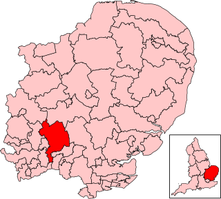
North East Hertfordshire is a constituency represented in the House of Commons of the UK Parliament since 2024 by Chris Hinchliff of the Labour Party.

Ardeley is a small village and civil parish in East Hertfordshire, England. The parish includes the hamlet of Cromer, as well as Wood End and Moor Green.
Bayford is a village and civil parish in the East Hertfordshire district of Hertfordshire, England. According to the 2001 census it had a population of 435, increasing to 466 at the 2011 Census. The village is about three miles south of Hertford, and is served by Bayford railway station.

Heath Mount School is a Church of England co-educational independent prep school near Watton-at-Stone, Hertfordshire, England. It admits pupils aged 3 to 13. It was founded as Heath Mount Academy in Hampstead in 1796. In 1934 it was relocated to a Georgian mansion on the Woodhall Estate in rural Hertfordshire. For the 2022 academic year, 498 students were enrolled: boarding pupils and day pupils and girls and boys.

Hitchin is a parliamentary constituency in Hertfordshire and Bedfordshire which returned one Member of Parliament (MP) to the House of Commons of the Parliament of the United Kingdom from 1885 until it was abolished for the 1983 general election.
The A602 is a road linking Hitchin in Hertfordshire, England, with A10 at Ware in Hertfordshire, via Stevenage.

The A405 is a 4.8 miles dual carriageway road in Hertfordshire, England, from the A41 at Leavesden Green, near Watford, to the A414 at Park Street Roundabout near St Albans.
Sir Thomas Rolt (c.1631–1710) was a British official of the East India Company, President of Surat and Governor of Bombay from 1677 to 1681. His father was Edward Rolt of Pertenhall in Bedfordshire; his mother was Edward Rolt's second wife Mary, a daughter of Sir Oliver Cromwell.
Commercial Dock was a railway station in Rotherhithe, south-east London, on the London and Greenwich Railway. It was situated on approximately the same site as the later Southwark Park railway station. Numerous sources disagree over when Commercial Dock station was opened, with July 1856, 1859, or 1867 being possibilities; it closed in 1867. No visible trace of the station remains.

Great Munden is a village and civil parish in Hertfordshire, England. The parish, in the district of East Hertfordshire, spans 3,758 acres (5.872 sq mi), of which 1,895.75 acres (2.96211 sq mi) are arable land, 927.5 acres (1.4492 sq mi) are permanent grass and 97 acres (0.152 sq mi) are wood. It has a population of 477, reducing to 339 at the 2011 Census, and is situated 6 miles (9.7 km) north of the town of Ware. The village includes the church of St Nicholas, Munden Bury, and a rectory that includes the remains of a moat. Other settlements in the parish include Nasty and Levens Green. A detached portion of Little Munden was added to the parish in 1888.
Sacombe is a village and civil parish in the East Hertfordshire district, of Hertfordshire, England. At the 2001 census it had a population of 165. Sacombe is located about 4 miles N N W of Ware; other nearby settlements include Dane End and Sacombe Green.

Moor Hall Meadows is a 24.4-hectare (60-acre) biological Site of Special Scientific Interest in Moor Green in Hertfordshire. The local planning authority is East Hertfordshire District Council.

Blagrove Common is a 4.0-hectare (9.9-acre) Site of Special Scientific Interest in Green End near Sandon in Hertfordshire. It is managed by the Hertfordshire and Middlesex Wildlife Trust, and the planning authority is North Hertfordshire District Council.

St John's Church, Letty Green, is a deconsecrated Gothic Revival church in Letty Green, Hertfordshire, England.

The Green Man is a grade II listed public house in Mill Green Lane, Hatfield, Hertfordshire, England. The building is based on a seventeenth-century timber frame with later additions.

The White Horse is a grade II listed public house in Whitehorse Lane, Burnham Green, in the parish of Datchworth in Hertfordshire. The building dates from around the seventeenth century. It was formerly known as The Chequers.