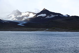
Sacramento Bight is an open bight, 2.5 miles (4.0km) wide, between Calf Head and Cape Harcourt on the north coast of South Georgia. The name "Pinguin-Bay" was given by the German group of the International Polar Year Investigations, 1882–83, to a small bay within the bight now described. The SGS, 1951–52, reported that a name is not necessary for this bay, and that the bight, which is known to whalers and sealers as Sacramento Bay, does require a name. In order to indicate the correct nature of the feature, and at the same time to conform to local usage, the name Sacramento Bight is approved.
In geography, a bight is a bend or curve in a coastline, river, or other geographical feature. It typically indicates a large, open bay, often only slightly receding. It is distinguished from a sound by being shallower. Traditionally, explorers defined a bight as a bay that could be sailed out of on a single tack in a square-rigged sailing vessel, regardless of the direction of the wind.
Calf Head is a rocky headland on the north coast of South Georgia, 3 nautical miles (6 km) northwest of Cape Harcourt. The name "Kalber-Berg" was given by the German group of the International Polar Year Investigations, 1882–83, but was limited to the summit of the headland. The feature was surveyed by the South Georgia Survey, 1951–52, who reported that a name is more essential for its seaward extremity in order to distinguish it from Cape Harcourt, with which it is easily confused when viewed from the north and northwest. The English form of the name, Calf Head, was recommended by the UK Antarctic Place-Names Committee in 1954. Sacramento Bight lies on the coast between Calf Head and Cape Harcourt.
Cape Harcourt is a headland on the eastern extremity of Harcourt Island on the north coast of South Georgia, forming the north side of the entrance to Royal Bay. The name dates back to at least 1920 and is now well established. Sacramento Bight lies on the coast between Cape Harcourt and Calf Head.
A geographic coordinate system is a coordinate system that enables every location on Earth to be specified by a set of numbers, letters or symbols. The coordinates are often chosen such that one of the numbers represents a vertical position and two or three of the numbers represent a horizontal position; alternatively, a geographic position may be expressed in a combined three-dimensional Cartesian vector. A common choice of coordinates is latitude, longitude and elevation. To specify a location on a plane requires a map projection.
The United States Geological Survey is a scientific agency of the United States government. The scientists of the USGS study the landscape of the United States, its natural resources, and the natural hazards that threaten it. The organization has four major science disciplines, concerning biology, geography, geology, and hydrology. The USGS is a fact-finding research organization with no regulatory responsibility.
This page is based on this Wikipedia article Text is available under the CC BY-SA 4.0 license; additional terms may apply. Images, videos and audio are available under their respective licenses.
Related Research Articles
The Heligoland Bight, also known as Helgoland Bight, is a bay which forms the southern part of the German Bight, itself a bay of the North Sea, located at the mouth of the Elbe river. The Heligoland Bight extends from the mouth of the River Elbe to the islands of Heligoland and lies between the East Frisian island of Wangerooge and the North Frisian peninsula of Eiderstedt.
Saint Andrews Bay is a bight 2 miles (3.2 km) wide, indenting the north coast of South Georgia immediately south of Mount Skittle. Probably first sighted by the British expedition under Cook which explored the north coast of South Georgia in 1775. The name dates back to at least 1920 and is now well established. On charts where abbreviations are used, the name may be abbreviated to St. Andrews Bay.
Jacobsen Bight is a bight 4 miles (6.4 km) wide, indenting the south coast of South Georgia between Larvik Cone and Cape Darnley. The name "Sukkertopp bukta" was used by Olaf Holtedahl in 1929 for the whole of the coast between Cape Darnley and Sandefjord, which was shown on his map as one bay. The name "Zuckerspitzenbucht" was used for the northwestern of two bays shown on this same stretch of coast by Ludwig Kohl-Larsen in 1930. The South Georgia Survey, 1951–52, surveyed this coast in detail and confirmed the existence of two bays. As the names derived from Mount Sugartop are misleading and as none of the existing names for the feature are used locally, the UK Antarctic Place-Names Committee in 1957 proposed a new name. Jacobsen Bight is for Fridthjof Jacobsen (1874–1933), who worked at the Compañía Argentina de Pesca station at Grytviken, 1904–21, and later became vice president of the company.
Rocky Bay is a small bay, with numerous rocks lying in the bay and at its entrance, situated immediately north of Ducloz Head along the south coast of South Georgia. The presence of this bay seems to have been first noted in 1819 by Admiral Thaddeus Bellingshausen who roughly charted a small inlet in this approximate position. The name was in use prior to 1930 and was probably applied by sealers and whalers working in the area.
Moraine Fjord is an inlet 3.5 nautical miles (6 km) long with a reef extending across its entrance, forming the west head of Cumberland East Bay, South Georgia. It was charted by the Swedish Antarctic Expedition under Otto Nordenskjöld, 1901–04, who so named it because of the large glacial moraine at its entrance.
Bary Glacier is a glacier flowing west into Jacobsen Bight, South Georgia, south of Christophersen Glacier. The glacier cuts through the longest sedimentary sequence on the island, from Christophersen Glacier to Cape Darnley. It was named by the UK Antarctic Place-Names Committee in 1982 after Thomas de Bary, one of the first directors of the Compañía Argentina de Pesca from 1904.
Eclipse Glacier is a glacier flowing southwest into the northern part of Jacobsen Bight on the south coast of South Georgia Island. It was so named by the British South Georgia Survey, 1954–55, led by George A. Sutton.
Helland Glacier is a glacier 4 nautical miles (7 km) long flowing southwest from Mount Paget to Rocky Bay, on the south side of South Georgia. It was mapped by Olaf Holtedahl during his visit to South Georgia in 1927–28, and named by him for Amund Helland, a Norwegian mining geologist and glaciologist.
Nachtigal Glacier is a glacier 2 nautical miles long flowing north from Mount Fagan toward Doris Bay, South Georgia. Charted by the German group of the International Polar Year Investigations, 1882-83, who named the glacier after Dr. Gustav Nachtigal (1834-85), German physician and explorer of Africa.
Storey Glacier is a glacier on the northeast side of Drygalski Fjord at the southeast end of South Georgia. Named by the United Kingdom Antarctic Place-Names Committee (UK-APC) after Bryan C. Storey, British Antarctic Survey (BAS) geologist, 1974-79, who worked in the area, 1976-78.
Will Point is a point at the head of Royal Bay, lying 4 nautical miles (7 km) west of Cape Charlotte on the north coast of South Georgia. First mapped by the German group of the International Polar Year Investigations, 1882-83. Resurveyed by the SGS in the period 1951-57 and named by the United Kingdom Antarctic Place-Names Committee (UK-APC) for Dr. H. Will, botanist with the German expedition which wintered at Royal Bay in 1882-83.
Mount Back is a peak, 650 metres (2,130 ft) high, located 1.5 nautical miles (3 km) south of Doris Bay, South Georgia. It was named by the UK Antarctic Place-Names Committee for Squadron Leader Anthony H. Back, Royal Air Force, assistant surveyor with the British Combined Services Expedition of 1964–65, who assisted in the survey of this peak.
Bonner Beach is a small, flat beach on the south shore of Larsen Harbor in the southeast part of South Georgia. It is the only place in South Georgia where Weddell seals breed. The area was mapped by DI personnel in 1927 and by the South Georgia Survey in the period 1951–57, and named by the UK Antarctic Place-Names Committee in 1957 for William N. Bonner, Falkland Islands Dependencies Survey biologist who worked in the Bay of Isles in 1953–55 and was sealing inspector in South Georgia in 1956–57.
Mount Burley is a peak, 895 metres (2,940 ft) high, located 2 nautical miles (4 km) southwest of Doris Bay, South Georgia. It was named by the UK Antarctic Place-Names Committee for Lieutenant Commander Malcolm K. Burley, Royal Navy, leader of the British Combined Services Expedition which surveyed this vicinity in 1964–65.
Mount Duse is a conspicuous mountain, 505 metres (1,660 ft) high, surmounting King Edward Point on the west side of Cumberland East Bay, South Georgia. It was charted in 1902 by Lieutenant S.A. Duse, cartographer of the Swedish Antarctic Expedition, 1901–04, for whom it is named.
Spencer Paek is a peak, 444 m, rising southwest of Sappho Point, Cumberland Bay, on the north coast of South Georgia. The name appears to be first used on a 1906 British Admiralty chart and is probably for Lieutenant P. Spencer, who surveyed in Cumberland Bay from HMS Sappho in 1906.
Hope Point is a rocky bluff, 20 metres (70 ft) high, which forms the north side of the entrance to King Edward Cove, on the west side of Cumberland East Bay, South Georgia. It was charted by the Swedish Antarctic Expedition under Otto Nordenskiöld, 1901–04, and named for H.W.W. Hope, who directed a 1920 survey of King Edward Cove by personnel on HMS Dartmouth. Hope Point is the site of a monument in commemoration of Sir Ernest Shackleton.
Ram Head is the name of a headland lying between Rosita Harbor and Camp Bay along the north coast of South Georgia in the southern Atlantic Ocean and of a headland in Massachusetts Bay, Massachusetts, United States.