
Karachi is the capital city of the Pakistani province of Sindh. It is the largest city in Pakistan and the 12th largest in the world, with a population of over 20 million. It is situated at the southern tip of the country along the Arabian Sea coast and formerly served as the capital of Pakistan. Ranked as a beta-global city, it is Pakistan's premier industrial and financial centre, with an estimated GDP of over $200 billion (PPP) as of 2021. Karachi is a metropolitan city and is considered Pakistan's most cosmopolitan city, and among the country's most linguistically, ethnically, and religiously diverse regions, as well as one of the country's most progressive and socially liberal cities.
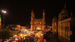
Hyderabad is the capital and largest city of the Indian state of Telangana. It occupies 650 km2 (250 sq mi) on the Deccan Plateau along the banks of the Musi River, in the northern part of Southern India. With an average altitude of 542 m (1,778 ft), much of Hyderabad is situated on hilly terrain around artificial lakes, including the Hussain Sagar lake, predating the city's founding, in the north of the city centre. According to the 2011 census of India, Hyderabad is the fourth-most populous city in India with a population of 6.9 million residents within the city limits, and has a population of 9.7 million residents in the metropolitan region, making it the sixth-most populous metropolitan area in India. With an output of US$ 95 billion, Hyderabad has the sixth-largest urban economy in India.

Hyderabad is a city and the capital of Hyderabad Division in the Sindh province of Pakistan. It is the second-largest city in Sindh, and the fifth largest in Pakistan.

Rawalpindi is the third-largest city in the Pakistani province of Punjab. It is a commercial and metropolitan city, being the fourth most populous in Pakistan. It is located near the Soan River in north-western Punjab, and is the third-largest Punjabi-speaking city in the world. Rawalpindi is situated adjacent to Pakistan's capital Islamabad, and the two are jointly known as "twin cities" because of the social and economic links between them.

Jabalpur, formerly Jubbulpore, is a city situated on the banks of Narmada River in the state of Madhya Pradesh, India. It is the 3rd-largest urban agglomeration of the state and the 38th-largest of the country. Jabalpur is the administrative headquarters of the Jabalpur district and the Jabalpur division. It is the judicial capital of Madhya Pradesh with Madhya Pradesh High Court being located in the city. It is generally accepted that the game of snooker originated in Jabalpur. Jabalpur is also the railway headquarters of the West Central Railway. Jabalpur Cantonment is one of the largest cantonments in India and houses the army headquarters of five states. The city is known for the marble rocks on the river Narmada at Bhedaghat. It is also known as 'Sanskardhani' meaning 'The Cultural Capital' highlighting the city's rich cultural and historical heritage. The city of Jabalpur was among the first 7 smart cities selected for the Smart Cities Mission.

Aurangabad, officially known as Chhatrapati Sambhaji Nagar, is a city in the Indian state of Maharashtra. It is the administrative headquarters of Aurangabad district, Maharashtra and is the largest city in the Marathwada region. Located on a hilly upland terrain in the Deccan Traps, Aurangabad is the fifth-most populous urban area in Maharashtra after Mumbai, Pune, Nagpur and Nashik with a population of 1,175,116. The city is known as a major production center of cotton textile and artistic silk fabrics. Several prominent educational institutions, including Dr. Babasaheb Ambedkar Marathwada University, are located in the city. The city is also a popular tourism hub, with tourist destinations like the Ajanta and Ellora caves lying on its outskirts, both of which have been designated as UNESCO World Heritage Sites since 1983. Other tourist attractions include the Aurangabad Caves, Devagiri Fort, Grishneshwar Temple, Jama Mosque, Bibi Ka Maqbara, Himayat Bagh, Panchakki and Salim Ali Lake. Historically, there were 52 Gates in Aurangabad, some of them extant, because of which Aurangabad is nicknamed as the "City of Gates". In 2019, the Aurangabad Industrial City (AURIC) became the first greenfield industrial smart city of India under the country's flagship Smart Cities Mission.
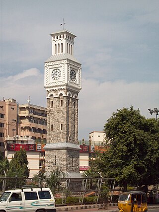
Secunderabad is a twin city of Hyderabad and one of the six zones of the Greater Hyderabad Municipal Corporation (GHMC) in the Indian state of Telangana. It is the headquarters of the South Central Railway zone. Named after the Mir Akbar Ali Khan Sikander Jah, Asaf Jah III, Nizam of the Asaf Jahi dynasty, Secunderabad was established in 1806 as a British cantonment. Although both the cities are together referred to as the twin cities, Hyderabad and Secunderabad have different histories and cultures, with Secunderabad having developed directly under British rule until 1948, and Hyderabad as the capital of the Nizams' princely state of Hyderabad. Since 1956, the city has housed the Rashtrapati Nilayam, the winter office of the president of India. It is also the headquarter of the 54th Infantry Division of the Indian Army.

Cantonments in Pakistan are permanent military bases of the Pakistan Army, which are administered by Cantonment Boards under the control of the Military Lands & Cantonments Department (ML&C), Ministry of Defence, Government of Pakistan. Cantonments are established under and governed by the Cantonments Act 1924.

Saddar Town, lies in the District Karachi South of the city that formed much of the historic colonial core of Karachi, Sindh province of Pakistan. According to 2023 Pakistani census Saddar Subdivision had a population 159,363.
Mithadar is one of the neighbourhoods of Saddar Town in Karachi, Sindh, Pakistan, and comprises the oldest part of Karachi that was once encircled by a wall. Mithadar and the adjacent community of Kharadar together form what is regarded as the original core of Karachi.

Greater Hyderabad Municipal Corporation (GHMC) is the civic body that oversees Hyderabad, the capital and largest city of the Indian state of Telangana. It is the local government for the city of Hyderabad. It is one of the largest municipal corporations in India with a population of 7.9 million and an area of 650 km2.
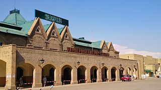
Rawalpindi Railway Station is located in Saddar area of Rawalpindi, Punjab, Pakistan. It is one of several major stops on the Karachi–Peshawar Railway Line. The nearest Saddar Metrobus Station, part of the Rawalpindi-Islamabad Metrobus is 20 minutes (1.5 km) walk away.
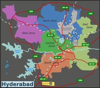
Secunderabad Cantonment Board is the civic administrative agency of Secunderabad cantonment area. Geographically, it lies in the twin cities of Hyderabad-Secunderabad. Secunderabad Cantonment Board is India’s second largest cantonment board, after Bathinda Cantonment. There are eight civilian wards in Secunderabad Cantonment Board, with a population of four lakh. Being primarily a military area, the Secunderabad cantonment comes under the administrative purview of the union defence ministry of the government of India. It is overseeing an area of 71.23 km2 (27.50 sq mi), where there are several military camps. Secunderabad Cantonment has a huge land bank, which has been protected since the British era.
Saddar, Rawalpindi, Pakistan, is the main commercial hub of Rawalpindi Cantonment. It is located between the Mall road and the main railway lines connecting Rawalpindi with down-country. It has some major business and commercial centres, main branches of major Pakistani banks, and residential areas of British colonial era. Saddar is a home to a dense cluster of residential and commercial buildings. Shops as well as shopping malls offer a diverse range of locally manufactured products and imported items. Chota Bazaar is a famous shopping area in northern Saddar.
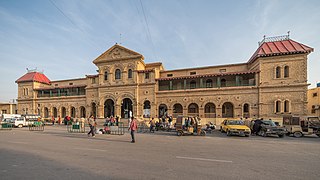
Karachi Cantonment Railway Station is one of the busiest and principal railway stations in Karachi, Sindh, Pakistan. It is situated near Dr. Daudpota Road, Saddar.

Pune Metropolitan Region (PMR) is the metropolitan region around the city of Pune. According to practical purposes, PMR comprises two Municipal Corporations of PMC, PCMC and three Cantonment Boards, spread over an area of 7,256.46 km2. The population of the region as per 2011 census was 7,541,946. It Contributes 80% GDP to Pune District and 9.2% GDP to Maharashtra.
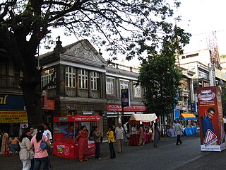
Pune Cantt, also known as Camp, is a military cantonment located in the city of Pune, India. It was established in 1817 for accommodating troops of the Indian Army. The cantonment houses many military establishments. It is also known for its shopping locations, MG Road and East Street. The headquarters of Indian Army's Southern Command is located in Pune Cantonment. The National War Memorial Southern Command which commemorates the sacrifice of soldiers of the Indian Armed Forces is also situated in the cantonment.
Saddar Bazaar is usually the main market or bazaar in most of the Cantonments of India and Pakistan.


