In geology a sag, or trough, is a depressed, persistent, low area; the opposite of an arch, or ridge, a raised, persistent, high area. The terms sag and arch were used historically to describe very large features, for example, characterizing North America as two arches with a sag between them.[1]
Also, a sag is a former river bed which has been partially filled with debris from glaciation or other natural processes but which is still visible in the surface terrain. Sags formed by the former river beds of large rivers often become the valleys of smaller streams after a change of course by the main river.
Examples of sags include the former continuations of the Grand, Moreau, and White rivers in South Dakota in the United States. Before the last ice age, these rivers continued eastward past their current confluences with the present course of Missouri River. The sags are prominently visible on the plateau of the Missouri Coteau, allowing small streams to drain into the Missouri from its eastern side.
Notes
↑ Charles Lapworth (August 18, 1892). "The British Association"(Opening address by head of the Geology Section). Nature. 46 (1190): 377. Bibcode:1892Natur..46..372.. doi:10.1038/046372a0. Retrieved September 17, 2011. ...the geographical surface of North America, considered as a whole, is in reality that of a double arch, with a sag or common trough in the middle.
Africa is a continent comprising 63 political territories, representing the largest of the great southward projections from the main mass of Earth's surface. Within its regular outline, it comprises an area of 30,368,609 km2 (11,725,385 sq mi), excluding adjacent islands. Its highest mountain is Mount Kilimanjaro, its largest lake is Lake Victoria.
A valley is an elongated low area often running between hills or mountains, which will typically contain a river or stream running from one end to the other. Most valleys are formed by erosion of the land surface by rivers or streams over a very long period of time. Some valleys are formed through erosion by glacial ice. These glaciers may remain present in valleys in high mountain or polar areas. At lower latitudes and altitudes, these glacially formed valleys may have been created or enlarged during ice ages but now are ice-free and occupied by streams or rivers. In desert areas, valleys may be entirely dry or carry a watercourse only rarely. In areas of limestone bedrock, dry valleys may also result from drainage taking place underground rather than at the surface. Rift valleys arise principally from earth movements, rather than erosion. Many different types of valley are described by geographers, using terms that may be global in use or else applied only locally.
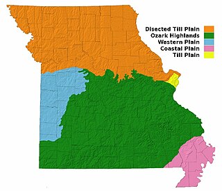
Missouri, a state near the geographical center of the United States, has three distinct physiographic divisions:
In geography and geology, fluvial processes are associated with rivers and streams and the deposits and landforms created by them. When the stream or rivers are associated with glaciers, ice sheets, or ice caps, the term glaciofluvial or fluvioglacial is used.
In oceanography, geomorphology, and geoscience, a shoal is a natural submerged ridge, bank, or bar that consists of, or is covered by, sand or other unconsolidated material and rises from the bed of a body of water to near the surface. It often refers to those submerged ridges, banks, or bars that rise near enough to the surface of a body of water as to constitute a danger to navigation. Shoals are also known as sandbanks, sandbars, or gravelbars. Two or more shoals that are either separated by shared troughs or interconnected by past or present sedimentary and hydrographic processes are referred to as a shoal complex.
The geology of the Grand Canyon area includes one of the most complete and studied sequences of rock on Earth. The nearly 40 major sedimentary rock layers exposed in the Grand Canyon and in the Grand Canyon National Park area range in age from about 200 million to nearly 2 billion years old. Most were deposited in warm, shallow seas and near ancient, long-gone sea shores in western North America. Both marine and terrestrial sediments are represented, including lithified sand dunes from an extinct desert. There are at least 14 known unconformities in the geologic record found in the Grand Canyon.
A body of water or waterbody is any significant accumulation of water, generally on a planet's surface. The term most often refers to oceans, seas, and lakes, but it includes smaller pools of water such as ponds, wetlands, or more rarely, puddles. A body of water does not have to be still or contained; rivers, streams, canals, and other geographical features where water moves from one place to another are also considered bodies of water.
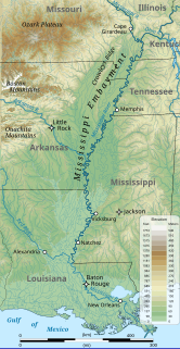
The Mississippi Embayment is a physiographic feature in the south-central United States, part of the Mississippi Alluvial Plain. It is essentially a northward continuation of the fluvial sediments of the Mississippi River Delta to its confluence with the Ohio River at Cairo, Illinois. The current sedimentary area was formed in the Cretaceous and early Cenozoic by the filling with sediment of a pre-existing basin. An explanation for the embayment's formation was put forward by Van Arsdale and Cox in 2007: movement of the earth's crust brought this region over a volcanic "hotspot" in the Earth's mantle causing an upthrust of magma which formed the Appalachian-Ouachita range. Subsequent erosion caused a deep trough that was flooded by the Gulf of Mexico and eventually filled with sediment from the Mississippi River.
The Gulf Coastal Plain extends around the Gulf of Mexico in the Southern United States and eastern Mexico.
The Dissected Till Plains are physiographic sections of the Central Lowlands province, which in turn is part of the Interior Plains physiographic division of the United States, located in southern and western Iowa, northeastern Kansas, the southwestern corner of Minnesota, northern Missouri, eastern Nebraska, and southeastern South Dakota.
In geology, cross-bedding, also known as cross-stratification, is layering within a stratum and at an angle to the main bedding plane. The sedimentary structures which result are roughly horizontal units composed of inclined layers. The original depositional layering is tilted, such tilting not being the result of post-depositional deformation. Cross-beds or "sets" are the groups of inclined layers, which are known as cross-strata.
U-shaped valleys, trough valleys or glacial troughs, are formed by the process of glaciation. They are characteristic of mountain glaciation in particular. They have a characteristic U shape in cross-section, with steep, straight sides and a flat or rounded bottom. Glaciated valleys are formed when a glacier travels across and down a slope, carving the valley by the action of scouring. When the ice recedes or thaws, the valley remains, often littered with small boulders that were transported within the ice, called glacial till or glacial erratic.
A misfit stream is a river that is deprived of its head waters and either too large or too small to have eroded the valley or cave passage in which it flows. This term is also used for a stream or river with meanders that obviously are not proportional in size to the meanders of the valley or meander scars cut into its valley walls. If the misfit stream is too large for either its valley or meanders, it is known as an overfit stream. If the misfit stream is too small for either its valley or meanders, it is known as an underfit stream.
A perennial stream or perennial river is a stream or river (channel) which has constant stream throughout the year through parts of its stream bed during years of normal rainfall. In the absence of irregular, prolonged, or extreme drought, a perennial stream is a watercourse, or segment, element, or emerging body of water which continually delivers groundwater. For example, an artificial disruption of stream, variability in flow or stream selection associated with the activity in hydropower installations, shall not affect the measurement. Perennial streams do not consist of stagnant water for the wetlands, reservoirs, and ponds that occur all the period. All other streams, or portions thereof, should be considered seasonal rivers or lakes. The stream can cycle from broken to perpetual through multiple iterations, to intermittent through its mechanism.
A stream is a body of water with surface water flowing within the bed and banks of a channel. The flow of a stream is controlled by three inputs – surface water, subsurface water and groundwater. The surface and subsurface water are highly variable between periods of rainfall. Groundwater, on the other hand, has a relatively constant input and is controlled more by long-term patterns of precipitation. The stream encompasses surface, subsurface and groundwater fluxes that respond to geological, geomorphological, hydrological and biotic controls.
A river is a natural flowing watercourse, usually freshwater, flowing towards an ocean, sea, lake or another river. In some cases, a river flows into the ground and becomes dry at the end of its course without reaching another body of water. Small rivers can be referred to using names such as stream, creek, brook, rivulet, and rill. There are no official definitions for the generic term river as applied to geographic features, although in some countries or communities a stream is defined by its size. Many names for small rivers are specific to geographic location; examples are "run" in some parts of the United States, "burn" in Scotland and northeast England, and "beck" in northern England. Sometimes a river is defined as being larger than a creek, but not always: the language is vague.
Freshwater environmental quality parameters are those chemical, physical or biological parameters that can be used to characterise a freshwater body. Because almost all water bodies are dynamic in their composition, the relevant quality parameters are typically expressed as a range of expected concentrations.
The Moenave Formation is a Mesozoic geologic formation, in the Glen Canyon Group. It is found in Utah and Arizona.
This glossary of geography terms is a list of definitions of terms and concepts used in geography and related fields, which describe and identify spatial dimension, geographic locations, topographical features, natural resources, and the collection, analysis, and visualization of geographic data. For related terms, see Glossary of geology and Glossary of environmental science.
The Muddy Creek Formation is a geologic formation in Arizona, California, Nevada, and Utah. It preserves fossils dating back to the Neogene period.
This page is based on this Wikipedia article Text is available under the CC BY-SA 4.0 license; additional terms may apply. Images, videos and audio are available under their respective licenses.