Sagres school

Last updated
Aerial view of Cape Sagres with the Fortress of Sagres Fortaleza de Sagres 2 - 11.04.2023.jpg
Aerial view of Cape Sagres with the Fortress of Sagres

The School of Sagres (Escola de Sagres in Portuguese), also called Court of Sagres is supposed to have been a group of figures associated with fifteenth century Portuguese navigation, gathered by prince Henry of Portugal in Sagres near Cape St. Vincent, the southwestern end of the Iberian Peninsula, in the Algarve.

Contents

Since the nearby port of Lagos was the actual point of departure for numerous expeditions of exploration and colonization along the African coast and Atlantic islands, the existence of a "school" at Sagres has been questioned by some historians. [1] [2] [3] [4] After the death of Prince Henry (1460), the center of Portuguese discoveries center shifted to Lisbon.

The first written mention of a "school" at Sagres in English dates from the seventeenth century by Samuel Purchas, although Damião de Gois had already pointed to a similar idea in the sixteenth century. Portuguese and English historians settled on the term and it gained popularity.

Scholarly debate

The monumental compass rose at Sagres, discovered in the 17th century. Sagres 3 Portugal 1991 (51869324757).jpg
The monumental compass rose at Sagres, discovered in the 17th century.

Romantic view

In 1894, C. R. Beazly published a biography of Prince Henry stating that he had installed his court in Sagres in 1418, shortly after the capture of Ceuta by the Portuguese. There he would have gathered the best of "science and navigation", built a shipyard and a palace with the first observatory in Portugal, even writing that Sagres represented the modern refounding of "the systematic study of applied science" in Christendom. [5] The diverse religious background of the members of the alleged "school" (Jews, Muslims, Christians), and even a remote connection to the Templars, given the fact that Prince Henry was the commander of the Order of Christ, have served to reinforce a romantic view of the matter.

Critical view

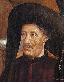
Prince Henry the Navigator Henry the Navigator1.jpg
Prince Henry the Navigator

Ever since then, others have nuanced that, rather than a nautical school in the modern sense of the word, Sagres was a meeting place for sailors and scientists to exchange information and techniques regarding maps, shipbuilding and organize expeditions. According to a more critical view, the Portuguese learned navigation in a practical way, on the decks of the ships, and lacking archaeological and documentary support for the supposed "school", consider it a myth of Portuguese history. [6] [1] [2] [3] [4]

Majorcan influence

The Majorcan school of cartography is known to have influenced Portuguese know-how, since Prince Henry commissioned the Jewish Majorcan Jehuda Cresques to produce portolans for him. According to the 16th century Portuguese navigator Pacheco Pereira:

"Muitos beneficios tem feytos o virtuoso Infante Dom Anrique a estes Reynos de Portugal, por que descubrió a ilha da Madeyra no anno de nosso senhor de mil CCCCXX, e ha mandau pouoar e mandou a Cicilia pellas canas de açuquar, ...; isso mesmo mandou á ilha de Malhorca por um mestre Jacome, mestre de cartas de marear, na qual ilha primeiramente se fezeram as ditas cartas, e com muitas dadiuas e mercés ho ouue nestes Reynos, ho qual as ensinou a fazer áquelles de que os que em nosso tempo viuem, aprendéram..." [7]

The 16th century Portuguese chronicler João de Barros on his part states:

"..mándou vir da ilha de Mallorca um mestre Jacome, homem mui douto na arte de navegar, que fasia e instrumentos náuticos e que Ihe custou muito pelo trazer a este reino para ensinar sua sciencia aos officiaes portuguezes d'aquella mester" [8]

Though some wonder if the mestre Jacome mentioned in Portuguese sources corresponded to the same mestre Jacome from Maiorca, no other person from that era is known to have bore the same name.

First results

João Gonçalves Zarco located Porto Santo in 1419 and Madeira in 1420, while Diogo de Silves found the island of Santa Maria in 1427. In 1434 Gil Eanes rounded Cape Bojador. It had taken twelve years to sail beyond two hundred miles separating the Cape Não from Cape Bojador. Beyond that a point begun the "Dark Sea" feared by Arab geographers, due to the difficulty of sailing back north due to contrary winds. A solution to this problem was eventually achieved in the second quarter of the fifteenth century, by means of high sea sailing, returning by a route far away from the coast, dubbed by the Portuguese as Volta do Mar . This breakthrough was achieved through the use of a suitable vessel, the Caravel, used for fishing and characterized for its robustness and shallowness, with a tonnage from 50 to 160 tonnes and 1 to 3 masts with triangular Latin sails.

See also

Related Research Articles

<span class="mw-page-title-main">Prince Henry the Navigator</span> Portuguese navigator and Prince (1394–1460)

Dom Henrique of Portugal, Duke of Viseu, better known as Prince Henry the Navigator, was a central figure in the early days of the Portuguese Empire and in the 15th-century European maritime discoveries and maritime expansion. Through his administrative direction, he is regarded as the main initiator of what would be known as the Age of Discovery. Henry was the fourth child of King John I of Portugal, who founded the House of Aviz.

<span class="mw-page-title-main">Senegal River</span> River in West Africa

The Senegal River is a 1086-kilometre-long (675 mi) river in West Africa; much of its length marks part of the border between Senegal and Mauritania. It has a drainage basin of 270000 km2, a mean flow of 680 m3/s (24,000 cu ft/s), and an annual discharge of 21.5 km3 (5.2 cu mi). Important tributaries are the Falémé River, Karakoro River, and the Gorgol River. The river divides into two branches once it passes Kaédi The left branch, called the Doué, runs parallel to the main river to the north. After 200 km (120 mi) the two branches rejoin a few kilometers downstream of Podor.

<span class="mw-page-title-main">Jehuda Cresques</span> Cartographer from Palma, Majorca

Jehudà Cresques, also known as Jafudà Cresques, Jaume Riba, and Cresques lo Juheu, was a converso cartographer from Majorca in the early 15th century.

<span class="mw-page-title-main">Sagres Point</span> Promontory of southern Portugal

Sagres Point is a windswept shelf-like promontory located in the southwest Algarve region of southern Portugal. Only 4 km to the west and 3 km to the north lies Cape St. Vincent, which is usually taken as the southwesternmost tip of Europe. The vicinity of Sagres Point and Cape St. Vincent has been used for religious purposes since Neolithic times, to which standing menhirs near Vila do Bispo, a few miles from both points, attest.

Cape Bojador is a headland on the west coast of Western Sahara, at 26° 07' 37"N, 14° 29' 57"W, as well as the name of the large nearby town with a population of 42,651. The name of the surrounding province also derives its name from the cape.

<span class="mw-page-title-main">Gil Eanes</span> Portuguese navigator and explorer

Gil Eanes was a 15th-century Portuguese navigator and explorer.

<span class="mw-page-title-main">Military Order of Christ</span> Former order of the Kingdom of Portugal

The Military Order of Christ is the former order of Knights Templar as it was reconstituted in Portugal. Before 1910, it was known as the Royal Military Order of Our Lord Jesus Christ, and the Order of the Knights of Our Lord Jesus Christ. It was founded in 1319, with the protection of King Denis of Portugal, after the Templars were abolished on 22 March 1312 by the papal bull, Vox in excelso, issued by Pope Clement V. King Denis refused to pursue and persecute the former knights as had occurred in most of the other sovereign states under the political influence of the Catholic Church.

Diogo de Silves is the presumed name of an obscure Portuguese explorer of the Atlantic who allegedly discovered the Azores islands in 1427.

Jácome de Bruges, 1st Captain-Donee of Terceira was the brother of Louis de Gruuthuse, 1st Earl of Winchester of the wealthy Gruuthuse noble family from Bruges, their grandfather Jean III d'Aa of Gruuthuse participated in the great tournament of Bruges on 11 March, 1393. Jácome became a servant of Prince Henry the Navigator of Portugal, who initiated the so-called Portuguese Age of Discovery in the 15th century.

<span class="mw-page-title-main">Abraham Cresques</span> 14th-century Jewish cartographer from Majorca

Abraham Cresques, whose real name was Cresques (son of) Abraham, was a 14th-century Jewish cartographer from Palma, Majorca, then part of the Crown of Aragon. In collaboration with his son, Jehuda Cresques, Cresques is credited with the authorship of the celebrated Catalan Atlas of 1375.

<span class="mw-page-title-main">Portolan chart</span> Nautical charts, first made in the 13th century

Portolan charts are nautical charts, first made in the 13th century in the Mediterranean basin and later expanded to include other regions. The word portolan comes from the Italian portolano, meaning "related to ports or harbors", and which since at least the 17th century designates "a collection of sailing directions".

<span class="mw-page-title-main">Afonso Gonçalves Baldaia</span> Portuguese explorer

Afonso Gonçalves Baldaia was a 15th-century Portuguese nautical explorer. He explored much of the coast of Western Sahara in 1435–1436 on behalf of the Portuguese prince Henry the Navigator. He would later become one of the first colonists of Terceira Island in the Azores.

<span class="mw-page-title-main">Majorcan cartographic school</span> Medieval naval group

"Majorcan cartographic school" is the term coined by historians to refer to the collection of predominantly Jewish cartographers, cosmographers and navigational instrument-makers and some Christian associates that flourished in Majorca in the 13th, 14th and 15th centuries until the expulsion of the Jews. The label is usually inclusive of those who worked in Catalonia. The Majorcan school is frequently contrasted with the contemporary Italian cartography school.

Lançarote de Freitas, better known as Lançarote de Lagos or Lançarote da Ilha, was a 15th-century Portuguese explorer and slave trader from Lagos, Portugal. He was the leader of two large Portuguese slaving raids on the West African coast in 1444–46.

Jaume Ferrer was a Majorcan sailor and explorer. He sailed from Majorca on 10 August 1346 to find the legendary "River of Gold," but the outcome of his quest and his fate are unknown. He is memorialized in his native city of Palma, Majorca.

Gabriel de Vallseca, also referred to as Gabriel de Valseca and Gabriel de Valsequa was a cartographer of Jewish descent connected to the Majorcan cartographic school. His most notable map is the portolan of 1439, containing the first depiction of the recently-discovered Azores islands.

<span class="mw-page-title-main">Castle of Lagos</span> Medieval castle in Lagos, Portugal

The Castle of Lagos is a medieval castle located in the municipality of Lagos, Portugal. Its walls surrounded the entire city of Lagos, providing the town its main means of defence.

<i>La Cartografía Mallorquina</i>

La Cartografía Mallorquina is a book of essays on the Majorcan portolans written by Professor Julio Rey Pastor with the collaboration of Ernesto García Camarero. It is a scholarly essay, a key element in the study of portolans, especially those made by Majorcans as half of the book is devoted to the study of more than 400 Majorcan portolans existing worldwide.

<i>Esmeraldo de Situ Orbis</i> Manuscript by Duarte Pacheco Pereira

Esmeraldo de Situ Orbis is an early modern work on cosmography and Atlantic exploration written by the Portuguese geographer and navigator Duarte Pacheco Pereira.

<span class="mw-page-title-main">Jaime Cortesão</span> Portuguese politician

Jaime Zuzarte Cortesão was a Portuguese medical doctor, politician, historian and writer.

References

  1. 1 2 Randles (1993). The Alleged nautical school founded in the fifteenth century by Prince Henry at Sagres of Portugal, called the 'Navigator'. Vol. 45. Imago Mundi. pp. 20–28.
  2. 1 2 Luís de Albuquerque (1990). Dúvidas e certezas na história dos descobrimentos portugueses. Vega. ISBN   978-972-699-273-8.
  3. 1 2 Rocha, Daniel (8 February 2009). Brazil: nega historian existência da Escola Sagres. Público. Retrieved 16 October 2013.
  4. 1 2 Marques, Alfredo Pinheiro (2005). Os Descobrimentos e o 'Miller Atlas' (in Portuguese). University of Coimbra. p. 160.
  5. Beazley, C. R. (1894). Prince Henry the Navigator: The Hero of Portugal and of Modern Discovery, 1394-1460 AD With an Account of Geographical Progress THROUGHOUT the Middle Ages as the Preparation for His Work. Putnam. pp. 160–162.
  6. Marques, Alfredo Pinheiro (2005). Os Descobrimentos e o 'Miller Atlas' (in Portuguese). University of Coimbra. pp. 52–53.
  7. Estudos de História, Volume III. UC Biblioteca Geral 1. pp. 10–. GGKEY:7186FCQBHS5.
  8. Bibliografia Henriquina, Vol. I. UC Biblioteca Geral 1. pp. 2–. GGKEY:PGJ4UJDUYAZ.