Sagvåg

Last updated
Sagvåg
Village
Norway Hordaland location map.svg
Red pog.svg
Sagvåg
Location in Hordaland county
Norway location map.svg
Red pog.svg
Sagvåg
Sagvåg (Norway)
Coordinates: 59°46′53″N05°23′23″E / 59.78139°N 5.38972°E / 59.78139; 5.38972 Coordinates: 59°46′53″N05°23′23″E / 59.78139°N 5.38972°E / 59.78139; 5.38972
Country Norway
Region Western Norway
County Hordaland
District Sunnhordland
Municipality Stord
Area [1]
  Total 2.59 km2 (1.00 sq mi)
Elevation [2] 38 m (125 ft)
Population (2013) [1]
  Total 3,416
  Density 1,319/km2 (3,420/sq mi)
Time zone CET (UTC+01:00)
  Summer (DST) CEST (UTC+02:00)
Post Code5410 Sagvåg

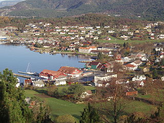
Sagvåg is a village in Stord municipality in Hordaland county, Norway. The village is located on the southwest coast of the island of Stord, about 5 kilometres (3.1 mi) west of the town of Leirvik. The Stord Airport, Sørstokken lies about 2 kilometres (1.2 mi) northwest of Sagvåg. Nysæter Church was built here in 1991 to serve the population of the village. The small mining village of Litlabø lies just northeast of Sagvåg. [3]

Stord Municipality in Hordaland, Norway

Stord is a municipality in Hordaland county, Norway. It is located in the traditional district of Sunnhordland. Stord is sometimes called "Norway in miniature" since it has such a variety of landscapes: coastline, fjords, forests, agricultural land, and mountain areas. The administrative centre of the municipality is the town of Leirvik, which is also the largest town in the municipality and the whole region of Sunnhordland. Leirvik was declared a town in 1997. Other population centres in the municipality include the large village of Sagvåg and the smaller villages of Litlabø and Grov.

Hordaland County (fylke) of Norway

Hordaland is a county in Norway, bordering Sogn og Fjordane, Buskerud, Telemark, and Rogaland counties. Hordaland is the third largest county after Akershus and Oslo by population. The county government is the Hordaland County Municipality which is located in Bergen. Before 1972, the city of Bergen was its own separate county apart from Hordaland.

Norway constitutional monarchy in Northern Europe

Norway, officially the Kingdom of Norway, is a Nordic country in Northwestern Europe whose territory comprises the western and northernmost portion of the Scandinavian Peninsula; the remote island of Jan Mayen and the archipelago of Svalbard are also part of the Kingdom of Norway. The Antarctic Peter I Island and the sub-Antarctic Bouvet Island are dependent territories and thus not considered part of the kingdom. Norway also lays claim to a section of Antarctica known as Queen Maud Land.

View of a boat being built at Ottesens Skipsbyggeri in Sagvag. (date unknown) Ottesens skipsproduksjon.jpg
View of a boat being built at Ottesens Skipsbyggeri in Sagvåg. (date unknown)

The 2.59-square-kilometre (640-acre) village has a population (2013) of 3,416. This gives the village a population density of 1,319 inhabitants per square kilometre (3,420/sq mi). [1] This makes it Sunnhordland's second largest community, after the nearby town of Leirvik.

Population density A measurement of population numbers per unit area or volume

Population density is a measurement of population per unit area or unit volume; it is a quantity of type number density. It is frequently applied to living organisms, and most of the time to humans. It is a key geographical term. In simple terms population density refers to the number of people living in an area per kilometer square.

Sunnhordland District in Hordaland, Norway

Sunnhordland is a traditional district in the Vestlandet region of Norway. The district consists of the southern coastal regions of Hordaland county. In includes the areas that surround the mouth of the Hardangerfjorden and the surrounding islands. The municipalities of Sveio, Etne, Stord, Bømlo, Fitjar, Kvinnherad, and Tysnes make up the district of Sunnhordaland. The regional centre of this district is the town of Leirvik in Stord.

Leirvik Town in Western Norway, Norway

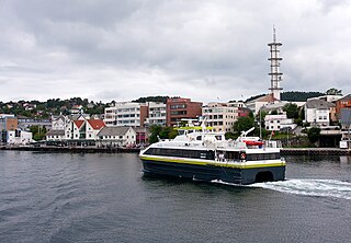
Leirvik is a town and the administrative centre of Stord municipality in Hordaland county, Norway. The town lies along the southern coast of the large island of Stord, along the Hardangerfjorden. The town gained "town status" in 1997. The town includes the Eldøyane peninsula where the large Kværner Stord industrial area is located.

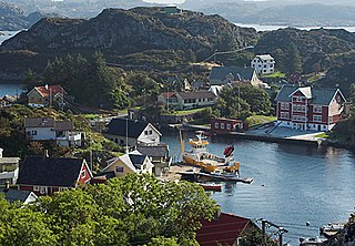
Wärtsilä Norway AS has a factory in Sagvåg, producing automation systems for the marine industry. The harbour of Sagvåg is noted to be excellent for visiting leisure boats. There was considerable shipbuilding activities in Sagvåg up until the 1960s, building wooden fishing and whaling vessels. Prior to the Triangle Link bridges and tunnel in 2001, Sagvåg was a ferry port with regular ferry routes connecting Stord and Bømlo to the west.

Wärtsilä Finnish corporation

Wärtsilä Oyj Abp is a Finnish corporation which manufactures and services power sources and other equipment in the marine and energy markets. The core products of Wärtsilä include technologies for the energy sector, including gas, multi-fuel, liquid fuel and biofuel power plants and energy storage systems; and technologies for the marine sector, including cruise ships, ferries, fishing vessels, merchant ships, navy ships, special vessels, tugs, yachts and offshore vessels. Ship design capabilities include ferries, tugs, and vessels for the fishing, merchant, offshore and special segments. Services offerings include online services, underwater services, turbocharger services, and also solutions for the marine, energy, and oil and gas markets. At the end of June 2018, the company employed more than 19,000 workers.

Triangle Link

The Triangle Link is a fixed link with three branches that connects the islands of Stord and Bømlo to each other and to the mainland at Sveio, Norway. It consists of the underwater Bømlafjord Tunnel from Sveio to the island of Føyno, the Stord Bridge from there to Stord, and a road including the Bømla Bridge and the Spissøy Bridge to Bømlo. The section from Sveio to Stord is part of European Route E39, while the branch to Bømlo is part of County Road 542.

Bømlo (island) island in the municipality Bømlo in Norway

Bømlo is an island in Hordaland county, Norway. At 171 square kilometres (66 sq mi), it is the largest island in the island municipality Bømlo lying just off the western coast of Norway. The island sits at the northern entrance to the vast Hardangerfjorden, west of the Stokksundet strait, south of the Selbjørnsfjorden, and east of the North Sea. In the 1800s, the Kulleseid Canal was built across a small isthmus in the central part of the island, giving a shortcut from the eastern side of the island to the western side of the island.

Related Research Articles

Fitjar Municipality in Hordaland, Norway

Fitjar is a municipality in Hordaland county, Norway. The municipality is located in the traditional district of Sunnhordland. Fitjar municipality includes the northern part of the island of Stord and the hundreds of surrounding islands, mostly to the northwest of the main island. The administrative centre of the municipality is the village of Fitjar.

Huglo

Huglo is an island in Stord municipality in Hordaland county, Norway. The 13.5-square-kilometre (5.2 sq mi) island lies in the Hardangerfjorden, just east of the large island of Stord and just south of Tysnesøy. The small island of Skorpo lies immediately northeast of this island. The highest point on the rugged island is the 218-metre (715 ft) tall Høgafjellet.

Norheimsund Village in Western Norway, Norway

Norheimsund is the administrative centre of the municipality of Kvam in Hordaland county, Norway. The village is located on the northern side of the Hardangerfjord, about 80 kilometres (50 mi) from the city of Bergen. The village of Øystese lies about 4 kilometres (2.5 mi) to the northeast and the village of Vikøy lies about 3 kilometres (1.9 mi) southeast of Norheimsund. The village of Steine is a suburb, immediately to the west of Norheimsund. The 2.5-square-kilometre (620-acre) village has a population (2012) of 2,224; giving the village a population density of 890 inhabitants per square kilometre (2,300/sq mi), the largest settlement in the whole municipality.

Langevåg, Hordaland Village in Western Norway, Norway

Langevåg is a village in Bømlo municipality in Hordaland county, Norway. It is located on the southern tip of the island of Bømlo, along the Bømlafjorden. It lies in the far southern part of the municipality, about 12 kilometres (7.5 mi) south of the village of Lykling. The 1.15-square-kilometre (280-acre) village has a population (2013) of 796, giving the village a population density of 692 inhabitants per square kilometre (1,790/sq mi). This makes it the fourth largest village in the municipality.

Grov, Hordaland Village in Western Norway, Norway

Grov is a village in Stord municipality in Hordaland county, Norway. The village is located on the island of Stord, about a 7-minute drive north of the town of Leirvik. Grov lies along the European route E39 highway and the Langenuen strait, overlooking the island of Huglo across the strait. Grov is known for its fantastic natural surroundings and peaceful life by the sea.

Osøyro Village in Western Norway, Norway

Osøyro is the administrative centre of Os municipality in Hordaland county, Norway. The village lies on the southwestern part of the Bergen Peninsula, along the western shore of the Fusafjorden, about 25 kilometres (16 mi) south of the city centre of Bergen. The European route E39 highway runs through the village on its way to Bergen. There is a car ferry from the east side of Osøyro to the village of Fusa, across the Fusafjorden. Os Church is located in the village.

Selbjørn island in Norway

Selbjørn is an island in Austevoll municipality in Hordaland county, Norway. The 25-square-kilometre (9.7 sq mi) island is the second largest in the municipality. Most of the population lives along the northern and eastern coastlines of the island. The commercial centre of Selbjørn is the village of Bekkjarvik, where Bekkjarvik Church is located.

Huftarøy island in Norway

Huftarøy is the largest island in the municipality of Austevoll in Hordaland county, Norway. The 50.4-square-kilometre (19.5 sq mi) island lies in the Austevoll archipelago, just west of the Bjørnafjorden, south of the Korsfjorden, east of the Mokstrafjorden, and north of the Selbjørnsfjorden. The largest settlement on the island is the municipal centre of Storebø on the northern part of the island.

Hausvik Village in Western Norway, Norway

Haus or Hausvik is a village in Osterøy municipality in Hordaland county, Norway. The village is located on the southwestern coast of the island of Osterøy along the Sørfjorden. The village lies across the Sørfjorden from the villages of Ytre Arna and Garnes. The village of Valestrandfossen lies about 7 kilometres (4.3 mi) north along the fjord. The 0.38-square-kilometre (94-acre) village has a population (2013) of 619, giving the village a population density of 1,629 inhabitants per square kilometre (4,220/sq mi).

Stord (island) island in Hordaland county, Norway

Stord is an island in Hordaland county, Norway. Located in the traditional district of Sunnhordland, the island is part of the municipalities of Stord and Fitjar. The largest settlements on the island are the town of Leirvik and the villages of Sagvåg and Fitjar.

Nautøy

Nautøy or Nautøya is an unpopulated island in Stord municipality in Hordaland county, Norway. It sits at the southern end of the Stokksund sound about 3.5 kilometres (2.2 mi) south of the village of Sagvåg. The island is connected to the nearby island of Spissøy by the Bømla Bridge and to the nearby island of Føyno via a small bridge. Country Road 542, part of the Triangle Link, runs across the island.

Sørstokken is a peninsula on the island of Stord in the municipality of Stord in Hordaland county, Norway. The peninsula is 3.4 kilometres (2.1 mi) long and about 1 kilometre (0.62 mi) wide. It is connected to the main part of the island by a 500-metre (1,600 ft) wide isthmus. Other than a small residential area on the isthmus, Stord Airport, Sørstokken is the only major thing located on the peninsula. The peninsula is located about 13 kilometres (8.1 mi) northwest of the town of Leirvik.

Litlabø Village in Western Norway, Norway

Litlabø is a village and former mining community in the municipality of Stord in Hordaland county, Norway. It is located at the northern side of the lake of Storavatnet, just northeast of the village of Sagvåg. The village had about 450 inhabitants as of 2001. Litlabø was the location for the pyrite mines of Stordø Kisgruber, which operated from 1907 to 1968.

Fitjar (village) Village in Western Norway, Norway

Fitjar  is the administrative centre of Fitjar municipality in Hordaland county, Norway. The village is located on the northwestern shore of the island of Stord. It sits at the southern end of the Fitjarvika bay, a small arm off the main Selbjørnsfjorden. A large group of small islands lie just off the coast to the west. The 1.33-square-kilometre (330-acre) village has a population (2013) of 1,472 which gives it a population density of 1,107 inhabitants per square kilometre (2,870/sq mi). Fitjar Church is located in this central part of this village. The historic Battle of Fitjar took place in this area in the year 961.

Stord Church Church in Hordaland, Norway

Stord Church is a parish church in Stord municipality in Hordaland county, Norway. It is located in the town of Leirvik on the southern side of the island of Stord. The church is part of the Stord parish in the Sunnhordland deanery in the Diocese of Bjørgvin. The white, stone church was built in 1857 and it seats about 530 people.

Nysæter Church Church in Hordaland, Norway

Nysæter Church is a parish church in Stord municipality in Hordaland county, Norway. It is located in the village of Sagvåg on the southwestern coast of the island of Stord. The church is part of the Nysæter parish in the Sunnhordland deanery in the Diocese of Bjørgvin. The brick church was built in 1991 by the architect Colin Ansbach. The church, which seats about 350 people, was consecrated in January 1992. The sanctuary has a fan-shaped design.

Skånevik (village) Village in Western Norway, Norway

Skånevik is a village in Etne municipality in Hordaland county, Norway. The village is located along the Skånevikfjorden, near the entrance to the Åkrafjorden. The village lies across the fjord from the village of Utåker in neighboring Kvinnherad municipality. The municipal centre of Etnesjøen lies about 8 kilometres (5.0 mi) straight south across a mountain, although one must drive about 22 kilometres (14 mi) around the mountain to get there.

References

  1. 1 2 3 Statistisk sentralbyrå (1 January 2013). "Urban settlements. Population and area, by municipality".
  2. "Sagvåg, Stord (Hordaland)" (in Norwegian). yr.no . Retrieved 2015-02-04.
  3. Store norske leksikon. "Sagvåg" (in Norwegian). Retrieved 2015-02-04.