
Fitovinany is a region located in southeast Madagascar. Its capital is Manakara. It is inhabited by the Antemoro people.

Amoron'i Mania is a region in central Madagascar bordering Vakinankaratra Region in north, Atsinanana in northeast, Vatovavy-Fitovinany in southeast, Haute Matsiatra in south, Atsimo-Andrefana in southwest and Menabe in west.

Atsinanana is a coastal region in eastern Madagascar. It borders Analanjirofo region in the north, Alaotra-Mangoro in the west, Vakinankaratra and Amoron'i Mania in the southwest, and Vatovavy and Fitovinany in south. The region contains over 285km of coastline, which includes many beaches and cultural heritage sites.
Ambohitompoina is a town and commune in Madagascar. It belongs to the district of Antanifotsy, which is a part of Vakinankaratra Region. The population of the commune was 27,899 in 2018.
Mahazoarivo is a town and commune in Madagascar. It belongs to the district of Fandriana, which is a part of Amoron'i Mania Region. The population of the commune was 11,869 in 2019, distributed over 21 Fokontany (villages).
Marolambo is a village and commune (kaominina) located in the Atsinanana region of eastern Madagascar. It is along the Nosivolo River near the junction with the Sandranamby River, and is also the capital of the Marolambo District.
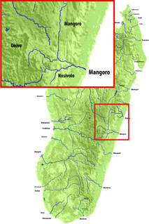
The Nosivolo River is a river in eastern Madagascar and a primary tributary of the Mangoro River. It begins east of Fandriana. The village of Marolambo, capital of the Marolambo District in the Atsinanana region, is located along the river at the junction with the Sandranamby River.
Marolambo is a district of Atsinanana in Madagascar.
The Marolambo National Park covers a forested region of Eastern Madagascar, between Marolambo, Antanifotsy, Fandriana, Nosy Varika (Vatovavy), Ifanadiana (Vatovavy) and Ambositra.
Betampona is a rural commune located in the Atsinanana region of eastern Madagascar. It belongs to the Marolambo District.
Lohavanana is a commune located in the Atsinanana region of eastern Madagascar. It belongs to the Marolambo District.
Anosiarivo is a rural municipality located in the Atsinanana region of eastern Madagascar. It belongs to the Marolambo District.
Ambatofisaka II is a rural municipality located in the Atsinanana region of eastern Madagascar. It belongs to the Marolambo District.
Ambalapaiso II is a rural municipality located in the Atsinanana region of eastern Madagascar. It belongs to the Marolambo District.
Ambodinonoka is a rural municipality located in the Atsinanana region of eastern Madagascar. It is in the Marolambo District.
Ambohimilanja is a rural municipality located in the Atsinanana region of eastern Madagascar. It is located in the Marolambo District.
Andonabe Sud is a rural municipality located in the Marolambo District, Atsinanana region of eastern Madagascar
Androrangavola is a rural municipality located in the Marolambo District, Atsinanana region of eastern Madagascar
Amboasary is a rural municipality located in the Marolambo District, Atsinanana region of eastern Madagascar. It borders West of the Marolambo National Park
Ambinanindrano is a rural municipality located in the Mahanoro District, Atsinanana region of eastern Madagascar
