
Kotturpuram, also known as Kottur, is a neighbourhood in Chennai (Madras), Tamil Nadu, India and is situated in the Southern banks of the Adyar River. It is surrounded by Nandanam in the North and North-West, Adyar in the South-East, IIT Chennai and Guindy in the South and Little Mount in the South-West. The neighbourhood is served by Kotturpuram MRTS railway station. Centuries old Hindu temples, such as Perumal Koil and Ponniamman Koil are situated in Kottur.

Porur is a neighbourhood of Chennai, India. It is situated in the Maduravoyal taluk of Chennai district in the southern part of the city. Since 2011, it has been a part of the Chennai Corporation and included in zone number 11.

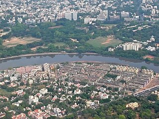
Saidapet, also known as Saidai, is a neighbourhood in Chennai, India, situated in the northern banks of the Adyar River and serves as an entry point to Central Chennai. It is surrounded by West Mambalam in the North, C.I.T Nagar in the North-East, Nandanam in the East, Guindy in the South, Jafferkhanpet and Ashok Nagar in the North-West. The Saidapet Court, the only other court of judicature in Chennai city apart from the Madras High Court, and the Saidapet bus depot are located here. Prior to its incorporation in Madras city, Saidapet functioned as the administrative headquarters of Chingleput district. The neighbourhood is served by Saidapet railway station of the Chennai Suburban Railway Network.
Saligramam (சாலிகிராமம்) is a residential locality situated in the western part of Chennai, Tamil Nadu, India. Saligramam is surrounded by Vadapalani in the east, Virugambakkam in the west, KK Nagar in the south and Koyambedu in the north. Saligramam was part of Saidapet Taluk in Chengalpattu district before it was merged with Chennai City and district in 1977.
Valasaravakkam is a neighbourhood in the Chennai district of the Indian state of Tamil Nadu and a residential suburb of the city of Chennai. It is located in the Poonamallee Taluk at a distance of approximately 15 kilometres from the Kilometer Zero stone. Valasaravakkam lies on the Arcot Road, one of Chennai's arterial roads. It is under the Maduravoyal election constituency. In October, 2011 Valasaravakkam Municipality ceased to exist and the area became part of Chennai Corporation as Ward Nos 149 and 152, Southern Region, Corporation of Chennai. As of 2011, the town had a population of 47,378. Famous Sivan temple is in Kesavardhini.
West Mambalam is a residential and commercial area in Chennai, India. It is known for its shops, bazaars and Hindu temples. It is bounded by Kodambakkam to the north and Saidapet to the south. T. Nagar and Nandanam stretch all along its eastern frontiers while Ashok Nagar lies to its west. The Ayodhya Mandapam is an important landmark.
Nandanam is a neighborhood in Chennai, India. It is a busy location and is home to many commercial institutions. This locality also offers a calm residential location. Nandanam Arts College was established in 1901. Nandanam Junction, on the arterial road Anna Salai, is one of the busiest junctions in Chennai.

Ma. Subramanian is an Indian Tamil lawyer, businessman and politician. He serves as a Minister for Health and Family Welfare of Tamil Nadu since 7 May 2021. He served as Mayor of Chennai from 2006 to 2011, the capital of the Indian state of Tamil Nadu. He is a member of the Dravida Munnetra Kazhagam (DMK) party. He is a lawyer by profession.

Saidapet is a constituency of the legislative assembly of the Indian state of Tamil Nadu. It covers the city of Saidapet in Chennai district and forms a part of Chennai South constituency for elections to the Parliament of India. Its State Assembly Constituency number is 23. It is one of the 234 State Legislative Assembly Constituencies in Tamil Nadu, in India.
Mambalam taluk is a taluk of the city district of Chennai in the Indian state of Tamil Nadu. It was formed in December 2013 from parts of the former Egmore-Nungambakkam taluk and the Mambalam-Guindy taluk. It comprises the neighbourhoods of K. K. Nagar, Kodambakkam, Mambalam, Saligramam, Saidapet and Virugambakkam.

Chingleput district was a district in the Madras Presidency of British India. It covered the area of the present-day districts of Kanchipuram, Chengalpattu and Tiruvallur and parts of Chennai city. It was sub-divided into six taluks with a total area of 7,970 square kilometres (3,079 sq mi). The first capital was the town of Karunguzhi, with an interruption between 1825 and 1835, administrative headquarters were transferred to Kanchipuram. In 1859 the capital Saidapet, now a neighbourhood in the city of Chennai, was made the administrative headquarters of the district.
This is a timeline of major events in the history of Chennai.
Saidapet Kamakshi Amman Temple is a Hindu temple in Chennai, Tamil Nadu, India. Located in Chetty Street in the neighbourhood of Saidapet, the temple is administered by the Vishwakarma community. The presiding deity is the goddess Kamakshi. The temple is located near the Saidapet railway station and is believed to be more than 300 years old. The temple is one of the five holy shrines of the Viswakarma community in Chennai district.
Angalamman Temple is a Hindu temple located in the neighbourhood of Choolai in Chennai, India. The temple has two separate shrines for Kasi Viswanatha, Angalamman and Virat Viswakarma. The temple is administered by the Ministry of Hindu Religious and Charitable Endowments of the Government of Tamil Nadu. The temple is one of the five holy shrines of the Viswakarma community in Chennai district.

Saidapet railway station is one of the railway stations of the Chennai Beach–Chengelpet section of the Chennai Suburban Railway Network. It serves the neighbourhoods of Saidapet and Little Mount. It is situated about 12 km (7.5 mi) from Chennai Beach, and has an elevation of 10 m (33 ft) above sea level.
Sembium is a former panchayat which was annexed to Chennai in 1946. It was a sub-taluk of Saidapettai taluk of Old Chinglepet District.
The Long Tank was a natural lake which was situated on the western frontier of the city Madras, India. Comprising two sections - the Mylapore Tank to the south and a feeder lake Nungambakkam Tank to the north, it extended for about five miles from Sterling Road in the north to the suburb of Saidapet in the south. About a mile in width, it formed the boundary of Madras city as well as the district till 1921.
Kadambathur, also spelt Kadambattur, is a town located in Tiruvallur district in the Indian state of Tamil Nadu. It is a census town in Tiruvallur taluk. According to the 2011 census, the town has a population of 11,235.

Saidapet metro station is a Metro railway station on the Blue Line of the Chennai Metro. The station is among the under ground stations along corridor I of the Chennai Metro, Wimco Nagar–Chennai International Airport stretch. The station serves the neighbourhood of Saidapet.

The Institute of Advanced Study in Education, popularly known as Teachers' College is the oldest teacher training institute in India located in Saidapet, Chennai.
