Puget Sound is a sound along the northwestern coast of the U.S. state of Washington, an inlet of the Pacific Ocean, and part of the Salish Sea. It is a complex estuarine system of interconnected marine waterways and basins, with one major and two minor connections to the open Pacific Ocean via the Strait of Juan de Fuca—Admiralty Inlet being the major connection and Deception Pass and Swinomish Channel being the minor.

The Strait of Juan de Fuca is a large body of water about 154 kilometres (96 mi) long that is the Salish Sea's outlet to the Pacific Ocean. The international boundary between Canada and the United States runs down the center of the Strait.
The Strait of Georgia or the Georgia Strait is an arm of the Pacific Ocean between Vancouver Island and the extreme southwestern mainland coast of British Columbia, Canada and the extreme northwestern mainland coast of Washington, United States. It is approximately 240 kilometres (150 mi) long and varies in width from 20 to 58 kilometres. Along with the Strait of Juan de Fuca and Puget Sound, it is a constituent part of the Salish Sea. Archipelagos and narrow channels mark each end of the Strait of Georgia, the Gulf Islands and San Juan Islands in the south, and the Discovery Islands in the north. The main channels to the south are Boundary Pass, Haro Strait and Rosario Strait, which connect the Strait of Georgia to the Strait of Juan de Fuca. In the north, Discovery Passage is the main channel connecting the Strait of Georgia to Johnstone Strait. The strait is a major navigation channel on the west coast of North America, owing to the presence of the port of Vancouver, and also due to its role as the southern entrance to the infracoastal route known as the Inside Passage.

The Nooksack River is a river in the northwest part of the U.S. state of Washington. It drains an area of the Cascade Range around Mount Baker, near the Canada–US border. The lower river flows through a fertile agricultural area before emptying into Bellingham Bay and, via the Strait of Juan de Fuca and the Strait of Georgia, the Pacific Ocean. The river begins in three main forks, the North Fork, Middle Fork, and South Fork. The North Fork is sometimes considered the main river. Including the North Fork, the Nooksack is approximately 75 miles (121 km) long. All three forks originate in the Mount Baker Wilderness.
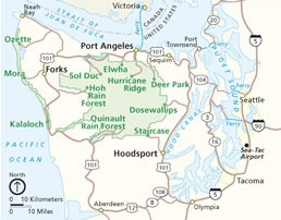
The Big Quilcene River is a river on the Olympic Peninsula in the U.S. state of Washington. It rises in the Buckhorn Wilderness near Marmot Pass, south of Buckhorn Mountain, and near Mount Constance. It flows generally east through the Olympic Mountains and the Olympic National Forest. After flowing south briefly the river is joined by Tunnel Creek and again flows east. It cuts through the Quilcene Range of the Olympic Mountains in which it collects a number of tributaries, including Mile And A Half Creek. Near Rainbow Campground the river turns north and is paralleled by U.S. Route 101. In its last few miles the river turns east and flows by the south side of Quilcene before emptying into Quilcene Bay, part of Hood Canal. The Little Quilcene River enters Quilcene Bay less than a mile to the north.
The Dungeness River is a 28-mile (45 km) long river located in the Olympic Peninsula in the U.S. state of Washington. It rises near Mount Constance in the Olympic Mountains within the Olympic National Park, flows through the Buckhorn Wilderness, passes by the town of Sequim, and empties into the Strait of Juan de Fuca at Dungeness Bay, behind the Dungeness Spit. One of its main tributaries is the Gray Wolf River. It is crossed by the Dungeness River Bridge.

The Elwha River is a 45-mile (72 km) river on the Olympic Peninsula in the U.S. state of Washington. From its source at Elwha snowfinger in the Olympic Mountains, it flows generally north to the Strait of Juan de Fuca. Most of the river's course is within the Olympic National Park.
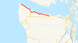
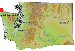
State Route 112 is a state highway and scenic byway in the U.S. state of Washington. It runs east–west for 61 miles (98 km) along the Strait of Juan de Fuca in Clallam County, connecting the Makah Indian Reservation near Neah Bay to U.S. Route 101 (US 101) near Port Angeles.

Discovery Bay is a small bay connected to the Strait of Juan de Fuca on the Olympic Peninsula in Washington state; it was also historically called Port Discovery. An unincorporated community also named "Discovery Bay" lies in Jefferson County at the southern end of the bay.
The Quimper Peninsula is a narrow peninsula forming the most northeastern extent of the Olympic Peninsula of Washington state in the northwestern United States of America.

Haro Strait, often referred to as the Haro Straits because it is really a series of straits, is one of the main channels connecting the Strait of Georgia to the Strait of Juan de Fuca, separating Vancouver Island and the Gulf Islands in British Columbia, Canada from the San Juan Islands of Washington state in the United States.

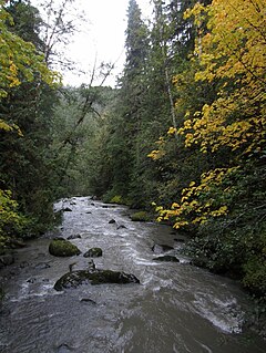
The Pysht River is a stream in the U.S. state of Washington. It originates near Ellis Mountain in the northern Olympic Mountains on the Olympic Peninsula and flows generally north, emptying into the Strait of Juan de Fuca. The Pysht and nearby Hoko River are the two largest streams flowing into the southwestern portion of the Strait of Juan de Fuca. The watershed of the Pysht River drains a region of industrial forest lands; 98% of the watershed is zoned commercial forestry and the remainder rural. Nearly all of the forests have been logged at least once and most trees are less than thirty years old. The upper portions of the watershed, which feature steep gradients, are owned by the United States Forest Service. The lower reaches, with low gradients, are largely owned by two industrial forest owners.
The East Twin River is a stream on the Olympic Peninsula in the U.S. state of Washington. It originates in the northern Olympic Mountains and flows north, emptying into the Strait of Juan de Fuca just east of West Twin River.
The West Twin River is a stream on the Olympic Peninsula in the U.S. state of Washington. It originates in the northern Olympic Mountains and flows north, emptying into the Strait of Juan de Fuca just east of East Twin River.
The Waatch River is a stream on the Olympic Peninsula in the U.S. state of Washington. It originates in the northwestern Olympic Mountains and empties into the Pacific Ocean. The name "Waatch" comes from the Makah village name /waʔač'/, said to mean "bundling up cedar to make a torch".

The Sooes River is a stream on the Olympic Peninsula in the U.S. state of Washington. It originates in the northwestern Olympic Mountains and empties into the Pacific Ocean.
The Ozette River is a stream on the Olympic Peninsula in the U.S. state of Washington. It originates in the northwestern Olympic Mountains and empties into the Pacific Ocean.
The Big River is a Big River on the Olympic Peninsula in the U.S. state of Washington. A principal tributary of the Ozette River, the Big River originates in the northwestern Olympic Mountains and empties into the Ozette Lake.

The Dickey River is a stream on the Olympic Peninsula in the U.S. state of Washington. It has three main forks, the East Fork, West Fork, and Middle Fork Dickey Rivers. The main stem is formed by the confluence of the East and West Forks. The river and its forks rise in the northwestern part of the Olympic Peninsula and flow generally south and west to join the Quillayute River near its mouth on the Pacific Ocean.

Protection Island National Wildlife Refuge is located near the mouth of Discovery Bay in the Strait of Juan de Fuca in Jefferson County, Washington. Approximately 70 percent of the nesting seabird population of Puget Sound and the Strait of Juan de Fuca nest on the island, which includes one of the largest nesting colonies of rhinoceros auklets in the world and the largest nesting colony of glaucous-winged gulls in Washington. The island contains one of the last two nesting colonies of tufted puffins in the Puget Sound area. About 1,000 harbor seals depend upon the island for a pupping and rest area.