Related Research Articles

Saguenay–Lac-Saint-Jean is a region in Quebec, Canada. It contains the Saguenay Fjord, the estuary of the Saguenay River, stretching through much of the region. It is also known as Sagamie in French, from the first part of "Saguenay" and the last part of "Piekouagami", the Innu name for Lac Saint-Jean, with the final "e" added to follow the model of other existing region names such as Mauricie, Témiscamie, Jamésie, and Matawinie. With a land area of 98,712.71 km2, Saguenay–Lac-Saint-Jean is the third-largest Quebec region after Nord-du-Québec and Côte-Nord.
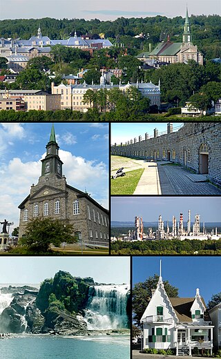
Lévis is a city in eastern Quebec, Canada, located on the south shore of the St. Lawrence River, opposite Quebec City. A ferry links Old Quebec with Old Lévis, and two bridges, the Quebec Bridge and the Pierre-Laporte Bridge, connect western Lévis with Quebec City.
Bellechasse Regional County Municipality is a regional county municipality in the Chaudière-Appalaches region of Quebec. The county seat is Saint-Lazare-de-Bellechasse.

Côte-Nord is a region of 247,655.33 square kilometres (95,620.26 sq mi), the second-largest administrative region in Québec Province, Canada, behind Nord-du-Québec. It covers much of the northern shore of the Saint Lawrence River estuary and the Gulf of Saint Lawrence past Tadoussac.
Mauricie is a traditional and current administrative region of Quebec. La Mauricie National Park is contained within the region, making tourism in Mauricie popular. The region has a land area of 35,860.05 km2 and a population of 266,112 residents as of the 2016 Census. Its largest cities are Trois-Rivières and Shawinigan.
The 2000–2006 municipal reorganization in Quebec resulted in large-scale amalgamation of smaller municipalities in Quebec into larger cities. It was undertaken by one administration, but was modified and partially undone by its successor.

Argenteuil—Papineau—Mirabel was a federal electoral district in Quebec, Canada, that was represented in the House of Commons of Canada from 1867 to 2015.
Montmorency was a federal electoral district in the province of Quebec, Canada, that was represented in the House of Commons of Canada from 1867 to 1917, and from 1968 to 2004.

The St. Francis River is a river roughly 75 miles (120 km) long, which forms part of the Canada–United States border. The river rises in a lake of the same name located 12 miles (20 km) east of the Rivière du Loup in Quebec. The portion that forms the boundary starts at the bottom of Lake Pohenegamook at the very northernmost point of New England between Estcourt Station, Maine, and Estcourt, Quebec. The river along the international boundary flows south and then south-east through two deep, narrow lakes to its mouth on the Saint John River at St. Francis, Maine/Saint-François-de-Madawaska, New Brunswick.

The municipal history of Quebec started in 1796 with the creation of administrations for Montréal and Quebec City, but it really developed immediately prior to the creation of the Province of Canada in 1841 with the formation of municipal districts, followed in March 1845 when the Parliament of the Province of Canada adopted an Act to create local authorities in Lower Canada which took effect in July 1845.

The Big Black River is a river crossing the administrative region of Chaudière-Appalaches in Quebec and in Maine. From its source, in L'Islet RCM, Quebec, the river runs northeast and east across the Canada–United States border in Maine Township 14, Range 16, WELS, to the Saint John River in Northwest Aroostook T 15, R 13.
The Daaquam River is a river primarily flowing in the administrative region of Chaudière-Appalaches, at South of Quebec in Canada and northern Maine, in United States. The river runs from its source, south of Sainte-Justine, northeast across the Canada–United States border to the Northwest Branch of the Saint John River in Maine.
The Shields Branch is a tributary of the Big Black River, flowing in:
The Southwest Branch Saint John River is a 62.0-mile-long (99.8 km) river in Maine and Quebec. The branch originates in "Little Saint John Lake" on the international boundary between Saint-Zacharie, Quebec and Seboomook Lake Township 5, Range 20, WELS. The branch forms the Canada–United States border as it flows northeasterly to a confluence with the Little Southwest Branch Saint John River in Seboomook Lake Township 9, Range 18, WELS. The Southwest Branch flows briefly into Quebec and then through Maine to its confluence with the Baker Branch Saint John River in Seboomook Lake Township 9, Range 17, WELS. The Southwest Branch finally joins with the Northwest Branch to form the Saint John River.
The West Branch Little Black River is a short river in Quebec and northern Maine.
The Otter River is a tributary of the Northwest Branch Saint John River, flowing in Quebec (Canada) and in Maine. This river crosses the following administrative territories:
The Brown River is a tributary of the Depot River, flowing in Quebec, Canada, in the municipality of Saint-Adalbert, in L'Islet Regional County Municipality, in the administrative region of Chaudière-Appalaches, and in Aroostook County, Maine, United States, in Township T13 R16 Wels, in the North Maine Woods. Its course runs entirely through forested region in a plain in Quebec and in a valley south of the Canada-US border.
The Gobeil River is a tributary of the Big Black River, flowing through: