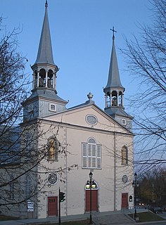
Saguenay is a city in the Saguenay–Lac-Saint-Jean region of Quebec, Canada, on the Saguenay River, about 200 kilometres (120 mi) north of Quebec City by overland route. It is about 126 kilometres (78 mi) upriver and northwest of Tadoussac, located at the confluence with the St. Lawrence River. It was formed in 2002 by merging the cities of Chicoutimi and Jonquière and the town of La Baie. Chicoutimi was founded by the French in 1676.

Longueuil is a city in the province of Quebec, Canada. It is the seat of the Montérégie administrative region and the central city of the urban agglomeration of Longueuil. It sits on the south shore of the Saint Lawrence River directly across from Montreal. The population as of the Canada 2016 Census totalled 239,700, making it Montreal's second largest suburb, the fifth most populous city in Quebec and twentieth largest in Canada.

Saguenay–Lac-Saint-Jean is a region in Quebec, Canada. It contains the Saguenay Fjord, the estuary of the Saguenay River, stretching through much of the region. It is also known as Sagamie in French, from the first part of "Saguenay" and the last part of "Piekouagami", the Innu name for Lac Saint-Jean, with the final "e" added to follow the model of other existing region names such as Mauricie, Témiscamie, Jamésie, and Matawinie. The name Saguenay is possibly derived from the Innu word "Saki-nip" which means "where water flows out". With a land area of 98,712.71 km2, the Saguenay–Lac-Saint-Jean is, after the Nord-du-Québec and Côte-Nord regions, the third-largest of Quebec regions in the area.

Victoriaville is a town in central Quebec, Canada, on the Nicolet River. Victoriaville is the seat of Arthabaska Regional County Municipality and a part of the Centre-du-Québec (Bois-Francs) region. It is formed by the 1993 merger of Arthabaska, Saint-Victoire-d'Arthabaska and Victoriaville, the name of the last being used for the merged town.

LaSalle is a borough (arrondissement) of the city of Montreal, Quebec, Canada. Prior to 2002, it was a separate municipality that had been incorporated in 1912. LaSalle is located in the south-west portion of the Island of Montreal, along the Saint Lawrence river.

Charlesbourg is a borough of Quebec City, in the northeastern part of the city, west of the borough of Beauport.

Amos is a town in northwestern Quebec, Canada, on the Harricana River. It is the seat of Abitibi Regional County Municipality.
Bellechasse was a federal electoral district in Quebec, Canada, that was represented in the House of Commons of Canada from 1867 until the 1997 election, when it became Bellechasse—Etchemins—Montmagny—L'Islet. After redistribution prior to the 2004 election, that riding became Lévis—Bellechasse. Currently, the only riding which includes the name "Bellechasse" is Bellechasse—Les Etchemins—Lévis.

Hérouxville is a parish municipality in the Mékinac Regional County Municipality in the administrative region of Mauricie, in the province of Quebec, Canada. Its watershed is mainly part of the Batiscanie.
Quebec County was a historic county in the province of Quebec, Canada. The county included the Quebec City metropolitan area and extended northwestward. The county seat was Loretteville.

Saint-Étienne-des-Grès is a parish municipality in the Mauricie region of the province of Quebec in Canada.

Causapscal is a city in the Canadian province of Quebec, located in La Matapédia Regional County Municipality. It is located at the confluence of the Matapédia and Causapscal Rivers, along Quebec Route 132, approximately halfway between Mont-Joli and Campbellton, New Brunswick. It is served by the Causapscal railway station and the Causapscal Airport.

Lac-au-Saumon is a municipality in the Canadian province of Quebec, located in La Matapédia Regional Council Municipality in the Matapédia Valley.
Saint-Gérard-des-Laurentides is a community in the Canadian province of Quebec. Formerly a separate parish municipality in the Le Centre-de-la-Mauricie Regional County Municipality, it has been one of the seven sectors of the city of Shawinigan since the municipal amalgamation of January 1, 2002.
Baie-de-Shawinigan is a small industrial community within the City of Shawinigan in the Canadian province of Quebec. The place is named after its location on a bay of the Saint-Maurice River. For a period of time, it was also known as Belgoville because it faced the paper mill of the Belgo Canadian Pulp Company.
The 2004 Quebec municipal referendums were held by the Quebec Liberal Party government of Jean Charest that came to power in the 2003 Quebec election, in fulfillment of a campaign promise to allow voters to have a say regarding the municipal reorganization program that had been undertaken by the preceding Parti Québécois administration.
The Radnor Township is located in the administrative region of Mauricie, in the province of Quebec, in Canada. Today, the administration of this territory is under the city of Shawinigan and Mekinac Regional County Municipality (RCM). Rectangular, the Canton is about 5 km wide and 38 km deep, oriented northwest to southeast. The central part of the township is in La Mauricie National Park, on the west bank of the Saint-Maurice River which cut diagonally this township. The southeastern part of the township includes the municipalities of Saint-Jean-des-Piles, Grandes-Piles, Saint-Roch-de-Mékinac, sector Lac-à-la-Tortue and Garneau railway junction.
The Lejeune Township is located in the MRC Mekinac Regional County Municipality, in Mauricie, Quebec, Canada.
The Communauté urbaine de Québec was a regional municipal body that existed in the area around Quebec City from 1970 to 2001.


