Saint John | |
---|---|
![]() | |
![]() Map of Barbados showing the Saint John parish | |
Coordinates: 13°10′N59°29′W / 13.167°N 59.483°W | |
Country | Barbados |
Government | |
• Type | Parliamentary democracy |
• Parliamentary seats | 1 |
Area | |
• Total | 34 km2 (13 sq mi) |
Population (2010 census) | |
• Total | 8,963 |
• Density | 260/km2 (680/sq mi) |
ISO 3166 code | BB-05 [1] |
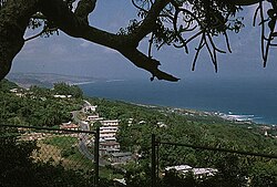
The parish of Saint John (St. John) is a parish of Barbados on the eastern side of the island. It is home to one of its secondary schools, The Lodge School and to the St. John's Parish Church. [2] In its southeastern corner the shoreline turns northward, forming the small Conset Bay. [3]
The parish contains the following towns, villages, localities, settlements, communities, and hamlets:
Bridgetown is the capital and largest city of Barbados. Formerly The Town of Saint Michael, the Greater Bridgetown area is located within the parish of Saint Michael. Bridgetown is sometimes locally referred to as "The City", but the most common reference is simply "Town". As of 2014, its metropolitan population stands at roughly 110,000.
The parish of St. Michael is one of eleven parishes of Barbados. It has a land area of 39 km2 (15 sq mi) and is found at the southwest portion of the island. Saint Michael has survived by name as one of the original six parishes created in 1629 by Governor Sir William Tufton.
Llantwit Major is a town and community in Wales on the Bristol Channel coast. It is one of four towns in the Vale of Glamorgan, with the third largest population after Barry and Penarth, and ahead of Cowbridge. It is 4+1⁄2 miles (7.2 km) from Cowbridge, 9 miles (14 km) from Bridgend, 10 miles (16 km) from Barry, and 15 miles (24 km) from Cardiff. It had a population of 9,530 in 2021.
The parish of Christ Church is one of eleven historic political divisions of Barbados. It has a land area of 57 km2 (22 sq mi) and is found at the southern end of the island. Christ Church has survived by name as one of the original six parishes created in 1629 by Governor Sir William Tufton.
Saint Andrew is one of eleven parishes of Barbados. It is situated in the northeastern area in the country.
The parish of Saint James is an area located in the western central part of the country of Barbados. Increasingly St. James is becoming known as the playground of the rich and famous, and as a haven for sun-starved tourists with its up-market hotel resorts.
The landlocked parish of Saint George is located in the interior of Barbados. It is one of two land-locked parishes, the other being Saint Thomas to the north. A prominent landmark in the parish is Gun Hill Signal Station – one of the few remaining signal stations, dating back to 1818.
The parish of Saint Lucy is the northernmost area in the country of Barbados. Saint Lucy is the only parish of Barbados out of the eleven to be named after a female patron saint, Saint Lucy of Syracuse. Saint Lucy's shape also resembles a peninsula, surrounded on three sides by the Atlantic Ocean to the north, east and west. The Harrison Point Lighthouse is located in Harrisons, Saint Lucy between Great Head and Norse's Bay, also in Saint Lucy. To the south lies the neighbouring Parish of Saint Peter.
The Parish of Saint Peter is one of eleven parishes in the Caribbean island country of Barbados. It is named after the Christian Apostle and patron saint, Saint Peter. It is located in the north of Barbados, and is the only parish besides Saint Lucy that extends from the east coast to the west.
The landlocked parish of Saint Thomas is found in the centre of Barbados. It is one of only two landlocked parishes in the island, the other being Saint George to the south.
Saint Philip is a parish of Barbados at the easternmost end of the island. Saint Philip’s Parish Church was built as the Anglican parish church in 1640.
Saint John Figtree is one of five administrative parishes which make up the small Caribbean island of Nevis. These five parishes are part of the fourteen parishes that exist within the Federation of Saint Kitts and Nevis, a two-island country in the Leeward Islands, Lesser Antilles, West Indies.
The following is an alphabetical list of topics related to the nation of Barbados.
Hellaby is a village and civil parish in the Metropolitan Borough of Rotherham, South Yorkshire, England. The population of the civil parish at the 2011 census was 825. It is situated 5 miles (8.0 km) east from the centre of Rotherham and forms a continuous urban area with Maltby, separated from the rest of Rotherham by Junction 1 of the M18. It is situated by Hellaby Brook and, whilst signposted as "Hellaby Village", the parish has no school, church or post office.
The Barbados Transport Board (BTB) is a public transportation authority of the government of Barbados. The BTB operates numerous fixed-route bus lines service through much of the country. The BTB's headquarters are located at Weymouth, Roebuck Street, area while the main terminal is at Fairchild Street in Saint Michael.
Balaclava is a small town in Northern St Elizabeth parish, Jamaica. It used to be an important town in the north of the parish.
Meeting House Hill is one of the oldest sections of Boston's historic Dorchester neighborhood. It is the site of the First Parish Church and the Mather School, the oldest public elementary school in North America. Located immediately to the north of Fields Corner, it is within walking distance of the Fields Corner and Savin Hill MBTA stations.
Saint John is a constituency in the Saint John parish of Barbados. It was established in 1645 as one of the original eleven constituencies. Originally the constituency, like the other original ten, was represented by 2 members until 1971 when the single-member system was introduced. Since 2018, it has been represented in the House of Assembly of the Barbadian Parliament by Charles McDonald Griffith. Griffith is a member of the BLP.