
Saguenay Fjord National Park is a provincial park located in Quebec, Canada. In the regions of Saguenay–Lac-Saint-Jean, Charlevoix, Côte-Nord, and Bas-Saint-Laurent, the park is situated along the eastern end of the Saguenay River and adjoins the Saguenay–St. Lawrence Marine Park for over 100 km (60 mi.).

Mont-Valin is an unorganized territory in the Canadian province of Quebec. It makes up over 87% of Le Fjord-du-Saguenay Regional County Municipality and is the largest subdivision of the Saguenay–Lac-Saint-Jean region. The territory, named after Mount Valin, had a population of 10 as of the Canada 2021 Census, and covered a land area of 33,540.39 km2.
The ZEC Chauvin is a "zone d'exploitation contrôlée" of 619 square kilometres (239 sq mi), located partly in the unorganized territory of the Mont-Valin, in Le Fjord-du-Saguenay Regional County Municipality, in the administrative region Saguenay-Lac-Saint-Jean, in Quebec, in Canada.
The Zec Martin-Valin is a "zone d'exploitation contrôlée" (ZEC), located in the Le Fjord-du-Saguenay Regional County Municipality, in administrative region of Saguenay-Lac-Saint-Jean, in Quebec, in Canada.
The ZEC Onatchiway is a "zone d'exploitation contrôlée" (zec) of 1,462 square kilometres (564 sq mi), located in the unorganized territory of Mont-Valin, in the Le Fjord-du-Saguenay Regional County Municipality, in the administrative region Saguenay-Lac-Saint-Jean, in Quebec, in Canada.
The ZEC de la Rivière-Sainte-Marguerite is a "zone d'exploitation contrôlée" (ZEC) in the unorganized territory of the Mont-Valin, in Le Fjord-du-Saguenay Regional County Municipality, in the administrative region of Saguenay-Lac-Saint-Jean, Quebec, Canada.
Zec de la Rivière-Petit-Saguenay is a "zone d'exploitation contrôlée" (zec) located in the municipality of Petit-Saguenay, in Le Fjord-du-Saguenay Regional County Municipality, in administrative region of Saguenay–Lac-Saint-Jean, in Quebec, in Canada.
Lake Péribonca is a freshwater body of the unorganized territory of Mont-Valin, Quebec, in Le Fjord-du-Saguenay Regional County Municipality, in the administrative region of Saguenay-Lac-Saint-Jean, in Quebec, Canada.
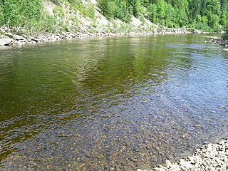
The Sainte-Marguerite River Old Forest is a protected area of old-growth forest in the Saguenay–Lac-Saint-Jean and Côte-Nord regions of Quebec, Canada. It is classified as an exceptional forest ecosystem. It protects an area on the northeast bank of the Sainte-Marguerite River.
The Saint-Jean River is a river crossing the municipalities of Rivière-Éternité and L'Anse-Saint-Jean in the Le Fjord-du-Saguenay Regional County Municipality, in the administrative region of Saguenay-Lac-Saint-Jean, Quebec, Canada.
The bras des Canots is a tributary of the Valin River, flowing in the unorganized territory of Mont-Valin, in the Le Fjord-du-Saguenay Regional County Municipality, in the administrative region of Saguenay-Lac-Saint-Jean, in Quebec, in Canada. The course of the Bras des Canots flows mainly in the Monts-Valin National Park.
The Moncouche Lake is a freshwater body of the watershed of the rivière aux Sables, flowing in the unorganized territory of Mont-Valin, in the Le Fjord-du-Saguenay Regional County Municipality, in the administrative region of the Saguenay–Lac-Saint-Jean, in the province of Quebec, in Canada. Most of the area is included in the northwestern part of the territory of zec Martin-Valin, in the township of Garreau. Forestry is the main economic activity in the sector. Recreational and tourist activities come second.
The Bras du Nord is a tributary of the Valin River, flowing in the unorganized territory of Mont-Valin and in the municipality of Saint-David-de-Falardeau, in the Le Fjord-du-Saguenay Regional County Municipality, in the administrative region of Saguenay–Lac-Saint-Jean, in Quebec, in Canada. The course of the Bras du Nord flows in the canton of Falardeau.
The Brûlée River is a tributary of the Portneuf River, flowing on the northwest shore of the Saint Lawrence River, in the Province of Quebec, in Canada. The course of this river crosses the administrative regions of:
The Rivière aux Outardes is a tributary of the Saguenay River, flowing in the municipality of Saint-Fulgence, in the Le Fjord-du-Saguenay Regional County Municipality, in the administrative region of Saguenay-Lac-Saint-Jean, in the province of Quebec, in Canada.
The Saint-Louis River is a tributary of the Valin River, flowing on the northwest shore of the Saint Lawrence River, in the unorganized territory of Mont-Valin and the municipality of Saint-David-de-Falardeau, in the Le Fjord-du-Saguenay Regional County Municipality, in the administrative region of Saguenay-Lac-Saint-Jean, in the Province of Quebec, in Canada.

The Valin River is a tributary of the Saguenay River, flowing successively in the unorganized territory of Valin Mountains, in Saint-David-de-Falardeau and Saint-Fulgence, in the Le Fjord-du-Saguenay Regional County Municipality, in the administrative region of Saguenay-Lac-Saint-Jean, in the Province of Quebec, in Canada.
Lac Martin-Valin is a freshwater body of the watershed of bras des Canots, located on the north shore of the St. Lawrence River, in the unorganized territory of Mont-Valin, in the Le Fjord-du-Saguenay Regional County Municipality, in the administrative region of the Saguenay-Lac-Saint-Jean, in the province of Quebec, Canada.
The rivière à la Loutre is a tributary of the Saguenay River, flowing in the municipality of Saint-Fulgence in the Le Fjord-du-Saguenay Regional County Municipality, in the administrative region of Saguenay-Lac-Saint-Jean, in Quebec, in Canada.

La Vallée-de-la-Rivière-Sainte-Marguerite Biodiversity Reserve, up to 2022 known as Réserve Aquatique de la Vallée-de-la-Rivière-Sainte-Marguerite, is a biodiversity reserve in Quebec (Canada), located in the Saguenay-Lac-Saint-Jean and Côte-Nord regions. This 321 km2 protected area is dedicated to conserving the ecosystems of the Sainte-Marguerite River valley. The latter is located in a glacial valley separating the Saguenay Graben from the Monts Valin. The proximity of these two physiographic units favors the diversity of the flora, with several species at the northern limit of their range.

