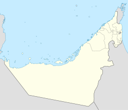
The United Arab Emirates is a country in the eastern part of the Arabian Peninsula located on the southeastern coast of the Persian Gulf and the northwestern coast of the Gulf of Oman. The UAE consists of seven emirates and was founded on 2 December 1971 as a federation. Six of the seven emirates combined on that date. The seventh, Ras al Khaimah, joined the federation on 10 February 1972. The seven sheikdoms were formerly known as the Trucial States, in reference to the treaty relations established with the British in the 19th Century.

The Emirate of Fujairah is one of the seven emirates that make up the United Arab Emirates. The only of the seven with a coastline solely on the Gulf of Oman and none on the Persian Gulf, its capital is Fujairah.

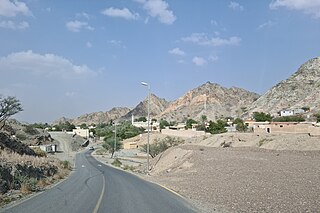
Khatt is a mountainous village south-east of the city of Ras Al Khaimah, United Arab Emirates. Famous for its hot springs, and latterly home to a spa hotel, there is evidence that Khatt has been a site of constant human settlement since the stone age – a record of over 5,000 years of occupation.
Jabal Hafeet is a mountain in the region of Tawam, on the border of the United Arab Emirates and Oman, which may be considered an outlier of Al Hajar Mountains in Eastern Arabia. Due to its proximity to the main Hajar range, the mountain may be considered as being part of the Hajar range, sensu lato. To the north is the UAE city of Al Ain, in the Eastern Region of the Emirate of Abu Dhabi, and the adjacent Omani town of Al-Buraimi.

Al Qurayyah is a village in the Emirate of Fujairah, in the United Arab Emirates, some 14km north of the city of Fujairah. It is associated with the Kaabi family. In 2016, construction work on a mosque revealed the existence of a Wadi Suq Period burial site, which has been preserved by the Fujairah Tourism and Antiquities Authority.

Shimal is the name of a settlement in Ras Al Khaimah, United Arab Emirates. It is associated with the Shihuh tribe of the Northern UAE and Oman and with the foundation of the Islamic era port of Julfar, and was once the seat of the Ruler of Julfar. It is also the location of an important archaeological site dating back to the Umm Al Nar culture.

Wadi Wurayah is a 12,700-hectare (31,000-acre) wadi between the towns of Masafi, Khor Fakkan, and Bidiyah in the United Arab Emirates. It has been designated as Ramsar Wetland of International Importance.

Tell Abraq(Til Abrook) was an ancient Near Eastern city. Located on the border between Sharjah and Umm Al Quwain in the United Arab Emirates, the city was originally on the coastline of the Persian Gulf but changing sea levels have placed the remains of the city inland. It is located on the main road from Umm Al Quwain to Falaj Al Mualla.
Bithnah is a village in Fujairah, United Arab Emirates (UAE), long occupying a strategic location in the Wadi Ham, which is the only natural link to the interior of the UAE and the Persian Gulf from the East Coast city, and Emirate of Fujairah.

The Wadi Suq culture defines human settlement in the United Arab Emirates and Oman in the period from 2,000 to 1,300 BCE. It takes its name from a wadi, or waterway, west of Sohar in Oman and follows on from the Umm al-Nar culture. Although archaeologists have traditionally tended to view the differences in human settlements and burials between the Umm Al Nar and Wadi Suq periods as the result of major external disruption, contemporary opinion has moved towards a gradual change in human society which is centred around more sophisticated approaches to animal husbandry as well as changes in the surrounding trade and social environments.
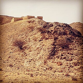
Jebel Buhais or Jebel Al-Buhais is a geological feature, an extensive rocky outcrop, as well as an archaeological site located near Madam in the central region of the Emirate of Sharjah, the UAE, about 48 kilometres southeast of the city of Sharjah. The area contains an extensive necropolis, consisting of burial sites spanning the Stone, Bronze, Iron and Hellenistic ages of human settlement in the UAE. Burials at Jebel Buhais date back to the 5th Millennium BCE. The site is located to the side of a limestone outcrop rising to some 340 metres above sea level and which runs almost contiguously from the town of Madam north to the town of Mleiha, itself an important archaeological site.
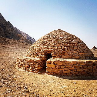
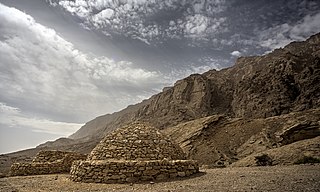
The Hafit period defines early Bronze Age human settlement in the United Arab Emirates and Oman in the period from 3200 to 2600 BC. It is named after the distinctive beehive burials first found on Jebel Hafit, a rocky mountain near Al Ain, bordering the Rub Al Khali desert. Hafit period tombs and remains have also been located across the UAE and Oman in sites such as Bidaa bint Saud, Jebel Al-Buhais and Buraimi.
Fujairah Free Zone (FFZ) is a special economic zone in Fujairah, which is one of the seven emirates that comprise the United Arab Emirates. Fujairah Free Zone is located just north of the emirate's capital, Fujairah City. It is run by the Fujairah Free Zone Authority (FFZA).

Qattara Oasis is an area of irrigated date farm in Al Ain, United Arab Emirates featuring a distinctive falaj irrigation system as well as a late Bronze Age archaeological site dated to 1800–1500 BCE. The oasis has been extensively surveyed by students from Al Ain University since 2015, and is home to 19 buildings of varying antiquity, of which nine are mosques. Among these are thought to be some of the oldest buildings still standing in Al Ain.
The UAE's Iron Age I spanned 1,200–1,000 BCE; Iron Age II, 1,000–600 BCE and Iron Age III from 600–300 BCE. This was followed by the Hellenistic Mleiha era, from 300 BCE onwards through to the Islamic era which commenced with the culmination of the 7th century Ridda Wars.
The territory currently known as the United Arab Emirates was home to three distinct Iron Age periods. Iron Age I spanned 1,200–1,000 BCE, Iron Age II from 1,000–600 BCE, and Iron Age III from 600–300 BCE. This period of human development in the region was followed by the Mleiha or Late Pre-Islamic era, from 300 BCE onwards through to the Islamic era which commenced with the culmination of the 7th century Ridda Wars.

'En Esur, also En Esur or Ein Asawir is an ancient site located on the northern Sharon Plain, at the entrance of the Wadi Ara pass leading from the Coastal Plain further inland. The site includes an archaeological mound (tell), called Tel Esur or Tell el-Asawir, another unnamed mound, and two springs, one of which gives the site its name. During the Early Bronze Age, around 3000 BCE, a massive fortified proto-city with an estimated population of 5,000 to 6,000 inhabitants existed there. It was the largest city in the region, larger than other significant sites such as Megiddo and Jericho, but smaller than more distant ones in Egypt and Mesopotamia. The city was discovered in 1977, but its massive extent was realized only in 1993. A major excavation between 2017 and 2019 ahead of the construction of a highway interchange exposed the city's houses, streets and public structures, as well as countless artifacts including pottery, figurines and tools. Archaeologists announced its discovery in 2019, calling it the "New York of the Early Bronze Age".
Wadi Saham is a seasonal watercourse in the Hajar Mountains of Fujairah, in the United Arab Emirates. It is notable for its petroglyphs, including a single rock bearing 26 petroglyphs across four faces.
Wadi Helo is a seasonal watercourse located in the Hajar Mountains of Sharjah, in the United Arab Emirates. The wadi runs northwest to southeast of the eponymous village of Wadi Helo, located on the Sharjah-Kalba highway.
Tayyibah is a large village in the Hajar Mountains of Fujairah, United Arab Emirates. It is notable for its hiking trails, its Heritage Museum and the Al Qalaa Lodge, an Emirati heritage themed guest house.