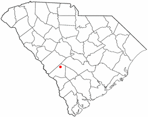
Elko is a town in Barnwell County, South Carolina, United States. According to the 2010 census the population was 193.

Dindori District, formerly known as Ramgarh District, is a district of Madhya Pradesh state of central India. The town of Dindori is the district headquarters. The district is part of Jabalpur Division. Total area of the district is 6,128 km2 (2,366 sq mi). It is located on the eastern part of Madhya Pradesh, bordering the state of Chhattisgarh. It is surrounded by Anuppur district to the northeast, Umaria district to the north, Jabalpur district to the west, Mandla district to the southwest and Mungeli and Kabirdham districts of Chhattisgarh to the south.
Hansapur is a small town in Arghakhanchi District in the Lumbini Zone of southern Nepal. At the time of the 1991 Nepal census, the town had a population of 7407 living in 1458 houses. At the time of the 2001 Nepal census, the population was 8103, of which 53% was literate.
Devisthan is a village development committee in Baglung District in the Dhaulagiri Zone of central Nepal. At the time of the 1991 Nepal census it had a population of 6,151 and had 1247 houses in the town.
Kadel is a village in Bajhang District in the Seti Zone of north-western Nepal. At the time of the 1991 Nepal census it had a population of 3,816 and had 693 houses in the village.
Bichhiya is a village in Bajura District in the Seti Zone of north-western Nepal. At the time of the 1991 Nepal census it had a population of 1,904 and had 352 houses in the village.

Kanda, Bajura is a village in Bajura District in the Seti Zone of north-western Nepal. At the time of the 1991 Nepal census it had a population of 2,741 and had 484 houses in the village.
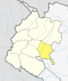
Indrapur is a town in Banke District in Lumbini Province of south-western Nepal. At the time of the 1991 Nepal census it had a population of 5,403 and had 1056 houses in the town. It had been a part of Nepalgunj sub-metropolitan city while expansion of municipality in to sub metropolitan city. However, this part of Sub-metropolitan city was structured under Janaki Rural Municipality.
Khajura Khurda is a town in Banke District in the Bheri Zone of south-western Nepal. At the time of the 1991 Nepal census it had a population of 4,508 and had 831 houses in the town.
Paraspur is a village development committee in Banke District in Lumbini Province of south-western Nepal. At the time of the 1991 Nepal census it had a population of 3,201 and had 604 houses in the town. Now, it is a part of Nepalgunj sub-metropolitan city.
Mahamadpur is a Village Development Committee in Bardiya District in Lumbini Province of south-western Nepal. At the time of the 1991 Nepal census it had a population of 8,191 and had 1152 houses in the town.
Manakamana is a former village development committee in Gorkha District in the Gandaki Zone of northern-central Nepal. At the time of the 1991 Nepal census it had a population of 5,083 and had 889 houses in the town.
Siseni is a town and municipality in Gulmi District in the Lumbini Zone of central Nepal. At the time of the 1991 Nepal census it had a population of 3851 persons living in 720 individual households.
Chhata Pipra is a town in Gadhimai Municipality in Bara District in the Narayani Zone of south-eastern Nepal. The formerly Village Development Committee was merged to form new municipality on 18 May 2014. At the time of the 2011 Nepal census it had a population of 7,175 persons living in 1,065 individual households. There were 3,674 males and 3,501 females at the time of census.
Kakadi is a town and Village Development Committee in Bara District in the Narayani Zone of south-eastern Nepal. At the time of the 1991 Nepal census it had a population of 2,808 persons living in 482 individual households.
Kadamandau is a village development committee in Doti District in the Seti Zone of western Nepal. At the time of the 1991 Nepal census it had a population of 3084 living in 609 individual households.
Pokhari is a Village Development Committee in Doti District in the Seti Zone of western Nepal. At the time of the 1991 Nepal census it had a population of 2968 residing in 632 individual households.
Rangapur is a village development committee in Rautahat District in the Narayani Zone of south-eastern Nepal. At the time of the 1991 Nepal census it had a population of 8141 people living in 1487 individual households.
Santpur is a town and market center in Chandrapur Municipality in Rautahat District in the Narayani Zone of south-eastern Nepal. The formerly village development committee was merged to form the municipality on 18 May 2014. At the time of the 1991 Nepal census it had a population of 5594.