
Leka is a municipality in Trøndelag county, Norway. It is part of the Namdalen region. The administrative centre of the municipality is the village of Leknes on the island of Leka. Other villages in Leka include Sør-Gutvika and Madsøygrenda. The island municipality includes all of the island of Leka and part of the island of Austra as well as hundreds of smaller surrounding islands and skerries.
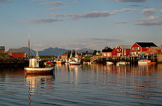
Vega is a municipality in Nordland county, Norway. It is part of the Helgeland traditional region. The administrative centre of the municipality is the village of Gladstad. Other villages include Holand and Ylvingen.
Hattfjelldal is a municipality in Nordland county, Norway. It is part of the Helgeland traditional region. The administrative centre of the municipality is the village of Hattfjelldal. Other villages include Grubben, Svenskvollen, and Varntresk. Hattfjelldal Airfield is located in the village of Hattfjelldal.

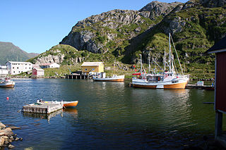
Fauske (Norwegian) or Fuossko (Lule Sami) is a municipality located in Nordland county, Norway. It is part of the traditional district of Salten. The administrative centre of the municipality is the town of Fauske. Some of the villages in Fauske include Nystad, Venset, Straumsnes, and Sulitjelma.

Hamarøy (Norwegian) or Hábmer (Lule Sami) is a municipality in Nordland county, Norway. It is part of the traditional district of Salten. The administrative centre of the municipality is the village of Oppeid. Other villages include Innhavet, Karlsøy, Presteid, Skutvika, Tømmerneset, Tranøy, and Ulvsvåg.
Bø is a municipality in Nordland county, Norway. It is part of the Vesterålen region. The administrative centre of the municipality is the village of Straume. Other villages in the municipality include Auvåg, the village of Bø, Eidet, Guvåg, Hovden, Klakksjorda, Malnes, Nykvåg, Utskor, and Vågen. The Litløy Lighthouse is located on the tiny island of Litløya off the coast of Bø.
Rana is a municipality in Nordland county, Norway. It is part of the Helgeland traditional region. The administrative centre of the municipality is the town of Mo i Rana, which houses the National Library of Norway. Other population centers in Rana include Alterneset, Båsmoen, Dunderland, Eiteråga, Flostrand, Hauknes, Mæla, Myklebustad, Nevernes, Røssvoll, Selfors, Skonseng, Storforshei, Utskarpen, and Ytteren.

Rognan is a village and the administrative centre of the municipality of Saltdal in Nordland county, Norway. The village is located at the innermost part of Skjerstad Fjord, called Saltdal Fjord. It is located about 15 kilometres (9.3 mi) north of the village of Røkland.

Balvatnet (Norwegian) or Bállávrre (Lule Sami) is a lake that lies in the municipality of Saltdal in Nordland county, Norway. The 41.46-square-kilometre (16.01 sq mi) lake is located on the border of Junkerdal National Park, about 2 kilometres (1.2 mi) west of the border with Sweden. The lake is regulated for hydroelectric power at the Daja Hydroelectric Power Station 16 kilometres (9.9 mi) to the north in Sulitjelma.

Kjelvatnet (Norwegian) or Giebbnejávrre or Giebnejávri (Lule Sami) is a lake in Fauske Municipality in Nordland county, Norway. The 3.85-square-kilometre (1.49 sq mi) lake lies about 7 kilometres (4.3 mi) south of the village of Sulitjelma near the border with Junkerdal National Park. Water flows into the lake from the large lake Balvatnet and it flows out of the lake to the north along the Balmi River to the lake Langvatnet.

Røkland is a village in the municipality of Saltdal in Nordland county, Norway. The village is located along the Saltdalselva river about 15 kilometres (9.3 mi) south of the municipal centre of Rognan. European route E06 and the Nordland Line both pass through the village. Røkland Station is a train station along the Nordland Line.
Lønsdal is a village in the municipality of Saltdal in Nordland county, Norway. The village is located in the Lønsdal valley, along the Lønselva river. European route E06 highway and the Nordland Line both pass through the village. The village also has a train station on the Nordland Line, about halfway between Dunderland Station and Røkland Station.
Bernhoff Otelius Hansen was a Norwegian wrestler who competed in the 1904 Summer Olympics for the United States.
Hyllestad quernstone quarries in the county of Sogn og Fjordane represent the oldest and one of the largest production areas for quernstones and millstones in Norway with approx. 400 quarries identified. The natural condition for the quernstone and millstone production in the area is the rock type garnet mica schist. The quarries are located from the shoreline up until approx. 200 m above sea level, but a majority is situated less than one kilometer from the sea and closest harbor. The quarries are well preserved, visible and most of them are easily accessible. In the Viking period and the Middle Ages, quernstones were shaped and carved directly from the bedrock, and in several of the quarries unfinished quernstones and millstones are still attached to the rock. The large scale production has since Viking times led to severe changes of the landscape. Quarries and spoil heaps are so densely situated that the original topography is not visible anymore. Two harbors are also identified. Here, large amounts of quern and millstones as well as ballast stones are located on the sea bed, testifying to the activity of loading and unloading that once took place here. From the 1600s, the production in Hyllestad started to decrease. In Early Modern period a new technology came into use in the quarries – the use of gunpowder. This production lasted until 1930. Thus, the quernstone quarries in Hyllestad represent an approx. 1200 years old history.

Rognan Airport is a private airport situated in the village of Rognan in the municipality of Saltdal in Nordland county, Norway. The municipal airport features a 735-meter (2,411 ft) grass runway aligned 01/19. It is used for recreational flying and is operated by Saltdal Flyklubb.
Langset is a basic statistical unit in the sub-area of Nedre Saltdal in the municipality of Saltdal in Nordland county, Norway. The area is located north of Rognan and Saksenvik and south of Setså on the east side of Saltdal Fjord (Saltdalsfjorden). European route E6 and the Nordland Line pass through the area.
The Balmi River is a river in the municipality of Fauske in Nordland county, Norway. It flows about 6.5 km (4.0 mi) from one lake and empties into another: from Kjelvatnet at an elevation of 510 meters (1,670 ft) north to Langvatnet at an elevation of 127 meters (417 ft). The river has a drainage basin of 439 square kilometers (169 sq mi). The river is located a short distance south of the village of Sulitjelma and about 35 kilometres (22 mi) southeast of the Fauske.

Skjerstad is a former municipality in Nordland county, Norway. The 465-square-kilometre (180 sq mi) municipality existed from 1838 until its dissolution in 2005. The municipality generally encompassed the area around the Misværfjorden in what is now Bodø Municipality, although it originally was much larger, also including the entire present-day Fauske Municipality. The administrative centre of Skjerstad municipality was the village of Misvær.


