Saksun | |
|---|---|
Village | |
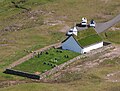
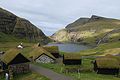
 View of Saksun from the lake | |
 Saksun Location in the Faroe Islands | |
| Coordinates: 62°14′56″N7°10′33″W / 62.24889°N 7.17583°W | |
| State | |
| Constituent country | |
| Island | Streymoy |
| Municipality | Sunda |
| Population (1 January 2006) | |
• Total | 9 |
| Time zone | GMT |
| • Summer (DST) | UTC+1 (EST) |
| Postal code | FO 436 |
| Climate | ET |
Saksun is a village near the northwest coast of the Faroese island of Streymoy, in Sunda Municipality.