
The Faroe Islands is served by an internal transport system based on roads, ferries, and helicopters. As of the 1970s, the majority of the population centres of the Faroe Islands have been joined to a single road network, connected by bridges and tunnels.

Hósvík is a village in the Faroe Islands. It has a population of 324 and is located on a bay on Streymoy's east-coast.

Streymoy is the largest and most populated island of the Faroe Islands. The capital, Tórshavn, is located on its southeast coast. The name means "island of currents". It also refers to the largest region of the country that also includes the islands of Hestur, Koltur and Nólsoy.

Eysturoy is a region and the second-largest of the Faroe Islands, both in size and population.

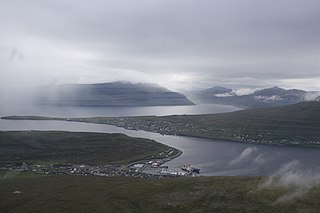
Runavík is a comparatively urbanised village in Runavík Municipality, Faroe Islands. It lies on the south half of the isle of Eysturoy.

Strandfaraskip Landsins is the government agency for public transport in the Faroe Islands. It is owned by the Faroese national government under the Ministry of Finance (Fíggjamálaráðið) and runs seven ferry routes and a number of bus routes.

Tjørnuvík is the northernmost village on Streymoy in Sunda Municipality, Faroe Islands. As of the 2006 census, the population has a total of 71 people.
Oyrarbakki is a village on the west coast of the Faroese island of Eysturoy in the Sunda municipality, between Norðskáli and Oyri.

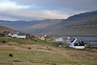
Oyri is a village on the central west coast of the Faroese island Eysturoy in the Sunda municipality.
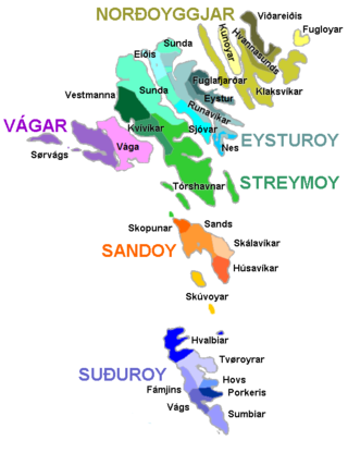
The Faroe Islands are administratively divided in 29 municipalities (kommunur), with about 120 cities and villages. Until December 31, 2008, there were 34 municipalities, and until December 31, 2004, there were 48 municipalities. In the coming years the number of Faroese municipalities is expected to drop to somewhere between 7 and 15, as there is currently a rationale towards municipal amalgamation and a decentralization of public services. In 1998 it was suggested that no municipality should have fewer than 2,000 inhabitants, but whether this will be true is a political question. The Faroese government has furthermore decided not to conduct forced, top-down amalgamation, but to leave the process to the free will of the municipalities. In many small municipalities there is some resistance to the amalgamation process, and as a result two kinds of municipalities are being created: large municipalities (town-municipalities) that are eager to attract smaller municipalities into amalgamation, and small municipalities which are either trying to avoid amalgamation or seek to amalgamate with other small municipalities. The geographically large Sunda municipality is an example of this. The larger municipalities are organized in Kommunusamskipan Føroya (KFS) and the smaller are organized in Føroya Kommunufelag (FKF).

Skálafjørður is a fjord in Eysturoy and the longest in the Faroe Islands.

Eysturoyartunnilin is a large undersea road tunnel under the Tangafjørður sound in the Faroe Islands, connecting the island of Streymoy to the island of Eysturoy. It also crosses the southern part of Skálafjørður, and connects the towns of Runavík on the eastern side and Strendur on the western side of the fjord, and includes the world's first undersea roundabout in the middle of the network.
A stevna is a regional summer festival in the Faroe Islands, usually accompanied by or built around national rowing boat championships. The races and regattas are always held on Saturdays, except the Ólavsøka race in the capital of Tórshavn, which has a fixed date. There are seven official rowing-related stevnur:

Sandoyartunnilin is an undersea road tunnel in the Faroe Islands. It connects the main island of Streymoy with Sandoy to the south. The length of the tunnel is 10.8 kilometres (6.7 mi) and the estimated cost is 860 million DKK. The tunnel opened for traffic on 21 December 2023, after which the ferry Teistin ceased its route between Gamlarætt on Streymoy and Skopun on Sandoy. The tunnel crosses the Skopunarfjørður and runs from Gamlarætt to Traðardalur in central Sandoy, near the Inni í Dal stadium.

Eiði Municipality is a municipality of the Faroe Islands. It is part of the Eysturoy region, and consists of a northwesterly part of the Eysturoy island. The municipality borders Runavík Municipality to the east and Sunda Municipality to the south and east. The population of the municipality is 810 (2023). The mayor of the municipality is Rógvi Egilstoft, and the municipal council consists of seven members elected every four years.

The Streymin Bridge, is an important highway bridge in the Faroe Islands. It connects the two biggest and most populous islands of Streymoy to the west and Eysturoy to the east. Crossing the Sundini sound at its narrowest point, it is jokingly referred to as the 'Bridge over the Atlantic', being the only inter-island bridge in the Faroe Islands, and one of the few such bridges in the Atlantic Ocean.

Sundini is the northern section of the sound separating the islands of Streymoy and Eysturoy in the Faroe Islands. The southern section of the strait is named Tangafjørður.
Tangafjørður is the southern part of the strait separating the islands of Streymoy and Eysturoy in the Faroe Islands. The northern part of the strait between is named Sundini.
The Faroe Islands consist of 18 islands, several of which are deeply incised by fjords.


