Langasandur

Last updated

Langasandur
Village
Faroe Islands, Streymoy, Langasandur (03).jpg
Langasandur (seen from the north)
Faroe Islands location map.svg
Red pog.svg
Langasandur
Location in the Faroe Islands
Coordinates: 62°14′14″N7°3′13″W / 62.23722°N 7.05361°W / 62.23722; -7.05361
StateFlag of Denmark (state).svg  Kingdom of Denmark
Constituent countryFlag of the Faroe Islands.svg  Faroe Islands
Island Streymoy
Municipality Sunda kommuna
Population
 (2012)
  Total43
Time zone GMT
  Summer (DST) UTC+1 (EST)
Postal code
FO 438
Climate Cfc

Langasandur (Danish : Langesand) is a village located on the Faroese island of Streymoy in the municipality of Sunda.

Contents

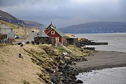
The village was settled in 1938, the name Langasandur means Longbeach.

Whaling station

Langasandur with its beach Faroe Islands, Streymoy, Langasandur (01).jpg
Langasandur with its beach

In 1894, the first whaling station in the Faroe Islands, was built at Gjánoyri, about 1 km south of the village. It was constructed by the Norwegian Hans Albert Grøn from Sandefjord, he sailed one of his decommissioned whaling stations from Finnmarken, and set it up in Gjánoyri, and started whaling with his boat Urd. [1]

The first whaling season, lasted from 24 June, when the first whale was shot, to 9 September when Grøn returned to Norway with 940 barrels of whale oil, and 5 tonnes of baleen, 46 whales were shot. [2]

In 1901, Grøn built the first industrial factory in the country, it was located right next to the whaling station, and produced bone meal to increase earnings from the whales, which before, only gave whale oil, and almost free whale meat to the locals.

The station closed down in 1925. [3]

The boats connected to the station were: Urd (1894-1911), Skuld (1897-1911), Funding (1914), Leif (1914), Dominion I (1920) and Norman I (1920) [4]

See also

Related Research Articles

<span class="mw-page-title-main">Transport in the Faroe Islands</span> Internal transport system of the Faroe Islands

The Faroe Islands is served by an internal transport system based on roads, ferries, and helicopters. As of the 1970s, the majority of the population centres of the Faroe Islands have been joined to a single road network, connected by bridges and tunnels.

<span class="mw-page-title-main">Grytviken</span> Place in South Georgia and the South Sandwich Islands, United Kingdom

Grytviken is a settlement on South Georgia in the South Atlantic and formerly a whaling station and the largest settlement on the island. It is located at the head of King Edward Cove within the larger Cumberland East Bay, considered the best harbour on the island. The location's name, meaning "pot bay", was coined in 1902 by the Swedish Antarctic Expedition and documented by the surveyor Johan Gunnar Andersson, after the expedition found old English try pots used to render seal oil at the site. Settlement was re-established on 16 November 1904 by Norwegian Antarctic explorer Carl Anton Larsen on the long-used site of former whaling settlements.

<span class="mw-page-title-main">Whaling in the Faroe Islands</span> Faroese drive hunting of whales and dolphins

Whaling in the Faroe Islands, or grindadráp, is a type of drive hunting that involves herding various species of whales and dolphins, but primarily pilot whales, into shallow bays to be beached, killed, and butchered. Each year, an average of around 700 long-finned pilot whales and several hundred Atlantic white-sided dolphins are caught over the course of the hunt season during the summer.

<span class="mw-page-title-main">History of whaling</span> Aspect of history

This article discusses the history of whaling from prehistoric times up to the commencement of the International Whaling Commission (IWC) moratorium on commercial whaling in 1986. Whaling has been an important subsistence and economic activity in multiple regions throughout human history. Commercial whaling dramatically reduced in importance during the 19th century due to the development of alternatives to whale oil for lighting, and the collapse in whale populations. Nevertheless, some nations continue to hunt whales even today.

<span class="mw-page-title-main">Funningsfjørður</span> Village in Faroe Islands, Kingdom of Denmark

Funningsfjørður is a village located at the end of a fjord of the same name. It was founded in 1812 and has since 2005 been part of the municipality of Runavík.

<span class="mw-page-title-main">Klaksvík</span> Town in Faroe Islands, Kingdom of Denmark

Klaksvík is the second largest town of the Faroe Islands behind Tórshavn. The town is located on Borðoy, which is one of the northernmost islands. It is the administrative centre of Klaksvík municipality.

<span class="mw-page-title-main">Koltur</span> Island in Faroe Islands, Kingdom of Denmark

Koltur is an island in the Faroe Islands, located to the west of Streymoy and to the north-west of Hestur. The name 'Koltur' means 'colt', in contrast with the name of the larger island to the south-east, 'Hestur', which means 'horse'. The island has just one settlement, Koltur. It was abandoned in the 1980s by the sheep-farmers whose flocks grazed on the southern part of the island. Since then only two people have returned. Koltur has two mountains, Kolturshamar and Fjallið (101m) which strictly speaking is not a mountain, the name however translates directly as "The Mountain" and is considered by many as the smallest mountain in the country.

<span class="mw-page-title-main">Sørvágur</span> Village in Faroe Islands, Kingdom of Denmark

Sørvágur is a village on the island of Vágar in the Faroe Islands.

<span class="mw-page-title-main">Sloop period</span> Period in Faroese history

The Sloop Period Faroese: Slupptíðin is a period in Faroese history, where the Faroese society transformed from a feudal society to a semi-industrial society. The period spans from the 1880s to the beginning of World War II.

<span class="mw-page-title-main">Dolphin drive hunting</span> Method of hunting dolphins

Dolphin drive hunting, also called dolphin drive fishing, is a method of hunting dolphins and occasionally other small cetaceans by driving them together with boats and then usually into a bay or onto a beach. Their escape is prevented by closing off the route to the open sea or ocean with boats and nets. Dolphins are hunted this way in several places around the world including the Solomon Islands, the Faroe Islands, Peru, and Japan, which is the most well-known practitioner of the method. In large numbers dolphins are mostly hunted for their meat; some end up in dolphinariums.

<span class="mw-page-title-main">Norðdepil</span> Village in Faroe Islands, Kingdom of Denmark

Norðdepil is a town on the east coast of the island of Borðoy in the Norðoyar Region of the Faroe Islands.

MS <i>Smyril</i> Passenger and car ferry

The Smyril is a passenger and car ferry owned and operated by the Faroese transport company Strandfaraskip Landsins. She is the largest ferry in the fleet and the fifth vessel to carry the name Smyril, which is the Faroese word for merlin. The ferry takes 200 cars and 975 passengers.

<span class="mw-page-title-main">Strandfaraskip Landsins</span> Government agency for public transport in the Faroe Islands

Strandfaraskip Landsins is the government agency for public transport in the Faroe Islands. It is owned by the Faroese national government under the Ministry of Finance (Fíggjamálaráðið) and runs eight ferry routes and a number of bus routes.

Whaling in Norway involves hunting of minke whales for use as animal and human food in Norway and for export to Japan. Whale hunting has been a part of Norwegian coastal culture for centuries, and commercial operations targeting the minke whale have occurred since the early 20th century. Some still continue the practice in the modern day, within annual quotas.

<span class="mw-page-title-main">Lopra</span> Village in Faroe Islands, Kingdom of Denmark

Lopra is a village on the island of Suðuroy in the Faroe Islands, with the postal code FO 926. In 2009 its population was 96.

Signabøur is a village on the east coast of the Faroese island Streymoy in Tórshavn Municipality.

<span class="mw-page-title-main">Faroe Islands</span> Danish territory in the North Atlantic Ocean

The Faroe or Faeroe Islands, or simply the Faroes, is a North Atlantic island group and an autonomous territory of the Kingdom of Denmark.

<span class="mw-page-title-main">Við Áir</span> Abandoned village in Faroe Islands, Kingdom of Denmark

Við Áir is a former whaling station on the east coast of Streymoy in the Faroe Islands, near the village Hvalvík.

The National Archives of the Faroe Islands are located in Tórshavn; they were established there in 1932 as a government archive. It is now the largest collection of documents in the country and has acquired educational and research functions.

<span class="mw-page-title-main">Sheep letter</span> Oldest surviving document of the Faroe Islands

The Sheep Letter is the oldest surviving document of the Faroe Islands. It is a royal decree enacted on 28 June 1298 by Duke Haakon, who later became King Haakon V of Norway. It deals principally with sheep husbandry, but also deals with other matters and functioned as a kind of constitution, removing most administrative power from the local Thing to the king and his representatives. It was drafted on the advice of Erlend, Bishop of the Diocese of the Faroe Islands in Kirkjubøur and of Sjúrður, Lawspeaker of Shetland, whom Duke Haakon had sent to the Faroes to consider the deficiencies in the agricultural law.

References

  1. Savn.fo, Søga (in Faroese) Archived 18 December 2012 at archive.today
  2. Jacobsen, Helgi (2007). Hvalurin er Mín. Forlagið Ritstarv. p. 45. ISBN   978-99918-816-0-7.
  3. "Søvn Landsins".
  4. "Søvn Landsins, Hvalabátar".