Eysturoy

Last updated • 2 min readFrom Wikipedia, The Free Encyclopedia
Eysturoy
Østerø (Danish)
Position of Eysturoy on Faroe map.png
Location within the Faroe Islands
Coordinates: 62°13′N6°53′W / 62.217°N 6.883°W / 62.217; -6.883
State Kingdom of Denmark
Constituent country Faroe Islands
RegionEysturoy
Area
  Total
286.3 km2 (110.5 sq mi)
  Rank2
Population
 (12-2018)
  Total
11,490 [1]
  Rank2
Time zone UTC+0 (GMT)
  Summer (DST) UTC+1 (EST)
Calling code298590683

Eysturoy (Faroese pronunciation: ['ɛstroi] , meaning 'East Island') is a region and the second-largest of the Faroe Islands, both in size and population.

Contents

Description

Eysturoy is separated by a narrow sound from the main island of Streymoy. Eysturoy is extremely rugged, with some 66 separate mountain peaks, including Slættaratindur, the highest peak in the archipelago at 880 metres (2,890 ft). The country's two longest fjords, Skálafjørður in the south and Funningsfjørður in the north, almost split the island in two halves. The isthmus in between, Millum Fjarða, is one of the flattest areas in the country. Important settlements on Eysturoy are Fuglafjørður in the north and the densely populated area of the municipalities of Runavík and Nes in the south.

Eysturoy is connected with Streymoy by the Streymin Bridge over the Sundini. Leirvík on the east coast of the island is the gateway for transport connections to the north-eastern islands, particularly Klaksvík on the island of Borðoy, which is the Faroes' second-largest town. In December 2020, the sub-sea Eysturoyartunnilin (the Eysturoy Tunnel) was opened, creating a direct link between Runavík, Strendur and Tórshavn.

Sites of interest on Eysturoy include the villages of Eiði and Gjógv, the latter having a small natural port in a rock column; the Blásastova historical museum in the village of Gøta; and the 18 °C (64 °F)varmakelda (thermal springs) of Fuglafjørður. [2] Off the northern tip of the island are the basalt sea stacks Risin og Kellingin.

The town of Glyvrar on the eastern coast of Eysturoy is the home-base for Bakkafrost, the largest company in the Faroe Islands. Bakkafrost is the eighth-largest fishing company worldwide. [3] Four out of ten Premier league football clubs are in Eysturoy: IF (Fuglafjørður), NSÍ (Runavík), Skála ÍF and Víkingur (Leirvík). There are regional rowing festivals in Fuglafjørður (Varmakelda), Runavík (Eystanstevna), and one alternating between Skáli, Strendur and Vestmanna (Fjarðastevna). Accepted grind beaches are in Fuglafjørður, Funningsfjørður, Norðra- and Syðragøta, Norðskáli and Skálafjørður. [4]

Important Bird Area

The north, north-east, and south-east coasts of the island have been identified as an Important Bird Area by BirdLife International because of their significance as seabird breeding sites, especially for Manx shearwaters (2500 pairs), European storm petrels (500 pairs) and black guillemots (300 pairs). [5]

Map of Eysturoy Detailed map eysturoy 2006.jpg
Map of Eysturoy
Gjogv harbour Gjogv2.jpg
Gjógv harbour

Related Research Articles

<span class="mw-page-title-main">Transport in the Faroe Islands</span>

The Faroe Islands is served by an internal transport system based on roads, ferries, and helicopters. As of the 1970s, the majority of the population centres of the Faroe Islands have been joined to a single road network, connected by bridges and tunnels.

<span class="mw-page-title-main">Fuglafjørður</span> Municipality and village in Faroe Islands, Kingdom of Denmark

Fuglafjørður is a village on Eysturoy's east coast in the Faroe Islands. Its name means "fjord of birds".

<span class="mw-page-title-main">Hestur</span> Island in Faroe Islands, Kingdom of Denmark

Hestur is an island in the central Faroe Islands, to the west of Streymoy and the south of Koltur. Hestur means horse in Faroese.

<span class="mw-page-title-main">Nólsoy</span> Island in Faroe Islands, Kingdom of Denmark

Nólsoy is an island and village with a population of 230 people in central Faroe Islands, 4km east of the capital Tórshavn in Streymoy.

<span class="mw-page-title-main">Streymoy</span> Island in Faroe Islands, Kingdom of Denmark

Streymoy is the largest and most populated island of the Faroe Islands. The capital, Tórshavn, is located on its southeast coast. The name means "island of currents". It also refers to the largest region of the country that also includes the islands of Hestur, Koltur and Nólsoy.

<span class="mw-page-title-main">Vágar</span> Island in Faroe Islands, Kingdom of Denmark

Vágar is one of the 18 islands in the archipelago of the Faroe Islands and the most westerly of the large islands. With a size of 178 square kilometres, it ranks third in size, behind Streymoy and Eysturoy. Vágar region also comprises the island of Mykines.

<span class="mw-page-title-main">Runavík</span> Village in Faroe Islands, Kingdom of Denmark

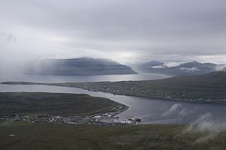
Runavík is a comparatively urbanised village in Runavík Municipality, Faroe Islands. It lies on the south half of the isle of Eysturoy.

<span class="mw-page-title-main">Strandfaraskip Landsins</span> Government agency for public transport in the Faroe Islands

Strandfaraskip Landsins is the government agency for public transport in the Faroe Islands. It is owned by the Faroese national government under the Ministry of Finance (Fíggjamálaráðið) and runs seven ferry routes and a number of bus routes.

Saltangará is a village in the Faroe Islands, on the island of Eysturoy.

<span class="mw-page-title-main">Oyndarfjørður</span> Village in Faroe Islands, Kingdom of Denmark

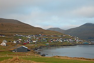
Oyndarfjørður is a village on the northeastern coast of the Faroese island of Eysturoy in the Runavíkar municipality.

<span class="mw-page-title-main">Strendur</span> Village in Faroe Islands, Kingdom of Denmark

Strendur is a village on the Faroese island of Eysturoy, located along the Skálafjørður fjord. It is the seat and main settlement of the Sjóvar Municipality.

<span class="mw-page-title-main">Víkingur Gøta</span> Football club

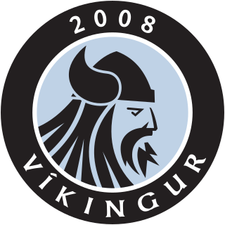
Víkingur is a Faroese professional football club based in Leirvík. The club was founded in 2008 after the merger of GÍ Gøta and Leirvík ÍF. They play at the Serpugerði Stadium in Norðragøta. Both villages are part of the same municipality Eysturkommuna, located on the island of Eysturoy and about 5 kilometers away from each other. The club won the Faroese championship for the first time in the 2016 season. In the 2017 season, Vikingur won the championship again.

The 2008 season of the Faroe Islands Premier League was the 66th season of the Faroese top-tier football since its establishment. It started on 29 March 2008 with a match between B36 Tórshavn and ÍF Fuglafjørður. The match was won by B36 with 4–0. The last games were played on 25 October 2008. NSÍ Runavík were the defending champions.

<span class="mw-page-title-main">Eysturoyartunnilin</span> Undersea road tunnel under the Tangafjørður sound in the Faroe Islands

The Eysturoy Tunnel is a large undersea road tunnel under the Tangafjørður sound in the Faroe Islands, connecting the island of Streymoy to the island of Eysturoy. It also crosses the southern part of Skálafjørður, and connects the towns of Runavík on the eastern side and Strendur on the western side of the fjord, and includes the world's first undersea roundabout in the middle of the network.

A stevna is a regional summer festival in the Faroe Islands, usually accompanied by or built around national rowing boat championships. The races and regattas are always held on Saturdays, except the Ólavsøka race in the capital of Tórshavn, which has a fixed date. There are seven official rowing-related stevnur:

<span class="mw-page-title-main">Sandoyartunnilin</span> Undersea road tunnel in the Faroe Islands

Sandoyartunnilin is an undersea road tunnel in the Faroe Islands. It connects the main island of Streymoy with Sandoy to the south. The length of the tunnel is 10.8 kilometres (6.7 mi), and the estimated cost is 860 million DKK. The tunnel opened for traffic on 21 December 2023, after which the ferry Teistin ceased its route between Gamlarætt on Streymoy and Skopun on Sandoy. The tunnel crosses the Skopunarfjørður and runs from Gamlarætt to Traðardalur in central Sandoy, near the Inni í Dal stadium.

<span class="mw-page-title-main">Streymin Bridge</span> Highway bridge in the Faroe Islands

The Streymin Bridge, is an important highway bridge in the Faroe Islands. It connects the two biggest and most populous islands of Streymoy to the west and Eysturoy to the east. Crossing the Sundini sound at its narrowest point, it is jokingly referred to as the 'Bridge over the Atlantic', being the only inter-island bridge in the Faroe Islands, and one of the few such bridges in the Atlantic Ocean.

<span class="mw-page-title-main">Sundini</span> Sound separating the islands of Streymoy and Eysturoy in the Faroe Islands

Sundini is the northern section of the sound separating the islands of Streymoy and Eysturoy in the Faroe Islands. The southern section of the strait is named Tangafjørður.

Tangafjørður is the southern part of the strait separating the islands of Streymoy and Eysturoy in the Faroe Islands. The northern part of the strait between is named Sundini.

<span class="mw-page-title-main">Fjords in the Faroe Islands</span> List of fjords in the Faroe Islands

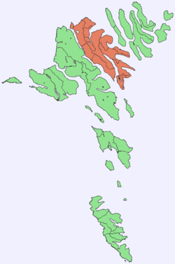
The Faroe Islands consist of 18 islands, several of which are deeply incised by fjords.

References

  1. Statistical Database
  2. "Varmakelda 2019 - Visit Torshavn". visittorshavn.fo.
  3. "portal.fo - Føroysk alifyritøka er áttinda størst í heiminum". Archived from the original on 2015-10-29. Retrieved 2018-11-23.
  4. "Hvalvágir góðkendar".
  5. BirdLife International. (2012). Important Bird Areas factsheet: Eysturoy. Downloaded from "BirdLife International - conserving the world's birds". Archived from the original on 2007-07-10. Retrieved 2012-11-14. on 2012-02-22.

Further reading