
The Faroe Islands is served by an internal transport system based on roads, ferries, and helicopters. As of the 1970s, the majority of the population centres of the Faroe Islands have been joined to a single road network, connected by bridges and tunnels.

Ánir, also Ánirnar is a village in the Faroe Islands on the northern island of Borðoy. In 2007 it had a population of 16, but with the expansion of the area with the new apartments above the old settlement the population has increased to 55 in 2013.

Klaksvík is the second largest town of the Faroe Islands behind Tórshavn. The town is located on Borðoy, which is one of the northernmost islands. It is the administrative centre of Klaksvík municipality.

Hestur is an island in the central Faroe Islands, to the west of Streymoy and the south of Koltur. Hestur means horse in Faroese.

Hvannasund is a village and municipality in the Faroe Islands, an autonomous territory within the Kingdom of Denmark.

Nólsoy is an island and village with a population of 230 people in central Faroe Islands, 4km east of the capital Tórshavn in Streymoy.

Suðuroy is the southernmost of the Faroe Islands. The island covers 163.7 square kilometres (63.2 sq mi). In 2018 the population was 4,601. Suðuroy region (sýsla) comprises this island and Lítla Dímun, the next isle northward in the Faroes, which is uninhabited.

Kalsoy is an island in the north-east of the Faroe Islands of Denmark between Eysturoy and Kunoy. The name means man island; by contrast with the parallel island to the east, Kunoy, the name of which means woman island.

Kunoy is an island located in the north-east of the Faroe Islands between Kalsoy to the west and Borðoy to the east.

Svínoy is an island in the north-east of the Faroe Islands, to the east of Borðoy and Viðoy. It takes its name from Old Norse, Svíney, meaning "Swine Isle". Svinoy also refers to a section of the ocean where North Atlantic water flows into the Norwegian Sea. There is a similarly named island, Swona, in the Orkney Islands.

Fugloy is the easternmost island in the Faroe Islands.
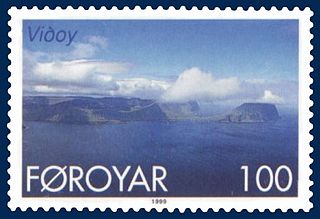
Viðoy is the northernmost island in the Faroe Islands, located east of Borðoy to which it is linked via a causeway. The name means wood island, despite the fact that no trees grow on the island; the name relates to the driftwood that floats in from Siberia and North America.

Skúgvoy is an island in the central Faroe Islands, located to the south of Sandoy.
Sandoy is the first of the five southern islands that make up the Faroe chain, the fifth biggest of all the Faroe Islands, an autonomous region of the Kingdom of Denmark. It also refers to the region that includes this island along with Skúvoy and Stóra Dímun. As of January 2020, the largest population centre on the island is the village of Sandur with a population of 532. Other settlements include Skarvanes, Skopun, Skálavík, Húsavík and Dalur.

Eysturoy is a region and the second-largest of the Faroe Islands, both in size and population.

Viðareiði is the northernmost settlement in the Faroe Islands and lies on the Island of Viðoy, which belongs to the Norðoyar Region.

Norðdepil is a town on the east coast of the island of Borðoy in the Norðoyar Region of the Faroe Islands.

Múli is a hamlet on the island of Borðoy in the Norðoyar Region of the Faroes.

Norðoyatunnilin is a two-lane road tunnel under the Leirvíksfjørður in the Faroe Islands. It connects the islands of Eysturoy and Borðoy. The tunnel is 6.2 km long and goes down to a depth of 150 metres below sea level. The maximum gradient is approximately 6%. The tunnel entrances are near the towns of Leirvík on Eysturoy, and Klaksvík on Borðoy. Until the Eysturoyartunnilin opened in December 2020, Norðoyatunnilin was the longest tunnel in the Faroe Islands.

Klaksvík Municipality is a municipality of the Faroe Islands. The town of Klaksvík is the administrative centre.


