You can help expand this article with text translated from the corresponding article in Russian. Click [show] for important translation instructions.
Machine translation, like DeepL or Google Translate, is a useful starting point for translations, but translators must revise errors as necessary and confirm that the translation is accurate, rather than simply copy-pasting machine-translated text into the English Wikipedia.
Consider adding a topic to this template: there are already 1,247 articles in the main category, and specifying|topic= will aid in categorization.
Do not translate text that appears unreliable or low-quality. If possible, verify the text with references provided in the foreign-language article.
You must provide copyright attribution in the edit summary accompanying your translation by providing an interlanguage link to the source of your translation. A model attribution edit summary is Content in this edit is translated from the existing Russian Wikipedia article at [[:ru:Кольтур]]; see its history for attribution.
You may also add the template {{Translated|ru|Кольтур}} to the talk page.
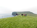
Koltur is an island in the Faroe Islands, located to the west of Streymoy and to the north-west of Hestur. The name 'Koltur' means 'colt', in contrast with the name of the larger island to the south-east, 'Hestur', which means 'horse'.[2] The island has just one settlement, Koltur. It was abandoned in the 1980s by the sheep-farmers whose flocks grazed on the southern part of the island. Since then only two people have returned (in 1994). Koltur has two mountains, Kolturshamar (478 m) and Fjallið (101m) which strictly speaking is not a mountain, the name however translates directly as "The Mountain" and is considered by many as the smallest mountain in the country.
Archaeological excavations have found that barley has been cultivated on the island as far back as 800–900AD, in the early Viking age. It continued to be cultivated up to near modern times, as straw from Koltur was considered the best for thatching, because there are no mice in the island to diminish the quality of the straw.[3] All peat for fuel had to be cut at Syðradal and Fossdal on Streymoy or later in Skopun, Sandoy, and then transported by boat back to Koltur where it was stored in houses at Gróthústanga.
There have been two settlements on the islands, Heima í Húsi and Norðuri í Gerði. There is a story that the two families who lived there couldn't agree about anything and never helped each other with anything, this went on for generations and in the end, it was forgotten what the original argument was about. Though the place-name Trætumørkin[3], hints at the argument being about a parcel of land.
Heima í Húsi is the older settlement and it is thought it is the original settlement on the island. It contains two farms: Niðri í Húsi and Uppi í Búð,[4] The buildings are remarkably well preserved, and although they have had running repairs through the centuries there has been very little modernization compared to the rest of the country, and thus give a great insight into how people have lived in the past.
Norðuri í Gerði is newer than Heima í Húsi, but its old buildings are in much worse condition. Though in the Jarðarbókini from 1584 it is confirmed that this settlement already had been built by then. This is the location of the only inhabited house today.
In 1890 there were 42 people living on the island, spread over 6 families. 1954 was the last time anyone was buried in the cemetery. The cemetery lies some 600 metres to the north-east of the settlement of Norðuri í Gerði; the isolation from the settlement is said to be due to its being haunted, as it could often go long stretches of time before a priest came to the island to throw earth on the grave, and put the dead properly to rest according to custom.
Conservation
In 1987, Føroya Forngripafelag called for a plan to be made to preserve the island's historically important locations. A formal plan for its conservation and continued habitation was put forward in 1990, and on 11 June 1992, it was formally adopted. As a result, some buildings between the two settlements had been repaired by 1996. In 1996, Fornminninevndin proposed to expand the conservation of the settlements, and their proposal was approved in 2000. Between 2000 and 2012, conservation efforts were undertaken in stages, with funding coming from various sources. In 2008 the Mc-Kinney Møllers Fond donated 5 million DKK to the restoration project. The project was deemed complete in 2012, and is now open as a museum.[5] Efforts are ongoing to have the island listed as a national park,[6] as it is the only island[specify] which is run as an organic farm.
Transport
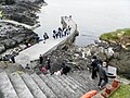
Up until 2024, there was a regular helicopter connection throughout the year, but this was scrapped in June 2024 by Atlantic Airways after the last residents left the island, despite the continued demand for a cost-effect method of reaching Koltur by tourists during the summer season. In summertime, local boat companies offer day trips from Gamlarætt and Tórshavn, but at over-inflated prices which far exceed the costs of visiting by helicopter.
This page is based on this Wikipedia article Text is available under the CC BY-SA 4.0 license; additional terms may apply. Images, videos and audio are available under their respective licenses.