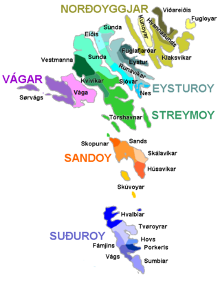
Vágar (Faroese pronunciation:[vɔːaɹ]; Danish: Vågø) is one of the 18 islands in the archipelago of the Faroe Islands and the most westerly of the large islands. With a size of 178 square kilometres (69 square miles), it ranks third in size, behind Streymoy and Eysturoy. Vágar region also comprises the island of Mykines.
The Vágar island shape is very distinctive, since on maps it resembles a dog's head. The fjord Sørvágsfjørður is the mouth and the lake Fjallavatn is the eye.
History
Vágar is the first port of call for most foreigners travelling to the Faroe Islands, as it is home to the islands’ only airport, Vágar Airport. An airfield was built there during World War II by the British, who occupied the Faroe Islands with the islanders' consent. After the war it lay unused for about 20 years, but was then put back into service and expanded/modernised as required. It handles about 290,000 passengers a year (2016). Such large numbers by Faroese standards put a considerable strain on transport facilities, with the result that a road tunnel (Vágatunnilin) measuring 5km (3mi) in length and running under the sea now connects Vágar with the two largest islands in the Faroes and thus the capital Tórshavn.
Tourism
The country's two largest lakes - Sørvágsvatn and Fjallavatn - are to be found there, and the tourist association organises excursions throughout the summer.
Vágar has three large villages: Miðvágur, Sandavágur and Sørvágur and three small ones: Gásadalur, Bøur and Vatnsoyrar. Earlier there were two more villages: Slættanes, which was abandoned in 1965[2] and Víkar,[3] which was abandoned in 1910.[4]
The largest is Miðvágur, which has 1,130 inhabitants[1] (01-2020). It is in the middle of the island and so has naturally become a centre, with a doctor's surgery, co-op and vicarage. It is also a historic village and was home to Beinta Broberg, a clergyman's wife who was dubbed “Wicked Beinta”. The story of her life was told in the famous novel Barbara by Jørgen-Frantz Jacobsen, which was filmed in 1997 by Niels Malmros. The farmhouse Kálvalíð to the north is the oldest house in the village and possibly in the Faroe Islands too. It is now the village museum.
To the east of Miðvágur lies Sandavágur, which has a population of 958 (01-2020). It too is a historic village. It was home to the law speaker of the Faroe Islands until 1816, when the office was abolished and the islands became a Danish administrative district. The clergyman V. U. Hammershaimb, who was born in Sandavágur in 1819 and became the father of the Faroese written language, was the son of the last law speaker. The Sandavágur stone with a runic inscription dating back to around 1200 was found there in 1917 and can now be seen in the Sandavágur church.
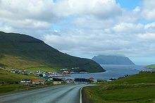
The third large village is Sørvágur, which is on the western side of the island near the airport and has 1,136 inhabitants (01-2020). During World War II, when the airfield was being built in 1942–1944, 5,000 British soldiers lived in Sørvágur, but now few traces remain of their camp to the south of the village. Tindhólmur, Gáshólmur and the two “drangar” (freestanding cliffs) belong to the village. The view out to them is among the most beautiful in the Faroe Islands.
Vágar has two other old villages: Bøur, which lies 4 kilometres (2 miles) west of Sørvágur and has 74 inhabitants (01-2020), and Gásadalur, which lies further west on the Mykinesfjørður strait and has 16 inhabitants (01-2020). Many people have moved away from this village, but it now has a road link in the form of a Gásadalstunnilin through the mountain and it is hoped that the village will start to grow again.
A new village, Vatnsoyrar, which has 44 inhabitants (01-2020), appeared on Vágar in 1921. It was founded by three men, each of whom was given a plot of land to farm and set up home there with his family. The village is in the upland pastures belonging to Miðvágur and so forms part of Miðvágur District. When the British occupied the Faroe Islands and built the airfield on Vágar, Vatnsoyrar was their headquarters. The local population was evacuated, but was able to return home when the war ended.
At the northernmost point of the island, in the upland pastures belonging to Sandavágur, lay the village of Slættanes, which was founded in 1835. It grew for a time and at its largest was home to around 70 people. It also had a school, which can be seen on a stamp. The last residents left in 1964.
Another new village, Víkar, was founded in the upland pastures belonging to Gásadalur on the north side of the island in 1833. The area was good for farming, but the settlement was very isolated, and getting to the next village was a difficult business. The last few inhabitants moved away in 1910.
Vagar has a cold, temperate oceanic climate (Köppen: Cfc), bordering on a tundra climate (ET). It has chilly winters, cool summers and is wet year-round. Snow can fall in trace quantities from November to April.
Bøur is a village in the Sørvágur Municipality of the Faroe Islands, 4 km west of Sørvágur, with a population of 75 (2012).
Gásadalur is a village located on the west side of Vágar, Faroe Islands, and enjoys a panoramic view over to the island of Mykines.
Mykines is the westernmost of the 18 main islands of the Faroese Archipelago.
Streymoy is the largest and most populated island of the Faroe Islands. The capital, Tórshavn, is located on its southeast coast. The name means "island of currents". It also refers to the largest region of the country that also includes the islands of Hestur, Koltur and Nólsoy.
Sørvágur is a village on the island of Vágar in the Faroe Islands.
Sørvágsvatn is the largest lake in the Faroe Islands. It is situated on the island of Vágar between the municipalities of Sørvágur and Vágar. Its area is 3.4 km2 (1.3 sq mi), more than three times the size of Fjallavatn, the second largest lake, also located on Vágar.
Sørvágur Municipality, is the westernmost municipality in the Faroe Islands.
Miðvágur, is a village in the Faroe Islands on Vágar. It has been a municipality until 1 January 2009 when it fused with Sandavágur into Vága kommuna.
Víkar is an abandoned village in the Faroe Islands on the north coast of the island of Vágar.
Slættanes is a village on the island of Vágar in the western Faroes, which is now abandoned and only used as summer homes.
Sandavágur is a town on the south coast of the Faroese island of Vágar. The name Sandavágur means sandy bay and refers to the sandy beach which used to be much larger than present. From one point in Sandavágur you can get a view of all the southern islands in the Faroes. Sandavágur used to be a municipality until 1 January 2009, when it fused together with the neighbour village Miðvágur into the new Vágar municipality.
Strandfaraskip Landsins is the government agency for public transport in the Faroe Islands. It is owned by the Faroese national government under the Ministry of Finance (Fíggjamálaráðið) and runs seven ferry routes and a number of bus routes.
Besides the 18 islands of the Faroes there are also several islets and skerries. The Faroe Islands consist of 18 islands with many small islets and skerries. islets are small and are geographical parts of the larger islands. Suðuroy consists of 263 islands, islets and skerries, which is the largest number. The islets are measured in square hectometers (hectares), the largest being comparable in size to the smallest island, Lítla Dímun.
07 Vestur is a Faroese football club, which was founded in 2007. It is located in Sandavágur and Sørvágur on Vágar island.
Torkil Nielsen is a former Faroese football midfielder. He is also one of the Faroe Islands' best chess players.
The Faroe Islands are administratively divided in 29 municipalities (kommunur), with about 120 cities and villages. Until December 31, 2008, there were 34 municipalities, and until December 31, 2004, there were 48 municipalities. In the coming years the number of Faroese municipalities is expected to drop to somewhere between 7 and 15, as there is currently a rationale towards municipal amalgamation and a decentralization of public services. In 1998 it was suggested that no municipality should have fewer than 2,000 inhabitants, but whether this will be true is a political question. The Faroese government has furthermore decided not to conduct forced, top-down amalgamation, but to leave the process to the free will of the municipalities. In many small municipalities there is some resistance to the amalgamation process, and as a result two kinds of municipalities are being created: large municipalities (town-municipalities) that are eager to attract smaller municipalities into amalgamation, and small municipalities which are either trying to avoid amalgamation or seek to amalgamate with other small municipalities. The geographically large Sunda municipality is an example of this. The larger municipalities are organized in Kommunusamskipan Føroya (KFS) and the smaller are organized in Føroya Kommunufelag (FKF).
SÍF Sandavágur is a Faroese Football club based in Sandavágur on the island of Vágar.
Vágar Municipality is a municipality in the Faroese Islands.
A settlement village is a settlement in the Faroe Islands that was founded during the 1800s or early 1900s. The population of the islands grew quickly from 1800 onward, resulting in a shortage of land in the older villages. Many new villages were established on the periphery of the older ones, and therefore few of the new villages contained state-owned leasehold land.
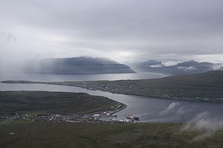
The Faroe Islands consist of 18 islands, several of which are deeply incised by fjords.
This page is based on this Wikipedia article Text is available under the CC BY-SA 4.0 license; additional terms may apply. Images, videos and audio are available under their respective licenses.