Viðoy

Last updated • 1 min readFrom Wikipedia, The Free Encyclopedia
Viðoy
Faroe stamp 349 vidoy.jpg
Stamp FR 349 of Postverk Føroya (issued: 25 May 1999; photo: Per á Hædd)
Position of Vidoy on Faroe map.png
Location within the Faroe Islands
Coordinates: 62°20′N6°31′W / 62.333°N 6.517°W / 62.333; -6.517
State Kingdom of Denmark
Constituent country Faroe Islands
Municipality seat Viðareiði
Area
  Total
41 km2 (16 sq mi)
  Rank7
Highest elevation
841 m (2,759 ft)
Population
 (12-2018)
  Total
605 [1]
  Rank7
Time zone UTC+0 (GMT)
  Summer (DST) UTC+1 (EST)
Calling code298

Viðoy (Faroese pronunciation: [ˈviːjɔɪ] , Danish : Viderø) is the northernmost island in the Faroe Islands, located east of Borðoy to which it is linked via a causeway. The name means wood island, despite the fact that no trees grow on the island; the name relates to the driftwood that floats in from Siberia and North America.

Contents

Geography

The island has two settlements: Hvannasund on the south-west coast and Viðareiði on the north-west coast, the northernmost settlement in the Faroes. A road along the west coast of the island connects the two. The island is connected by a road causeway from Hvannasund to Norðdepil on Borðoy, and a bus service from Klaksvík runs across the causeway to the island. [2]

Important bird area

The island's northern and eastern coast has been identified as an Important Bird Area by BirdLife International because of its significance as a breeding site for seabirds, especially European storm petrels (500 pairs), black-legged kittiwakes (5300 pairs), Atlantic puffins (25,000 pairs), common guillemots (6700 individuals) and black guillemots (200 pairs). [3]

Mountains

RankNameHeight (m)
3Villingadalsfjall841
24 Nakkurin (norðari) 754
29 Malinsfjall 750
52 Filthatturin 688
53 Oyggjarskoratindur 687
67Enni651
84 Sneis 634
116 Tunnafjall 593
147 Talvborð 557
174 Mølin 511
192 Nakkurin 481

Viðoy has eleven mountains, of which Villingadalsfjall is the northernmost peak in the Faroes. The north coast also has the Enniberg cliff, which at 750 m is the second-highest sea-cliff in Europe (after Hornelen, in Norway). The mountains are shown with their overall rank in the Faroe Islands.

See also

List of mountains of the Faroe Islands

Related Research Articles

<span class="mw-page-title-main">Ánirnar</span> Village in Faroe Islands, Kingdom of Denmark

Ánir, also Ánirnar is a village in the Faroe Islands on the northern island of Borðoy. In 2007 it had a population of 16, but with the expansion of the area with the new apartments above the old settlement the population has increased to 55 in 2013.

<span class="mw-page-title-main">Hestur</span> Island in Faroe Islands, Kingdom of Denmark

Hestur is an island in the central Faroe Islands, to the west of Streymoy and the south of Koltur. Hestur means horse in Faroese.

<span class="mw-page-title-main">Hvannasund</span> Municipality and village in Faroe Islands, Kingdom of Denmark

Hvannasund is a village and municipality in the Faroe Islands, an autonomous territory within the Kingdom of Denmark.

<span class="mw-page-title-main">Kirkja</span> Place in Faroe Islands, Kingdom of Denmark

Kirkja is a village on the island of Fugloy, Faroe Islands. It is located on the south-tip of the island, and its land is stretching all over the western side of the island, including a small enclave in the now uninhabited Skarðsvík. Here archaeologists have located an old settlement that has probably been only a part-time settlement used either by people from Kirkja or Hattarvík.

<span class="mw-page-title-main">Nólsoy</span> Island in Faroe Islands, Kingdom of Denmark

Nólsoy is an island and village with a population of 230 people in central Faroe Islands, 4km east of the capital Tórshavn in Streymoy.

<span class="mw-page-title-main">Suðuroy</span> Island in Faroe Islands, Kingdom of Denmark

Suðuroy is the southernmost of the Faroe Islands. The island covers 163.7 square kilometres (63.2 sq mi). In 2018 the population was 4,601. Suðuroy region (sýsla) comprises this island and Lítla Dímun, the next isle northward in the Faroes, which is uninhabited.

<span class="mw-page-title-main">Mykines, Faroe Islands</span> Island in Faroe Islands, Kingdom of Denmark

Mykines is the westernmost of the 18 main islands of the Faroese Archipelago.

<span class="mw-page-title-main">Kalsoy</span> Island in Faroe Islands, Kingdom of Denmark

Kalsoy is an island in the north-east of the Faroe Islands of Denmark between Eysturoy and Kunoy. The name means man island; by contrast with the parallel island to the east, Kunoy, the name of which means woman island.

<span class="mw-page-title-main">Kunoy</span> Island in Faroe Islands, Kingdom of Denmark

Kunoy is an island located in the north-east of the Faroe Islands between Kalsoy to the west and Borðoy to the east.

<span class="mw-page-title-main">Svínoy</span> Island in Faroe Islands, Kingdom of Denmark

Svínoy is an island in the north-east of the Faroe Islands, to the east of Borðoy and Viðoy. It takes its name from Old Norse, Svíney, meaning "Swine Isle". Svinoy also refers to a section of the ocean where North Atlantic water flows into the Norwegian Sea. There is a similarly named island, Swona, in the Orkney Islands.

<span class="mw-page-title-main">Fugloy</span> Island in Faroe Islands, Kingdom of Denmark

Fugloy is the easternmost island in the Faroe Islands.

<span class="mw-page-title-main">Borðoy</span> Island in Faroe Islands, Kingdom of Denmark

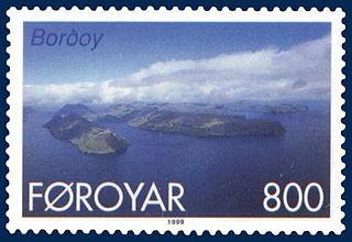
Borðoy is an island in the north-east of the Faroe Islands. Its name means 'headland island'. There are eight settlements: Klaksvík, Norðoyri, Ánir, Árnafjørður, Strond, Norðtoftir, Depil and Norðdepil.

<span class="mw-page-title-main">Koltur</span> Island in Faroe Islands, Kingdom of Denmark

Koltur is an island in the Faroe Islands, located to the west of Streymoy and to the north-west of Hestur. The name 'Koltur' means 'colt', in contrast with the name of the larger island to the south-east, 'Hestur', which means 'horse'. The island has just one settlement, Koltur. It was abandoned in the 1980s by the sheep-farmers whose flocks grazed on the southern part of the island. Since then only two people have returned. Koltur has two mountains, Kolturshamar and Fjallið (101m) which strictly speaking is not a mountain, the name however translates directly as "The Mountain" and is considered by many as the smallest mountain in the country.

<span class="mw-page-title-main">Skúvoy</span> Island in Faroe Islands, Kingdom of Denmark

Skúgvoy is an island in the central Faroe Islands, located to the south of Sandoy.

<span class="mw-page-title-main">Streymoy</span> Island in Faroe Islands, Kingdom of Denmark

Streymoy is the largest and most populated island of the Faroe Islands. The capital, Tórshavn, is located on its southeast coast. The name means "island of currents". It also refers to the largest region of the country that also includes the islands of Hestur, Koltur and Nólsoy.

<span class="mw-page-title-main">Vágar</span> Island in Faroe Islands, Kingdom of Denmark

Vágar is one of the 18 islands in the archipelago of the Faroe Islands and the most westerly of the large islands. With a size of 178 square kilometres, it ranks third in size, behind Streymoy and Eysturoy. Vágar region also comprises the island of Mykines.

<span class="mw-page-title-main">Eysturoy</span> Island in Faroe Islands, Kingdom of Denmark

Eysturoy is a region and the second-largest of the Faroe Islands, both in size and population.

<span class="mw-page-title-main">Viðareiði</span> Municipality and village in Faroe Islands, Kingdom of Denmark

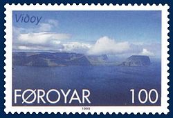
Viðareiði is the northernmost settlement in the Faroe Islands and lies on the Island of Viðoy, which belongs to the Norðoyar Region.

<span class="mw-page-title-main">Norðdepil</span> Village in Faroe Islands, Kingdom of Denmark

Norðdepil is a town on the east coast of the island of Borðoy in the Norðoyar Region of the Faroe Islands.

<span class="mw-page-title-main">Fauna of the Faroe Islands</span> Animals living in the Faroes

The fauna of the Faroe Islands is characterized by the remote location of the islands in the North Atlantic Ocean. There are few terrestrial species, but an abundance of breeding seabirds and marine animals. Some subspecies and breeds are endemic. All land mammals were introduced by humans.

References

  1. Statistical Database
  2. Swaney, Deanna. Iceland, Greenland & the Faroe Islands (3rd ed.). Lonely Planet Publications. ISBN   0-86442-453-1.
  3. BirdLife International. (2012). Important Bird Areas factsheet: Vidoy.