Vestmanna

Last updated
Vestmanna
Municipality and village
Vestmanna, Faroe Islands (7).JPG
Vestmanna in 2002
Map-position-vestmanna-kommuna-2005.png
Location of Vestmanna kommuna in the Faroe Islands
Faroe Islands location map.svg
Red pog.svg
Vestmanna
Location of Vestmanna village in the Faroe Islands
Coordinates: 62°09′23″N7°09′59″W / 62.15639°N 7.16639°W / 62.15639; -7.16639
StateFlag of Denmark (state).svg  Kingdom of Denmark
Constituent countryFlag of the Faroe Islands.svg  Faroe Islands
Island Streymoy
Population
 (January 2024) [1]
  Total1,270
Time zone GMT
  Summer (DST) UTC+1 (WEST)
Postal code
FO 350
Climate Cfc
Website https://vestmanna.fo/

Vestmanna is a town in the Faroe Islands on the west of the island of Streymoy.

Contents

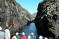
It was formerly a ferry port, until an undersea tunnel, the Vágatunnilin, was built from Vágar to Kvívík and Stykkið further south on Streymoy. The cliffs west of Vestmanna, Vestmannabjørgini, are very popular for excursions by boat.

A 'Vestmann' was a "Westman", or Gael in Old Norse. The original name was Vestmannahavn, i.e. "Westmen's/Irishmen's harbour".

History

In December 1759, during the Seven Years' War, François Thurot's squadron sheltered from stormy conditions at Vestmanna. The lack of supplies available from the islanders motivated the subsequent raids by the squadron on the north Irish coast.

Geography

It is surrounded by the mountains of Hægstafjall (296 m or 971 ft), Økslin (317 m or 1,040 ft), Loysingafjall (639 m or 2,096 ft), and Moskurfjall (624 m or 2,047 ft).

Local power plant Vestmanna, Faroe Islands (9).JPG
Local power plant

Tourism

Vestmanna is often called the tourist village of the Faroe Islands. The main tourist attraction is Vestmannabjørgini. In 2012, a camping site was established at Inni á Fjørð with a capacity of 120 caravans in addition to tents.

Photos from Vestmannabjørgini and Vestmanna

See also

Related Research Articles

<span class="mw-page-title-main">Transport in the Faroe Islands</span> Internal transport system of the Faroe Islands

The Faroe Islands is served by an internal transport system based on roads, ferries, and helicopters. As of the 1970s, the majority of the population centres of the Faroe Islands have been joined to a single road network, connected by bridges and tunnels.

<span class="mw-page-title-main">Tórshavn</span> Capital of the Faroe Islands

Tórshavn, usually locally referred to as simply Havn, is the capital and largest city of the Faroe Islands. It is located in the southern part on the east coast of Streymoy. To the northwest of the city lies the 347-meter-high (1,138 ft) mountain Húsareyn, and to the southwest, the 350-meter-high (1,150 ft) Kirkjubøreyn. They are separated by the Sandá River. The city itself has a population of 14,099 (2024), and the greater urban area has a population of 23,194, including the suburbs of Hoyvík and Argir.

<span class="mw-page-title-main">Regions of the Faroe Islands</span> Administrative subdivisions of the Faroe Islands

The Faroe Islands are divided into 29 municipalities, six regions/shires and since 2007 there has been only one constituency, earlier there were seven constituencies. Each region has one sheriff.

<span class="mw-page-title-main">Hestur</span> Island in Faroe Islands, Kingdom of Denmark

Hestur is an island in the central Faroe Islands, to the west of Streymoy and the south of Koltur. Hestur means horse in Faroese.

<span class="mw-page-title-main">Hvalba</span> Municipality and village in Faroe Islands, Kingdom of Denmark

Hvalba is a village and a municipality in the Faroe Islands, which consists of Hvalba, Nes-Hvalba and Sandvík.

<span class="mw-page-title-main">Suðuroy</span> Island in Faroe Islands, Kingdom of Denmark

Suðuroy is the southernmost of the Faroe Islands. The island covers 163.7 square kilometres (63.2 sq mi). In 2018 the population was 4,601. Suðuroy region (sýsla) comprises this island and Lítla Dímun, the next isle northward in the Faroes, which is uninhabited.

<span class="mw-page-title-main">Streymoy</span> Island in Faroe Islands, Kingdom of Denmark

Streymoy is the largest and most populated island of the Faroe Islands. The capital, Tórshavn, is located on its southeast coast. The name means "island of currents". It also refers to the largest region of the country that also includes the islands of Hestur, Koltur and Nólsoy.

<span class="mw-page-title-main">Eysturoy</span> Island in Faroe Islands, Kingdom of Denmark

Eysturoy is a region and the second-largest of the Faroe Islands, both in size and population.

<span class="mw-page-title-main">Sandvík</span> Village in Faroe Islands, Kingdom of Denmark

Sandvík is the northernmost village of the island of Suðuroy in the Faroe Islands. It is situated on the northern side of a shallow fjord. The village was previously known as Hvalvík. It changed its name to Sandvík in 1913 as there was too much confusion regarding mail delivery, because there is another village named Hvalvík on Streymoy. The village had originally been known as Sandvík during the Viking Age.

<span class="mw-page-title-main">Sumba, Faroe Islands</span> Municipality and village in Faroe Islands, Kingdom of Denmark

Sumba is the southernmost village of the Faroe Islands, located on the island of Suðuroy. It is located in Sumbiar Municipality.

<span class="mw-page-title-main">Vágur</span> Municipality and village in Faroe Islands, Kingdom of Denmark

Vágur, meaning bay, is a town and municipality on the island of Suðuroy, part of the Faroe Islands.

<span class="mw-page-title-main">Kvívík</span> Municipality and village in Faroe Islands, Kingdom of Denmark

Kvívík is a village and municipality on the west coast of Streymoy in the Faroe Islands.

<span class="mw-page-title-main">Velbastaður</span> Village in Faroe Islands, Kingdom of Denmark

Velbastaður is a village on the island of Streymoy in the Faroe Islands. It is a part of Tórshavn Municipality and is considered among the oldest settlements in the islands. There are two schools and one kindergarten in the village, with children coming from the neighboring village of Kirkjubø as well the capital at Tórshavn.

<span class="mw-page-title-main">Strandfaraskip Landsins</span> Government agency for public transport in the Faroe Islands

Strandfaraskip Landsins is the government agency for public transport in the Faroe Islands. It is owned by the Faroese national government under the Ministry of Finance (Fíggjamálaráðið) and runs seven ferry routes and a number of bus routes.

<span class="mw-page-title-main">Norðradalur</span> Village in Faroe Islands, Kingdom of Denmark

Norðradalur is a village on the western coast of the Faroese island of Streymoy in Tórshavn Municipality. The 2015 population was 15. Its postal code is FO 178. The village lies in a large valley surrounded be steep cliffs and the ocean, with views over Koltur.

<span class="mw-page-title-main">Oyri</span> Village in Faroe Islands, Kingdom of Denmark

Oyri is a village on the central west coast of the Faroese island Eysturoy in the Sunda municipality.

Signabøur is a village on the east coast of the Faroese island Streymoy in Tórshavn Municipality.

<span class="mw-page-title-main">SEV (company)</span> Power producer and distributor on the Faroe Islands

SEV is a power producer and distributor on the Faroe Islands. The company name is derived from the names of islands Streymoy, Eysturoy and Vágar, which established the company on 1 October 1946. All municipalities in Vágar, all in Eysturoy except for Sjóvar municipality and all municipalities in Streymoy except for Tórshavn, Kvívík and Kollafjørður met at the first establishing meeting. Later all municipalities in the Faroe Islands joined SEV. In 2015 60% of the produced electricity of SEV came from green energy sources, 17,8% came from the windmills in Neshagi and Húsahagi, 42,3% came was hydropower.

<span class="mw-page-title-main">Skopunarfjørður</span> Strait separating Sandoy and Streymoy in the Faroe Islands

Skopunarfjørður is a strait separating Sandoy and Streymoy in the Faroe Islands. The strait also passes the isle of Hestur.

References