
Red Hill is a census-designated place (CDP) in Horry County, South Carolina, United States. The population was 13,223 at the 2010 census, up from 10,509 at the 2000 census.

The Buena Vista Ferry connects Marion County and Polk County across the Willamette River in the U.S. state of Oregon. It is located a few miles south of Independence, near the community of Buena Vista. The river is approximately 720 feet wide at the crossing. The cable ferry has a capacity of six vehicles.
Northgate is a neighborhood in Salem, Oregon, United States, located in the far north part of the city. It is one of Salem's larger districts and much of it is industrial rather than residential. Northgate has a neighborhood association, one of the nineteen such groups in Salem.

Wren is an unincorporated community in Benton County, Oregon, United States. It is located at the junction of U.S. Route 20 and Oregon Route 223 on the Marys River.

Waldo Park is a municipal park, located in downtown Salem, Oregon, United States. It is one of the smallest city parks in the world, measuring 12 by 20 feet. The park consists of a giant sequoia surrounded by landscaping and marked with a plaque and sign.
South Central is a neighborhood in Salem, Oregon, United States, located just south of downtown. Major neighborhood features include Bush's Pasture Park, the Asahel Bush House and Museum, Deepwood Estate, Gaiety Hill-Bush's Pasture Park Historic District, South Salem High School, and Mahonia Hall, the official residence of the Governor of Oregon.

John Minto IV was an American pioneer born in Wylam, England. He was a prominent sheep farmer in the U.S. state of Oregon and a four-time Republican representative in the state legislature. Minto also volunteered for the militia during the Cayuse War and years later helped locate Minto and Santiam passes through the Cascade Mountains east of Salem, Oregon.

Eaton Hall is an academic building on the campus of Willamette University in Salem, Oregon, United States. Completed in 1909, the four-story brick and stone hall is the fourth oldest building on the campus of the school after Waller Hall (1867), Gatke Hall (1903), and the Art Building (1907). Eaton is a mix of architectural styles and houses the humanities departments of the liberal arts college.

Pedee is an unincorporated community in Polk County, Oregon, United States. Pedee is at the intersection of Oregon Route 223 and Maple Grove Road. It is part of the Salem Metropolitan Statistical Area.

Rickreall Creek is a stream in Polk County, Oregon, United States rising on Laurel Mountain in the Central Oregon Coast Range and draining into the Willamette River west of Salem at Eola. The creek passes through the city of Dallas and the unincorporated community of Rickreall. The origin of the name is under some dispute, but one theory says that "Rickreall" is a corruption of "La Creole", La Creole River being another name for the stream.
Salt Creek is an unincorporated historic community in Polk County, Oregon, United States on Oregon Route 22 about six miles northwest of Dallas. As an early European American settlement of the Oregon Country, the cemetery at Salt Creek has graves dating back to 1847. Salt Creek, a tributary of the South Yamhill River, was named by early settlers for the salt licks found on its banks. The Salt Creek post office, named after the creek, was established in 1852 and closed in 1903. James B. Riggs, who arrived in Oregon via the Oregon Trail and the Meek Cutoff in 1845, was the first postmaster. Riggs previously been the first postmaster of Yoncalla, followed by Jesse Applegate.
Airlie is an unincorporated community in Polk County, Oregon, United States.
Rosedale is an unincorporated community in Marion County, Oregon. It is located just south of Salem in the Salem Hills. It is a part of the Salem Metropolitan Statistical Area. Rosedale post office ran from 1892 to 1901. The Rosedale area was a major prune growing region in the early 20th century but is now primarily made up of rural residential properties Vineyards and Christmas tree fields. Rosedale Elementary School located at 6974 Bates Road Salem, Oregon was in service from 1893 until its closing in 2012.
Derry is an unincorporated locale in Polk County, Oregon, United States. It is located about 10 miles west of Salem and one mile east of Rickreall.
Faye Wright is a neighborhood in Salem, Oregon, United States, located in the southeast part of the city.The neighborhood is bordered on the east by Commercial Street SE, on the west by Liberty Road S, and on the south by Kuebler Boulevard SE.
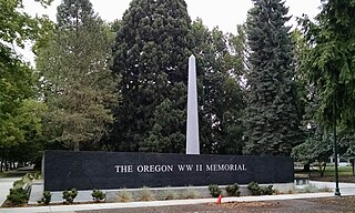
The Oregon World War II Memorial is a war memorial on the grounds of the Oregon State Capitol, in the Salem, Oregon, United States. It was dedicated on June 6, 2014.

The World War I Memorial, also known as the Veterans Memorial, is a relief sculpture and war memorial by artist Frederic Littman and architect Pietro Belluschi, installed of the exterior of Salem, Oregon's Marion County Courthouse, in the United States. The marble sculpture was dedicated in 1954 and depicts a grieving woman kneeling and holding a wreath. Viesko & Post served as the contractor of the project. The sculpture was deemed "well maintained" during the Smithsonian Institution's "Save Outdoor Sculpture!" program in July 1993.

The Veterans of Foreign Wars Monument, also known as To All Who Have Served, is a monument installed outside the Oregon Department of Veterans' Affairs building in Salem, Oregon, United States. The memorial features a soldier atop a globe.

The Truman Wesley Collins Legal Center houses the Willamette University College of Law at Willamette University in Salem, Oregon, United States. Located on Winter Street, just south of the Oregon State Capitol, the facility features classrooms, the law library, administrative offices, and faculty offices. The building also contains a fully functioning trial courtroom used for moot court. It houses Lady Justice, the 12-foot (3.7 m)-tall, 300-pound (140 kg) statue formerly located on the roof of the Marion County Courthouse.

To Scale the Scales of Justice is a 2010 marble sculpture by M.J. Anderson, installed outside the Justice Building in Salem, Oregon, United States.


