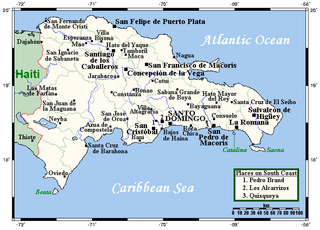
The Dominican Republic is a country in the West Indies that occupies the eastern five-eighths of Hispaniola. It has an area of 48,670 km², including offshore islands. The land border shared with Haiti, which occupies the western three-eighths of the island, is 376 km long. The maximum length, east to west, is 390 km from Punta de Agua to Las Lajas, on the border with Haiti. The maximum width, north to south, is 265 km from Cape Isabela to Cape Beata. The capital, Santo Domingo, is located on the south coast.
The term Samaná or Samana can mean one of several things:

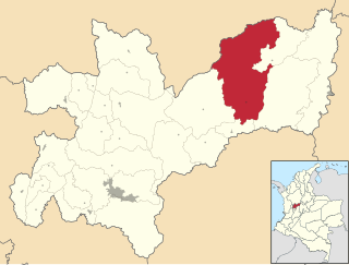
San Carlos is a town and municipality in the Colombian department of Antioquia, part of the subregion of Eastern Antioquia. Is called, the hydro-electrical capital of Colombia, because it has many dams and it produces lots of energy.

Weston, Washington, began life c. 1885-6. Located at the foot of the western 2.2 percent grade of the Northern Pacific Railway's climb up Stampede Pass to Stampede Tunnel, the town served as the western helper station on the pass, counterpart to Easton, Washington. Facilities included an engine house, telegraph station, water tank, turntable and some ancillary residences and eating houses.
Olustee is an unincorporated community in Baker County, Florida, United States. The name "Olustee" is from the nearby Olustee Creek whose name derives from the Creek (Muscogee) language ue-lvste (/oy-lást-i/) meaning "black water". The town was historically known as Olustee Station and is the location of the Olustee Battlefield Historic State Park and of the ranger station for the Osceola National Forest, which is headquartered there. The US Forest Service has restored the former railroad depot at the center of town as a visitor center and museum for forest visitors.
Samaná Bay is a bay in the eastern Dominican Republic. The Yuna River flows into Samaná Bay, and it is located south of the town and peninsula of Samaná.
Samaná is a town and municipality in the Colombian Department of Caldas.

Egypt is an unincorporated community in Jordan Township, Jasper County, Indiana.

Oliver is a former settlement in Yuba County, California, United States. It was on the Western Pacific Railroad 1 mile (1.6 km) south of Marysville, at an elevation of 52 feet. It still appeared on maps in 1952.

Hillen is a small community just west of Hillen Road and Morgan State University and south of Coldspring Lane in Baltimore, Maryland, United States.
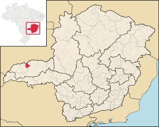
Canápolis is a Brazilian municipality located in the west of the state of Minas Gerais. Its population as of 2007 was 11,313 living in a total area of 845 km². The city belongs to the statistical mesoregion of Triângulo Mineiro and Alto Paranaíba and to the statistical microregion of Uberlândia. It became a municipality in 1948.
Camp Hill is a cinder cone in northern British Columbia, Canada. It is thought to have last erupted in the Holocene period.

Sánchez, Dominican Republic is a Dominican municipality in the Samaná province, on the south coast of the peninsula of Samaná.

Dobrzykowo is a village in the administrative district of Gmina Barciany, within Kętrzyn County, Warmian-Masurian Voivodeship, in northern Poland, close to the border with the Kaliningrad Oblast of Russia. It lies approximately 14 kilometres (9 mi) north-west of Barciany, 28 km (17 mi) north-west of Kętrzyn, and 74 km (46 mi) north-east of the regional capital Olsztyn.

Toadtown is an unincorporated community in Butte County, California. It lies at an elevation of 2782 feet.
The Hebridean Light Railway Company proposed to operate on the Scottish islands of Skye and Lewis. The Skye line was to have connected the port of Isleornsay and the port of Uig on the north-west coast of the island, from where ferries would have sailed to Stornoway on Lewis. Another line was then proposed to link Stornoway to Carloway, the second settlement of Lewis. Branch lines were also proposed to Breasclete and Dunvegan.
La Miel is a river in Colombia and a tributary of the Magdalena River. The river originates in the Cordillera Central of the Andes and its watershed is located within the Caldas Department. Tributaries of La Miel include the Tenerife, Salado, Manso, Moro, Pensilvania, Samana and Dulce rivers. The Miel I Dam is situated on the river.
The Guatapé is a river in Antioquia Department, Colombia and a tributary of the Samaná Norte River. The Jaguas, Las Playas and San Carlos hydroelectric power plants are located on its stem.
Camp Creek is a stream in Montgomery, Warren and Lincoln counties in Missouri. It is a tributary of the West Fork of the Cuivre River.


