Related Research Articles

Meghalaya is a state in northeast India. Meghalaya was formed on 21 January 1972 by carving out two districts from the state of Assam: (a) the United Khasi Hills and Jaintia Hills and (b) the Garo Hills. The population of Meghalaya as of 2014 is estimated to be 3,211,474. Meghalaya covers an area of approximately 22,430 square kilometres, with a length-to-breadth ratio of about 3:1.
East Garo Hills is an administrative district in the state of Meghalaya in India.

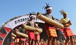
Baghmara is the headquarters of South Garo Hills district in the state of Meghalaya in India. The place is bordered by Bangladesh and is about 113 km from Tura; 248 km from Guwahati; and 287 km from state capital Shillong. It has the famous river, Someshwari, also known as Simsang in Garo tribal language, flowing through its expanse and is also covered in hills and tracts along the way. This southern part of the Garo Hills region has lots of tourist spots compared to other districts and is a popular tourist destination for both domestic and international tourists when it comes to tourism in Western Meghalaya.
Williamnagar, formerly known as Simsanggre, is the headquarters of East Garo Hills district in the state of Meghalaya in India.

The Garo people, are a Tibeto-Burmese ethnic group inhabiting predominantly in Northeast Indian states of Meghalaya, Assam, Tripura and Nagaland, and in some neighbouring areas of Bangladesh, including Madhupur, Mymensingh, Haluaghat, Dhobaura, Durgapur, Kolmakanda, Jamalpur, Sherpur, Jhinaigati, Nalitabari, Gazini Hills Madhyanagar, Bakshiganj and Sribardi. Historically, the name Garo was used for wide range of inhabitant in southern bank of Brahmaputra but now refers to those who call themselves A•chik Mande or simply A•chik or Mande and the name "Garo" is now being used by outsiders as an exonym.They are the second-largest tribe in Meghalaya after the Khasi and comprise about a third of the local population.
The Garo Hills are part of the Garo-Khasi range in Meghalaya, India. They are inhabited by the Garo people. It is one of the wettest places in the world. The range is part of the Meghalaya subtropical forests ecoregion.
Bermo is a community development block that forms an administrative division in the Bermo subdivision of the Bokaro district, Jharkhand state, India.
Nawadih is a community development block that forms an administrative division in the Bermo subdivision of the Bokaro district, Jharkhand state,
Deori is a community development block that forms an administrative division in the Khori Mahuwa subdivision of the Giridih district in the Indian state of Jharkhand.
Dumri is a community development block that forms an administrative division in the Dumri sub-division of the Giridih district in the Indian state of Jharkhand.
Giridih is a community development block that forms an administrative division in the Giridih Sadar subdivision of the Giridih district in the Indian state of Jharkhand.
Tisri is a community development block that forms an administrative division in the Khori Mahuwa subdivision of the Giridih district in the Indian state of Jharkhand.
Resubelpara, also known as Resu, is the headquarters of North Garo Hills District in the state of Meghalaya in India. The town is situated along the Damring River.
Bansamgre is a village in Samanda block, East Garo Hills district of Meghalaya state of India.
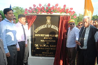
Southwest Garo Hills is an administrative district in the State of Meghalaya, India. The Ampati Civil Sub-Division is upgraded to a full fledged district asSouth West Garo Hills, on 7 August 2012 with its headquarters at Ampati. It was inaugurated by Dr. Mukul Sangma, Hon'ble Chief Minister of Meghalaya, India.
Chandrapura is a community development block that forms an administrative division in the Bermo subdivision of the Bokaro district, Jharkhand state, India.
Tundi is a community development block that forms an administrative division in Dhanbad Sadar subdivision of Dhanbad district, Jharkhand state, India.
Baghmara is a community development block that forms an administrative division in Dhanbad Sadar subdivision of Dhanbad district, Jharkhand state, India.
Dhanbad is a community development block that forms an administrative division in Dhanbad Sadar subdivision of Dhanbad district, Jharkhand state, India.
Baliapur is a community development block that forms an administrative division in Dhanbad Sadar subdivision of Dhanbad district, Jharkhand state, India.
References
- ↑ East Garo Hills Village and Town Directory, District Census Handbook, 2011 Census of India, p. 27
- ↑ East Garo District handbook, p. 415–420