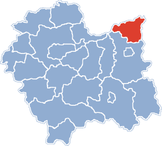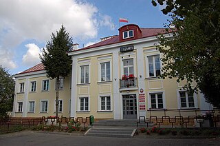
Dąbrowa Tarnowska is a town in Poland, in Lesser Poland Voivodeship, about 16 kilometres (10 mi) north of Tarnów. It is the capital of Dąbrowa County. Before reorganization Dąbrowa Tarnowska was part of Tarnów Voivodeship (1975–1998). Population is 11,402 (2008). Dąbrowa Tarnowska has a rail station on the minor line which joins Tarnów and Szczucin.

Zalipie is a village in Poland, in Gmina Olesno, Dąbrowa County, Lesser Poland Voivodeship. It is approximately 7 kilometres (4 mi) west of Olesno, 13 km (8 mi) north-west of Dąbrowa Tarnowska, and 68 km (42 mi) east of the regional capital Kraków.

Wałdowo Królewskie is a village in the administrative district of Gmina Dąbrowa Chełmińska, within Bydgoszcz County, Kuyavian-Pomeranian Voivodeship, in north-central Poland. It lies 3 kilometres (2 mi) south-west of Dąbrowa Chełmińska, 19 km (12 mi) east of Bydgoszcz, and 28 km (17 mi) north-west of Toruń.
Parlinek is a village in the administrative district of Gmina Dąbrowa, within Mogilno County, Kuyavian-Pomeranian Voivodeship, in north-central Poland. It lies approximately 9 kilometres (6 mi) north-west of Mogilno and 46 km (29 mi) south of Bydgoszcz.
Dąbrowa-Dzięciel is a village in the administrative district of Gmina Wysokie Mazowieckie, within Wysokie Mazowieckie County, Podlaskie Voivodeship, in north-eastern Poland. It lies approximately 7 kilometres (4 mi) south-west of Wysokie Mazowieckie and 56 km (35 mi) south-west of the regional capital Białystok.
Morzychna is a village in the administrative district of Gmina Dąbrowa Tarnowska, within Dąbrowa County, Lesser Poland Voivodeship, in southern Poland. It lies approximately 3 kilometres (2 mi) west of Dąbrowa Tarnowska and 74 km (46 mi) east of the regional capital Kraków.
Bieniaszowice is a village in the administrative district of Gmina Gręboszów, within Dąbrowa County, Lesser Poland Voivodeship, in southern Poland. It lies approximately 17 kilometres (11 mi) west of Dąbrowa Tarnowska and 62 km (39 mi) east of the regional capital Kraków.
Hubenice is a village in the administrative district of Gmina Gręboszów, within Dąbrowa County, Lesser Poland Voivodeship, in southern Poland. It lies approximately 16 kilometres (10 mi) north-west of Dąbrowa Tarnowska and 68 km (42 mi) east of the regional capital Kraków.
Kozłów is a village in the administrative district of Gmina Gręboszów, within Dąbrowa County, Lesser Poland Voivodeship, in southern Poland. It lies approximately 4 kilometres (2 mi) north-east of Gręboszów, 17 km (11 mi) north-west of Dąbrowa Tarnowska, and 67 km (42 mi) east of the regional capital Kraków.
Okręg is a village in the administrative district of Gmina Gręboszów, within Dąbrowa County, Lesser Poland Voivodeship, in southern Poland. It lies approximately 18 kilometres (11 mi) west of Dąbrowa Tarnowska and 61 km (38 mi) east of the regional capital Kraków.
Adamierz is a village in the administrative district of Gmina Olesno, within Dąbrowa County, Lesser Poland Voivodeship, in southern Poland. It lies approximately 3 kilometres (2 mi) south-west of Olesno, 8 km (5 mi) north-west of Dąbrowa Tarnowska, and 71 km (44 mi) east of the regional capital Kraków.
Ćwików is a village in the administrative district of Gmina Olesno, within Dąbrowa County, Lesser Poland Voivodeship, in southern Poland. It lies approximately 4 kilometres (2 mi) north-west of Olesno, 10 km (6 mi) north-west of Dąbrowa Tarnowska, and 72 km (45 mi) east of the regional capital Kraków.
Dąbrowica is a village in the administrative district of Gmina Szczucin, within Dąbrowa County, Lesser Poland Voivodeship, in southern Poland. It lies approximately 5 kilometres (3 mi) north-east of Szczucin, 20 km (12 mi) north-east of Dąbrowa Tarnowska, and 89 km (55 mi) east of the regional capital Kraków.
Łęka Szczucińska is a village in the administrative district of Gmina Szczucin, within Dąbrowa County, Lesser Poland Voivodeship, in southern Poland. It lies approximately 7 kilometres (4 mi) north-east of Szczucin, 22 km (14 mi) north-east of Dąbrowa Tarnowska, and 91 km (57 mi) east of the regional capital Kraków.
Maniów is a village in the administrative district of Gmina Szczucin, within Dąbrowa County, Lesser Poland Voivodeship, in southern Poland. It lies approximately 7 kilometres (4 mi) north-east of Szczucin, 22 km (14 mi) north-east of Dąbrowa Tarnowska, and 91 km (57 mi) east of the regional capital Kraków.
Zabytów is a village in the administrative district of Gmina Skierbieszów, within Zamość County, Lublin Voivodeship, in eastern Poland. It lies approximately 8 kilometres (5 mi) north-west of Skierbieszów, 19 km (12 mi) north of Zamość, and 64 km (40 mi) south-east of the regional capital Lublin.
Dąbrowa Mała is a village in the administrative district of Gmina Ślesin, within Konin County, Greater Poland Voivodeship, in west-central Poland. It lies approximately 3 kilometres (2 mi) south-west of Ślesin, 15 km (9 mi) north of Konin, and 92 km (57 mi) east of the regional capital Poznań.
Cielętniki is a village in the administrative district of Gmina Dąbrowa Zielona, within Częstochowa County, Silesian Voivodeship, in southern Poland. It lies approximately 4 kilometres (2 mi) north of Dąbrowa Zielona, 33 km (21 mi) east of Częstochowa, and 81 km (50 mi) north-east of the regional capital Katowice.
Dąbrowa Łużycka is a village in the administrative district of Gmina Przewóz, within Żary County, Lubusz Voivodeship, in western Poland, close to the German border. It lies approximately 22 kilometres (14 mi) south-west of Żary and 64 km (40 mi) south-west of Zielona Góra.
Dąbrowa Białogardzka is a village in the administrative district of Gmina Rąbino, within Świdwin County, West Pomeranian Voivodeship, in north-western Poland. It lies approximately 9 kilometres (6 mi) south-west of Rąbino, 8 km (5 mi) east of Świdwin, and 96 km (60 mi) north-east of the regional capital Szczecin.