
Oaxaca, officially the Free and Sovereign State of Oaxaca, is one of the 32 states that compose the Federative Entities of Mexico. It is divided into 570 municipalities, of which 418 are governed by the system of usos y costumbres with recognized local forms of self-governance. Its capital city is Oaxaca de Juárez.
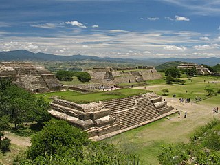
Oaxaca de Juárez, or simply Oaxaca, is the capital and largest city of the eponymous Mexican state of Oaxaca. It is the municipal seat for the surrounding municipality of Oaxaca. It is in the Centro District in the Central Valleys region of the state, in the foothills of the Sierra Madre at the base of the Cerro del Fortín, extending to the banks of the Atoyac River. Heritage tourism makes up an important part of the city's economy, and it has numerous colonial-era structures as well as significant archeological sites and elements of the continuing native Zapotec and Mixtec cultures. The city, together with the nearby archeological site of Monte Albán, was designated in 1987 as a UNESCO World Heritage Site. It is the site of the month-long cultural festival called the "Guelaguetza", which features Oaxacan dance from the seven regions, music, and a beauty pageant for indigenous women.

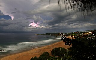
Puerto Escondido is a small port and tourist center in the municipality of San Pedro Mixtepec Distrito 22 in the Mexican state of Oaxaca. Prior to the 1930s, there was no town. The bay had been used as a port intermittently to ship coffee, but there was no permanent settlement due to the lack of potable water. The name "Puerto Escondido" had roots in the legend of a woman who escaped her captors and hid here. The Nahuatl word for this area was Zicatela, meaning “place of large thorns". Today, it refers to the area's most famous beach.

Juchitán de Zaragoza is an indigenous town in the southeast of the Mexican state of Oaxaca. It is part of the Juchitán District in the west of the Istmo de Tehuantepec region. With a 2005 census population of 74,714 inhabitants, it is the fourth-largest city in the state. The majority of the indigenous inhabitants are Zapotecs and Huaves. The town also serves as the municipal seat for the surrounding municipality, with which it shares a name. The municipality has an area of 414.64 km2 and a population of 85,869, the state's third-largest in population.
Huatulco, formally Bahías de Huatulco, centered on the town of La Crucecita, is a tourist development in Mexico. It is located on the Pacific coast in the state of Oaxaca. Huatulco's tourism industry is centered on its nine bays, thus the name Bahias de Huatulco, but has since been unofficially shortened to simply Huatulco. Huatulco has a wide variety of accommodation from rooms for rent, small economy hotels, luxury villas, vacation condominia, bed and breakfasts, as well as several luxury resorts standing on or near the shores of Tangolunda Bay. The Camino Real Zaashila, Quinta Real Huatulco, Las Brisas, Dreams Resort & Spa, and the Barceló are examples of the most popular larger resorts in the area.
San Mateo Río Hondo is the name of a town and municipality in the state of Oaxaca, Mexico. It is part of the Miahuatlán District in the south of the Sierra Sur Region.It is 2,300 meters above sea level. Known in the colonial era as "Tetequipa" in Nahuatl and "Yegoyoxi" in Zapotec, both names meaning "river of sand." As municipal seat San Mateo Río Hondo has governing jurisdiction over the following communities: Barranca Grande, El Campanario, El Cuachepil, El Encino, El Esfuerzo, El Manzanal, El Naranjal, El Progreso, El Tavel, Falda de Portillo, Horno de Cal, Jalatengo, La Concepción, La Doncella, La Floreña, La Victoria, Las Nubes, Las Tinas, Loma San Marcial, Miramar, Piedra Gentil, Pinabete, Ranchería Yogoló, Rancho Cañas, Rancho Cerezales, Rancho Madroño, Rancho Nuevo, Río Cuapinol, Río Grande, Río Molino, Río Pacífico, San Antonio, San Felipe (Manzanillo), San Ildefonso Ozolotepec, San José del Pacífico, San Melchor, San Pablo, Tres Cruces, Yogoló, and Zapotitlán. San Mateo Rio Hondo is divided into three areas: Nochixtlán district, Mixtecan region and San Mateo Sindihui. The municipality has three hills: La Postura, Zaniltepec and Cerro León. The weather is mostly cold and wet. The population is 3,495. The surface area is 81.96 km².
Totontepec Villa de Morelos is a small village and municipality, in the Sierra Mixe district of the Mexican state of Oaxaca. It is located some 1840 metres above sea level and some 326 km from the state capital, Oaxaca de Juárez. In spite of the Mixe influence, the toponym is Nahuatl in origin, meaning "hot hill".

San Pedro Pochutla is a city and municipality located in the south of Oaxaca state, Mexico next to the Pacific Ocean. It is an important commercial, transportation and administrative hub for the Pochutla District in the east of the Costa Region. Pochutla is located at the junction of coastal Highway 200 and Highway 175 to Oaxaca, with 175 functioning as the town's main thoroughfare. Its name means "place of kapok trees ", and most of the city is built on a lakebed which was drained during the colonial period. The municipality is best known as being the home of the oceanside communities of Puerto Ángel and Zipolite.
San Agustinillo is a small fishing village and beach in the state of Oaxaca, Mexico. It is located in the municipality of Santa María Tonameca just east of the coastal communities of Mazunte and La Ventanilla. This is where the Sierra Madre del Sur mountains meet the Pacific Ocean.

Santa María del Tule is a town and a municipality in the Mexican state of Oaxaca. It is part of the Centro District in the Valles Centrales region. It is located 11 kilometers (6.8 mi) SE of the city of Oaxaca on Highway 190. The town and municipality are named for the patron saint of the place, the Virgin Mary and “Tule” comes from the Náhuatl word “tulle” or “tullin” which means bulrush.

San Juan Bautista Tuxtepec, or simply referred to as Tuxtepec, is the head of the municipality by the same name and is the second most populous city of the Mexican state of Oaxaca. It is part of the Tuxtepec District of the Papaloapan Region. As of the 2020 census, the city is home to a population of 103,609 and 159,452 in the municipality, though census data are often under reported for various reasons. The municipality resides in the region called La Cuenca, is located 36 feet above sea level, and occupies an area of approximately 580 square miles (1,500 km2). The city itself is surrounded by the Papaloapan River, and lies a few kilometers south of the Cerro de Oro Dam on its tributary the Santo Domingo River. The municipality is bordered by the state of Veracruz in the north, the municipalities of Loma Bonita to the east and San José Chiltepec to the south. It is almost 100 miles (160 km) to the port of Veracruz, 130 miles (210 km) to Oaxaca City, the state capital, and 310 miles (500 km) to Mexico City.

Santa Lucía del Camino is a city and its surrounding municipality located in the central part of the Mexican state of Oaxaca. It lies just 3 km east of the state capital city of Oaxaca, within the Oaxaca metropolitan area. It is part of the Centro District in the Valles Centrales region.
Eloxochitlán de Flores Magón, formerly known as San Antonio Eloxochitlán, is a city and municipality in the Mexican state of Oaxaca. It is part of the Teotitlán District in the north of the Cañada Region. Approximately 96% of the inhabitants of the municipality speak the indigenous Tecóatl Mazatec.

Tlaxiaco is a city, and its surrounding municipality of the same name, in the Mexican state of Oaxaca. It is located in the Tlaxiaco District in the south of the Mixteca Region, with a population of about 17,450.
Santa Catarina Juquila is a town in the State of Oaxaca, Mexico, and is the seat of the municipality also called Santa Catarina Juquila. It is part of the Juquila District in the center of the Costa Region. The name "Juquila" comes from "Xuhquililla", which means "Place of blue milkweed".

Ixtlán de Juárez is a town and municipality in the Mexican state of Oaxaca about 65 km north of the city of Oaxaca on Federal Highway 175 towards Veracruz. It is part of the Ixtlán District in the Sierra Norte de Oaxaca region.
San Bartolo Coyotepec is a town and municipality located in the center of the Mexican state of Oaxaca. It is in the Centro District of the Valles Centrales region about fifteen km south of the capital of Oaxaca.

San Pablo Huitzo is a town and municipality in Oaxaca in south-western Mexico. The municipality covers an area of 63.80 km². It is part of the Etla District in the Valles Centrales region. As of 2005, the municipality had a total population of 5,242.
Teotitlán del Valle is a small village and municipality located in the Tlacolula District in the east of the Valles Centrales Region, 31 km from the city of Oaxaca in the foothills of the Sierra Juárez mountains. It is part of the Tlacolula Valley district. It is known for its textiles, especially rugs, which are woven on hand-operated looms, from wool obtained from local sheep and dyed mainly with local, natural dyes. They combine historical Zapotec designs with contemporary designs such as reproductions of famous artists' work. Artists take commissions and participate in tours of family-owned workshops. The name Teotitlán comes from Nahuatl and means "land of the gods." Its Zapotec name is Xaguixe, which means "at the foot of the mountain." Established in 1465, it was one of the first villages founded by Zapotec peoples in this area and retains its Zapotec culture and language.

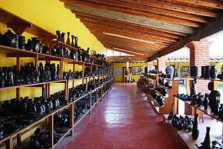
Oaxaca handcrafts and folk art is one of Mexico's important regional traditions of its kind, distinguished by both its overall quality and variety. Producing goods for trade has been an important economic activity in the state, especially in the Central Valleys region since the pre-Hispanic era which the area laid on the trade route between central Mexico and Central America. In the colonial period, the Spanish introduced new raw materials, new techniques and products but the rise of industrially produced products lowered the demand for most handcrafts by the early 20th century. The introduction of highways in the middle part of the century brought tourism to the region and with it a new market for traditional handcrafts. Today, the state boasts the largest number of working artisans in Mexico, producing a wide range of products that continue to grow and evolve to meet changing tastes in the market.
