
Montserrat is a multi-peaked mountain range near Barcelona, in Catalonia, Spain. It is part of the Catalan Pre-Coastal Range. The main peaks are Sant Jeroni, Montgrós and Les Agulles.

Tortosa is the capital of the comarca of Baix Ebre, in Catalonia, Spain.
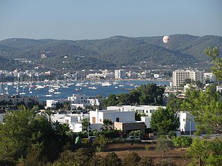
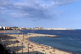
Sant Antoni de Portmany is a town on the western coast of Ibiza, the second-largest town and municipality on the island. It is situated on Sant Antoni Bay on the west coast of the island, part of the Spain autonomous community of the Balearic Islands.

Xàbia or Jávea is a coastal town and municipality in the comarca of Marina Alta, in the province of Alicante, Valencia, Spain, by the Mediterranean Sea. Situated on the side of the Montgó Massif, behind a wide bay and sheltered between two rocky headlands, the town has become a very popular small seaside resort and market town. Half of its resident population and over two thirds of its annual visitors are foreigners.

The Costa Daurada is an area on the coast of Catalonia, Spain, between Cunit and Alcanar on the Mediterranean Sea.

The Balearic Sea also known as Iberian Sea, is a body of water in the Mediterranean Sea between the Balearic Islands and mainland Spain. The Ebro River flows into this small sea.
Sant Jaume d'Enveja municipality in the comarca of the Montsià in Catalonia, Spain. It is situated in the southern half of the Ebro Delta, on the right bank of the river. The municipality was created in 1978: previously the territory formed part of the municipality of Tortosa. It is linked to Amposta by a local road, and to Deltebre on the opposite bank by a service of barges.
San Antonio de Benagéber, Valencian: Sant Antoni de Benaixeve, is a municipality in the comarca of Camp de Túria in the Valencian Community, Spain.

Cape Sant Antoni is a cape in the town of Xàbia, on the north coast of the Alacant Province in the Valencian Land, southeastern Spain. It is located north of the town proper, south of Dénia, and forms part of the southern edge of the Gulf of València, just before it ends at the more southerly Cap de la Nau. It is backed by the Montgó Mountain, of which it is actually an extension, geologically speaking, and ends in 170-meter-high cliffs. It is included in the Costa Blanca.

Rail transport in Catalonia operates on three rail gauges and services are operated by a variety of public operators:

Sant Antoni is a neighborhood in the Eixample district of Barcelona, Catalonia (Spain). Its non-official centre, the marketplace of the same name—designed by Antoni Rovira i Trias and built between 1872 and 1882—is one of the oldest and most popular in the city, especially with the secondhand book stalls that surround the building Sunday mornings. It is bordered by the neighbourhoods of the L'Antiga Esquerra de l'Eixample, the Raval, and Poble Sec. The streets of Sant Antoni follow the grid pattern prevalent in all of Eixample, except for a central thoroughfare, the Avinguda de Mistral, built on the site of an important medieval road which led out of Barcelona. Another well-known landmark of Sant Antoni is the bar called Els Tres Tombs, right next to the market.

Diagonal Mar i el Front Marítim del Poblenou is a neighborhood in the Sant Martí district of Barcelona, Catalonia, Spain.
The Ebro is a river of the north and northeast of the Iberian Peninsula, in Spain. It rises in Cantabria and flows 930 kilometres (580 mi), almost entirely in an east-southeast direction. It flows into the Mediterranean Sea, forming a delta in the Terres de l'Ebre region, in southern Catalonia. In the Iberian peninsula, it ranks second in length after the Tagus and second in discharge volume, and drainage basin, after the Douro. It is the longest river entirely within Spain; the other two mentioned flow into Portugal. It is also the second-longest river in the Mediterranean basin, after the Nile.

The Ebro Delta is the delta region of the Ebro River in the southwest of the Province of Tarragona in the region of Catalonia in Spain. It is located on the Mediterranean Sea, and is the northernmost point, by some designations, of the Gulf of Valencia. Its location per Ramsar site designation is 40°43′N0°44′E.

Sant Antoni de Portmany is a municipality on the North central coast of Ibiza. The municipality is situated on Sant Antoni Bay on the north west seaboard of the island, part of the Spanish autonomous community of the Balearic Islands.The total number of inhabitants in the municipality (2009) is 21,852.
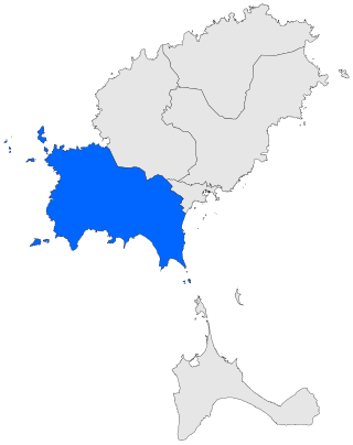
Sant Josep de sa Talaia is a municipality in the South West of Ibiza. The municipality is part of the Spanish autonomous community of the Balearic Islands. The total number of inhabitants in the municipality (2006) is 19,244.

Cala Comte is a beach in the south west of the Spanish island of Ibiza. It is in the municipality of Sant Josep de sa Talaia and is 5.0 miles (8.0 km) west of the village of Sant Agustí des Vedrà.
Illa des Bosc is a small uninhabited island of the north west seaboard of the Spanish island of Ibiza. It is within the municipality of Sant Josep de sa Talaia and is a short distance due north of the beach of Cala Comte. The island is 5.8 kilometres (3.6 mi) west of the town of Sant Antoni de Portmany and is one of the smaller islands of the Balearic archipelago.
Sant Antoni de Calonge is a town which forms part of the city of Calonge. It is located in the comarca of the Baix Empordà in Catalonia, Spain. The town was built along the rocky coastline of northern Spain. There is a seaside promenade that connects many neighboring towns. Sant Antoni de Calonge is between Platja d'Aro and Palamós.

Sant Pere de les Puelles is a Benedictine monastery in the Sant Pere, Santa Caterina i la Ribera neighborhood of the Ciutat Vella district of Barcelona, Catalonia, Spain. The 10th-century building, Romanesque/Gothic in style, was declared a Bien de Interés Cultural landmark in 1931.
