San Basilio (Spanish : Barrio de San Basilio) is one of the neighbourhoods in the Centro district of Córdoba, Spain. It is bordered by the River Guadalquivir to the southeast. [1] The district was specifically included in the Historic centre of Córdoba as part of the UNESCO World Heritage site. [2] Among its historic monuments are the Alcázar de los Reyes Cristianos and the Royal Stables of Córdoba.
Spanish or Castilian, is a Western Romance language that originated in the Castile region of Spain and today has hundreds of millions of native speakers in the Americas and Spain. It is a global language and the world's second-most spoken native language, after Mandarin Chinese.
The Guadalquivir is the fifth longest river in the Iberian Peninsula and the second longest river with its entire length in Spain. The Guadalquivir river is the only great navigable river in Spain. Currently it is navigable from the Gulf of Cádiz to Seville, but in Roman times it was navigable to Córdoba.
The historic centre of Córdoba, Spain is one of the largest of its kind in Europe. In 1984, UNESCO registered the Mosque–Cathedral of Córdoba as a World Heritage Site. A decade later, it expanded the inscription to include much of the old town. The historic centre has a wealth of monuments preserving large traces of Roman, Arabic, and Christian times.
San Basilio is named after the saint to whom the parish of Nuestra Señora de la Paz (Our Lady of Peace) was dedicated. It has a history going back to the years immediately following Córdoba's conquest by the Spaniards in 1236. At the beginning of the 15th century, it was decided to combat the city's lagging population by accommodating crossbowmen and their families there, especially as they could also man the surrounding defences. [3]
The quarter has three main streets which run parallel to each other: Postera, Enmedio and San Basilio. Unlike the winding streets elsewhere in the city centre, they are perfectly straight, introducing a more rational approach to urban planning. By contrast, the generally two-storey, whitewashed houses have an Arabic look, arranged as they are around central courtyards or patios forming a neighbourhood known as "Los Patios Cordobeses". From the late 14th century, the area was occupied by Jewish converts who created a ghetto. An attempt to banish them failed, thanks to mediation by the Catholic monarchs in 1479. However, as a result of poor sanitation, they were later moved to nearby San Nicolas de la Villa. [3]
One of the most interesting structures in San Basilio is the Torre de Belén, a fine example of a former defensive gate providing access to a walled enclosure. The parish Church of San Basilio, on the site of a monastery founded in 1590, is built in the 17th-century Baroque style with period furnishings. [4] The 18th-century convent "Cofradía de Nuestra Señora de la Paz" houses the richly decorated altarpiece from the former "Convento de Santa Clara". [3]
The Torre de Belén is located in the San Basilio neighbourhood of Córdoba, Spain. It forms part of the Historic centre of Córdoba, a UNESCO World Heritage site. The tower is a fine example of a former defensive gate providing access to a walled enclosure.
The Baroque is a highly ornate and often extravagant style of architecture, music, painting, sculpture and other arts that flourished in Europe from the early 17th until the mid-18th century. It followed the Renaissance style and preceded the Rococo and Neoclassical styles. It was encouraged by the Catholic Church as a means to counter the simplicity and austerity of Protestant architecture, art and music, though Lutheran Baroque art developed in parts of Europe as well. The Baroque style used contrast, movement, exuberant detail, deep colour, grandeur and surprise to achieve a sense of awe. The style began at the start of the 17th century in Rome, then spread rapidly to France, northern Italy, Spain and Portugal, then to Austria and southern Germany. By the 1730s, it had evolved into an even more flamboyant style, called rocaille or Rococo, which appeared in France and central Europe until the mid to late 18th century.
An altarpiece is an artwork such as a painting, sculpture or relief representing a religious subject made for placing behind the altar of a Christian church. Though most commonly used for a single work of art such as a painting or sculpture, or a set of them, the word can also be used of the whole ensemble behind an altar, otherwise known as a reredos, including what is often an elaborate frame for the central image or images. Altarpieces were one of the most important products of Christian art especially from the late Middle Ages to the era of the Counter-Reformation.
Córdoba, also called Cordova in English, is a city in Andalusia, southern Spain, and the capital of the province of Córdoba. It was a Roman settlement, taken over by the Visigoths, and then taken by Muslim armies in the eighth century. It became the capital of a Muslim emirate, and then of the Caliphate of Córdoba, which encompassed most of the Iberian Peninsula. During this period, it became a centre of education and learning, and by the 10th century had grown to possibly the largest city in Europe. It was recaptured by Christian forces in 1236, during the Reconquista.
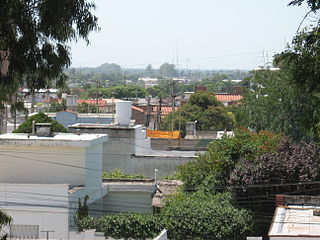
Alta Gracia is a city located in the north-centre of the province of Córdoba, Argentina. Its name means "High Grace". It is built upon the Sierras Chicas, in a region that the Comechingón Indians used to call Paravachasca. It has about 43,000 inhabitants.
Motril is a town and municipality on the Mediterranean coast in the province of Granada, Spain. It is the second largest town in the province, with a population of 60,368 as of 2016. The town is located near the Guadalfeo River and 69 km (43 mi) from Granada. The council of Motril includes the city of Motril and the neighbourhoods of El Varadero, Carchuna, Calahonda, Puntalón, Playa Granada, Las Ventillas, La Perla, La Garnatilla and La Chucha. The town is the capital of the region of the Coast of Granada.
Arcos de la Frontera is a town and municipality in the Sierra de Cádiz comarca, province of Cádiz, in Andalusia, Spain. It is located on the Northern, Western and Southern banks of the Guadalete river, which flows around three sides of the city under towering vertical cliffs, to Jerez and on to the Bay of Cádiz. The town commands a fine vista atop a sandstone ridge, from which the peak of San Cristóbal and the Guadalete Valley can be seen. The town gained its name by being the frontier of Spain's 13th century battle with the Moors.
The Alcázar de los Reyes Cristianos, also known as the Alcázar of Córdoba, is a medieval alcázar located in the historic centre of Córdoba, next to the Guadalquivir River and near the Grand Mosque. The Alcázar takes its name. The fortress served as one of the primary residences of Isabella I of Castile and Ferdinand II of Aragon.
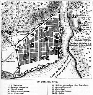
Ciudad Colonial is the historic central neighborhood of Santo Domingo and the oldest permanent European settlement of the Americas. It has been declared a World Heritage Site by UNESCO. It is also known as "Zona Colonial" or more colloquially as "La Zona". The Ciudad Colonial is located on the west bank of the Ozama River, which bisects the city. It covers 1.06 km2 (0.41 sq mi) bounded by a walled perimeter.
The Spanish missions in South America comprise a series of Jesuit Catholic religious outposts established by Spanish Catholics in order to spread the Christian doctrine among the local natives.
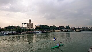
The Casco Antiguo is the city centre district of Seville, the capital of the Spanish region of Andalusia. It lies on the east bank of the Guadalquivir river. The Casco Antiguo borders the Macarena to the north, Nervión and San Pablo-Santa Justa to the east and the Distrito Sur to the south. Bridges across the Guadalquivir link the Casco Antiguo to Triana and Los Remedios on the Isla de La Cartuja.
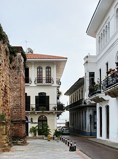
Casco Viejo, also known as Casco Antiguo or San Felipe, is the historic district of Panama City. Completed and settled in 1673, it was built following the near-total destruction of the original Panamá city, Panamá Viejo in 1671, when the latter was attacked by pirates. It was designated a World Heritage Site in 1997.
The Cathedral of Córdoba is the central church of the Roman Catholic Archdiocese of Córdoba, Argentina, and the oldest church in continuous service in Argentina.
Seville, the capital of the region of Andalusia in Spain, has 11 districts, further divided into 108 neighbourhoods.
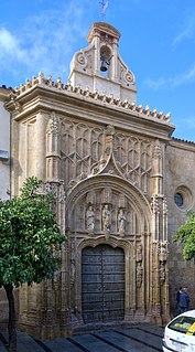
San Sebastián Hospital is a 16th-century building on Calle Torrijos in Córdoba, Spain. It is situated in the historic centre, just opposite the west front of the Mosque–Cathedral of Córdoba. Founded in 1363 in Alcayceria, it was moved in the early 16th century. Built to a design by Hernán Ruiz, el Viejo, construction on the current building occurred during the period of 1512-16. The building served as a hospital (1516-1816); a home for mothers and infants (1816-1961); and currently houses the Palace of Congresses and Exhibitions, as well as the Office of Tourism.
The Chapel of San Bartolomé is a funerary chapel in the historic centre of Córdoba, Spain. It is dated between 1390 and 1410. Richly decorated, it is one of the city's finest examples of Mudéjar art.
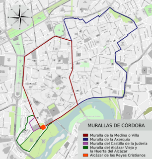
The Roman Walls which once surrounded Córdoba, Spain, were built after the Romans captured the city in 206 BC, making it part of the Roman Republic. The walls now form part of the historic centre of Córdoba, a UNESCO World Heritage site.
Santa María Magdalena is a church in Córdoba, Spain, built in the Mudejar style. It forms part of the Historic centre of Córdoba, a UNESCO World Heritage site.
Wikimedia Commons has media related to San Basilio, Córdoba . |
Coordinates: 37°52′30″N04°47′00″W / 37.87500°N 4.78333°W
A geographic coordinate system is a coordinate system that enables every location on Earth to be specified by a set of numbers, letters or symbols. The coordinates are often chosen such that one of the numbers represents a vertical position and two or three of the numbers represent a horizontal position; alternatively, a geographic position may be expressed in a combined three-dimensional Cartesian vector. A common choice of coordinates is latitude, longitude and elevation. To specify a location on a plane requires a map projection.