
San Clemente Canyon is a canyon located in the city of San Diego, in San Diego County, California.
Marian Bear Memorial Park, a linear open space park, is along the canyon and in the southern tributary arroyos and mesa. [1]
San Clemente Canyon is a canyon located in the city of San Diego, in San Diego County, California.
Marian Bear Memorial Park, a linear open space park, is along the canyon and in the southern tributary arroyos and mesa. [1]
The canyon and Marian Bear Memorial Park parallels the San Clemente Canyon Freeway (State Route 52) (along northern canyon slopes), between its junctions with Interstate 5 (on west) and Interstate 805 (on east) at the ends. [2]
The park provides a natural setting in the midst of a busy urban area. The 467 acres (189 ha) of dedicated natural parkland include finger canyons and mesas on the south side. [3]
The main canyon and its tributaries continue to support a population of resident wildlife including raccoons, skunks, rabbits, amphibians, reptiles, and birds, and serve as a pathway for coyote, fox, and other native mammals. [3] Along the length of the canyon are coast live oak, California sycamore, and native willow tree woodlands, with an undergrowth of native and other plant species. [3] The chaparral and riparian California native plant communities are closely defined by their microclimates and underlying soils. [3]
The Native American Kumeyaay people had historically inhabited the area of San Diego County for 10,000 years and was home to a Kumeyaay village called Onap, at the intersection of the San Clemente Canyon and Rose Canyon. [4] Evidence of their presence still remains in San Clemente Canyon. [3]
In the late 19th century, this area was named Clemente Canyon for a native American rancher. During the 1970s its natural ecosystem and habitats were threatened by plans to place the San Clemente Canyon Freeway (State Route 52) along the canyon floor. [3]
Marian Bear, an active community leader and environmentalist, worked to preserve the canyon in its natural state. She was the driving force behind realigning the highway from the canyon floor to the north hillsides above it. [3] In the 1980s another community campaign resulted in an additional 72 acres in the southeast section added, for the present total of 467 acres. [3]
Over 40 million years ago an ocean covered San Clemente Canyon during the Eocene epoch of the Paleogene period. Horizontal lines of round rocks at many levels, separated by clay and sand, represent the various levels of the ocean washing sand away and leaving rocks at surf level.
Fossilized mollusks, such as snails and clams from that period are still found in the canyon's walls. The fossils are preserved in the sandstones and siltstones of the Scripps Formation that is best exposed in the roadcuts along Regents Road and Genesee Avenue.
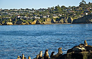
San Diego is a city in the U.S. state of California located alongside the Pacific Ocean in Southern California. With a population of over 1.3 million residents, the city is the eighth-most populous in the United States and the second-most populous in California after Los Angeles. The city is located immediately adjacent to the Mexico–United States border and is the seat of San Diego County, which has a population of nearly 3.3 million people as of 2021. San Diego is known for its mild year-round Mediterranean climate, extensive beaches and parks, its long association with the United States Navy, and its recent emergence as a healthcare and biotechnology development center.
Mira Mesa is a community and neighborhood in the city of San Diego, California. The city-recognized Mira Mesa Community Plan Area is roughly bounded by Interstate 15 on the east, Interstate 805 on the west, the Los Peñasquitos Canyon on the north and Marine Corps Air Station Miramar on the south. Most of the community plan area is referred to as Mira Mesa; the community plan area also includes the neighborhoods of Sorrento Valley and Sorrento Mesa.

State Route 52 (SR 52) is a state highway in San Diego County, California, that extends from La Jolla Parkway at Interstate 5 (I-5) in La Jolla, San Diego, to SR 67 in Santee. It is a freeway for its entire length and serves as a major east–west route through the northern part of the city of San Diego. The road connects the major north–south freeways of the county, including I-5, I-805, SR 163, I-15, SR 125, and SR 67. SR 52 passes north of the Rose Canyon Fault before traversing Marine Corps Air Station Miramar. East of Santo Road and west of SR 125, the highway goes through Mission Trails Regional Park, a large open preserve. SR 52 is also known as the Soledad Freeway and the San Clemente Canyon Freeway.
Rose Creek is an urban stream in San Diego, California that drains to Mission Bay. It flows in a north-to-south direction through Rose Canyon and San Clemente Canyon and their tributary canyons. Both Rose Creek and Rose Canyon are named for San Diego pioneer Louis Rose, who had a ranch in the canyon in the 1850s.

The Southern California freeways are a vast network of interconnected freeways in the megaregion of Southern California, serving a population of 23 million people. The Master Plan of Metropolitan Los Angeles Freeways was adopted by the Regional Planning Commission in 1947 and construction began in the early 1950s. The plan hit opposition and funding limitations in the 1970s, and by 2004, only some 61% of the original planned network had been completed.

The Cleveland National Forest encompasses 460,000 acres/720 sq mi (1,900 km2) of inland montane regions—approx. 60 miles from the Pacific Ocean—within the counties of San Diego, Riverside, and Orange, California. The landscape varies somewhat, with mostly chaparral canyons, arroyos and high desert, but dotted with meadows and oak and conifer forests. Near water sources, riparian environments and perennial aquatic plants attract native and migratory wildlife, such as at San Diego’s man-made Lake Cuyamaca. A generally warm and dry, inland-Mediterranean climate prevails over the forest, with the cooler months producing morning frost and snowfall. It is the southernmost U.S. National Forest of California. The area is administered by the U.S. Forest Service, a government agency within the United States Department of Agriculture, and is locally overseen by the Descanso, Palomar and Trabuco Ranger Districts.
City Heights is a dense urban community in central San Diego, California, known for its ethnic diversity. The area was previously known as East San Diego. City Heights is located south of Mission Valley and northeast of Balboa Park.

Sorrento Valley is a neighborhood of San Diego, California. It is located about 17 mi (27 km) north of Downtown San Diego and its main airport, Lindbergh Field. It is roughly bounded by Interstate 5 and Interstate 805, Camino Santa Fe to the east, the Los Peñasquitos Canyon Preserve to the north and Miramar Road to the south, as shown on the San Diego Police Department's neighborhood map. It encompasses Sorrento Mesa and is part of the San Diego Unified School District.

Carmel Valley is a suburban planned community in the northwestern corner of San Diego, California, United States. The community is composed of commercial offices, residential units, hotels, retail stores and restaurants.


Rancho Bernardo is a master-planned community in the northern hills of the city of San Diego, California.
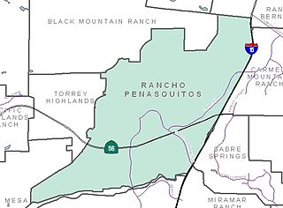
Rancho Peñasquitos is a suburban community in the northeastern part of the city of San Diego, California. It is named after the first Mexican land grant in the county, Rancho Santa Maria de Los Peñasquitos. The community abuts Los Peñasquitos Canyon Preserve, an open space preserve that offers hiking, biking, and equestrian trails. The community is commonly abbreviated "PQ."

University City (UC) is a community in San Diego, California, located in the northwestern portion of the city next to the University of California, San Diego. University City is bordered by La Jolla and Interstate 5 to the west, Miramar and Interstate 805 to the east, and North Clairemont and Highway 52 to the south, giving the community a triangular-shaped boundary. University City is a part of District 1, which is represented by Councilmember Joe LaCava on the San Diego City Council.

Serra Mesa is a community in San Diego, California, roughly between Interstate 805 and Interstate 15, north of Friars Road and south of Aero Drive. It is named for Junípero Serra, a Majorcan (Spain) Franciscan friar who founded the Mission San Diego de Alcalá. Adjacent communities include Kearny Mesa, Tierrasanta, Mission Valley, and Linda Vista.

Clairemont is a community within the city of San Diego, California, United States. It has a population of about 81,600 residents and an area of roughly 13.3 square miles (34 km2). Clairemont Mesa is bordered by Interstate 805 on the east, Interstate 5 to the west, State Route 52 to the north, and the community of Linda Vista to the south. The community of Clairemont Mesa can be subdivided into the neighborhoods of North Clairemont, Clairemont Mesa East, Clairemont Mesa West, Bay Park, and Bay Ho.

Torrey Hills is a community of 784 acres (317 ha) located in northern San Diego, California, United States. Torrey Hills is a part of District 1 which is represented by Councilmember Joe LaCava on the San Diego City Council.
Rancho Santa Maria de Los Peñasquitos was a 8,486-acre (34.34 km2) Mexican land grant in present-day southwestern San Diego County, California given in 1823 to Francisco María Ruiz. The name means "Saint Mary of the Little Cliffs". It encompassed the present-day communities of Mira Mesa, Carmel Valley, and Rancho Peñasquitos in northern San Diego city, and was inland from the Torrey Pines State Natural Preserve bluffs.

Santiago Creek is a major watercourse in Orange County in the U.S. state of California. About 34 miles (55 km) long, it drains most of the northern Santa Ana Mountains and is a tributary to the Santa Ana River. It is one of the longest watercourses entirely within the county. The creek shares its name with Santiago Peak, at 5,687 ft (1,733 m) the highest point in Orange County, on whose slopes its headwaters rise.

San Mateo Creek is a stream in Southern California in the United States, whose watershed mostly straddles the border of Orange and San Diego Counties. It is about 22 miles (35 km) long, flowing in a generally southwesterly direction. Draining a broad valley bounded by the Santa Ana Mountains and Santa Margarita Mountains, San Mateo Creek is notable for being one of the last unchannelized streams in Southern California.

Balboa Park is a 1,200-acre (490 ha) historic urban cultural park in San Diego, California, United States. In addition to open space areas, natural vegetation zones, green belts, gardens, and walking paths, it contains museums, several theaters, and the San Diego Zoo. There are also many recreational facilities and several gift shops and restaurants within the boundaries of the park. Placed in reserve in 1835, the park's site is one of the oldest in the United States dedicated to public recreational use. Balboa Park is managed and maintained by the Parks and Recreation Department of the City of San Diego.