
Omoa is a town and municipality with a population of 10,550 in the Department of Cortés in Honduras. Omoa is located on a small bay of the same name 18 km west of Puerto Cortés on the Caribbean Sea coast.
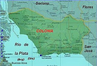
Colonia is a department of southwestern Uruguay. Its capital is Colonia del Sacramento, the country's second oldest city.
El Triunfo is a town, with a population of 10,930, and a municipality in the Honduran department of Choluteca.

San José is a municipality in the Honduran department of Choluteca.
Santa Rita is a municipality in the Honduran department of Copán.

Cedros is a municipality in the Honduran department of Francisco Morazán.

Santa Lucía is a municipality in the Honduran department of Francisco Morazán.
San Isidro is a municipality in the Honduran department of Intibucá.
San Marcos de la Sierra is a municipality in the Honduran department of Intibucá.
Santa Elena is a municipality in the Honduran department of La Paz.
Santiago de Puringla is a municipality in the Honduran department of La Paz. The municipality is situated on a plain bordered by the River Puringla. South of the municipality runs the River Lepasale.

Gualcince is a municipality in the Honduran department of Lempira.

San Sebastián is a municipality in the Honduran department of Lempira.
Concepción is a municipality in the Honduran department of Ocotepeque.
La Labor is a municipality in the Honduran department of Ocotepeque.

Ocotepeque is a municipality in the Honduran department of Ocotepeque. The town of Nueva Ocotepeque is the municipal seat and the capital of the department.
San Jorge is a municipality in the Honduran department of Ocotepeque.
San Marcos is a town, with a population of 6,836, and a municipality in the Honduran department of Ocotepeque.

Cilleros is a municipality located in the province of Cáceres, Extremadura, Spain. According to the 2006 census (INE), the municipality has a population of 1962 inhabitants. It is the birthplace of Real Madrid footballer, Fernando Morientes.
The Taku River Tlingit First Nation are the band government of the Inland Tlingit in far northern British Columbia, Canada and also in Yukon. They comprise two ḵwaan (tribes) of the Tlingit people, who are otherwise coastal, the Áa Tlein Ḵwáan of the Atlin Lake area and the Deisleen Ḵwáan of Teslin Lake, whose main focus is the Teslin Tlingit Council in Teslin, Yukon. Their band offices are in Atlin, British Columbia.

