
Alameda County is a county in the state of California in the United States. As of the 2010 census, the population was 1,510,271, making it the 7th-most populous county in the state. and 20th most populous nationally. The county seat is Oakland. Alameda County is included in the San Francisco Bay Area, occupying much of the East Bay region.

Scouting in California has a long history, from the 1910s to the present day, serving thousands of youth in programs related to their environments.

Livermore is a city in Alameda County, California, in the United States. With an estimated 2019 population of 90,189, Livermore is the most populous city in the Tri-Valley. Livermore is located on the eastern edge of California's San Francisco Bay Area. The incumbent Mayor of Livermore is John Marchand.

Pleasanton is a city in Alameda County, California, incorporated in 1894. It is a suburb in the San Francisco Bay Area located about 25 miles (40 km) east of Oakland, and 6 miles (9.7 km) west of Livermore. The population was 70,285 at the 2010 census. In 2005 and 2007, Pleasanton was ranked the wealthiest middle-sized city in the United States by the Census Bureau. Pleasanton is home to the headquarters of Safeway, Workday, Ellie Mae, Roche Molecular Diagnostics, Blackhawk Network Holdings, and Veeva Systems. Other major employers include Kaiser Permanente, Oracle, Nordstrom and Macy's. Although Oakland is the Alameda County seat, a few county offices are located in Pleasanton. The Alameda County Fairgrounds are located in Pleasanton, where the county fair is held during the last week of June and the first week of July. Pleasanton Ridge Regional Park is located on the west side of town.
Interstate 680 (I-680) is a major north–south auxiliary Interstate Highway in Northern California. It curves around the eastern cities of the San Francisco Bay Area from San Jose to Interstate 80 at Fairfield, bypassing cities along the eastern shore of San Francisco Bay such as Oakland and Richmond while serving others more inland such as Pleasanton and Concord.

State Route 123 is a state highway in the U.S. state of California in the San Francisco Bay Area. Named San Pablo Avenue for virtually its entire length, SR 123 is a major north–south state highway along the flats of the urban East Bay. Route 123 runs about 7.39 miles (11.9 km) between Interstate 580 in Oakland in the south and Interstate 80 in Richmond in the north. San Pablo Avenue itself, a portion of Historic US 40, continues well past these termini, south to Downtown Oakland and north to Crockett, but without the Route 123 designation.

Niles Canyon is a canyon in the San Francisco Bay Area formed by Alameda Creek, known for its heritage railroad and silent movie history. The canyon is largely in an unincorporated area of Alameda County, while the western portion of the canyon lies within the city limits of Fremont and Union City. The stretch of State Route 84 known as Niles Canyon Road traverses the length of the canyon from the Niles district of Fremont to the unincorporated town of Sunol. Two railroads also follow the same route down the canyon from Sunol to Niles: the old Southern Pacific track along the north side, now the Niles Canyon Railway, and the newer Union Pacific track a little to the south. At the west end of the canyon are the ruins of the Vallejo Flour Mill, which dates to 1853.
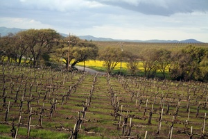
The Livermore Valley AVA is an American Viticultural Area in Alameda County, California, surrounding the city of Livermore in the Tri-Valley region. Both the AVA and the city are named after Robert Livermore, a landowner whose holdings encompassed the valley. The groundwater basin underlying the valley is the Livermore Basin, the largest sub-unit of which is the Mocho Subbasin. The Livermore Basin is one of five aquifers in the San Francisco Bay Area that supply most of the metropolitan Bay Area population. The entire Livermore Basin aquifer faces a concern over elevated total dissolved solids by the year 2020 due to an expanding human population leading to higher rates of return water flows to the aquifer containing certain salts.
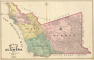
Murray Township was a township located in what is now the Livermore Valley portion of Alameda County, California, including the present day cities of Livermore, Dublin, and Pleasanton, and the census-designated place of Sunol.
Eden Township is a former township of Alameda County, California in the San Francisco Bay Area region, which includes the present-day cities of Hayward and San Leandro, as well as the unincorporated census-designated areas of Ashland, Castro Valley, Cherryland, Fairview, and San Lorenzo. It was created from a group of Mexican land grants that were added to Alameda County when the county was established in 1853. Today there are several public and private agencies serving the region.
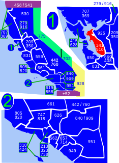
Area codes 510 and 341 are telephone area code in the North American Numbering Plan (NANP) serving much of the East Bay in California. They cover parts of Contra Costa County and western Alameda County, including the city of Oakland, but excluding Dublin, Livermore, Pleasanton, and Sunol.

Arroyo Mocho is a 34.7-mile-long (55.8 km) stream which originates in the far northeastern corner of Santa Clara County and flows northwesterly into eastern Alameda County, California. After traversing the cities of Livermore and Pleasanton it joins South San Ramon Creek to become Arroyo de la Laguna, which in turn flows to Alameda Creek and thence to San Francisco Bay.
One of the six Boy Scouts of America councils that serves the San Francisco Bay area, the Pacific Skyline Council was founded in 1940 as the Stanford Area Council (#031). In 1994, the Stanford Area Council merged with the San Mateo County Council (#020) to form the current council which serves youth in San Mateo County and northern Santa Clara county.
Livermore Valley, formerly Valle De San Jose, is a valley in eastern Alameda County, in the East Bay region of the San Francisco Bay Area, northern California.
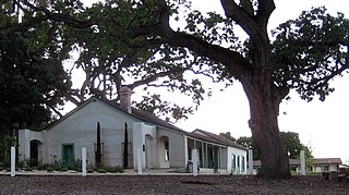
The Alviso Adobe Community Park is a 7-acre (2.8 ha) park in the city of Pleasanton, California, United States. It is built around an adobe house constructed in 1854 by Francisco Alviso on the Rancho Santa Rita Mexican Land Grant. The Alviso Adobe is a rare surviving example of an early American adobe that was continuously in use until 1969. The building is registered as California Historical Landmark #510 in 1954, but most of the historical marker was later found to be erroneous.

The Atlanta Area Council is a local council of the Boy Scouts of America. It serves 13 northern Georgia counties: Carroll, Cherokee, Clayton, Cobb, DeKalb, Douglas, Fulton, Gwinnett, Haralson, Newton, Paulding, Pickens, and Rockdale.

Mount Diablo Silverado Council is a local council of the Boy Scouts of America (BSA) and is one of six councils that serves the San Francisco Bay area in California. The council's office is located in Pleasant Hill, California. It serves chartered organizations and BSA units in Contra Costa County, Lake County, Napa County, Solano County, and the cities of Albany and Berkeley in northern Alameda County. The council is located in BSA Western Region Area III.
El Camino Viejo a Los Ángeles, also known as El Camino Viejo and the Old Los Angeles Trail, was the oldest north-south trail in the interior of Spanish colonial Las Californias (1769–1822) and Mexican Alta California (1822–1848), present day California. It became a well established inland route, and an alternative to the coastal El Camino Real trail used since the 1770s in the period.

THE Alameda County Fire Department (ACFD) provides all-risk emergency services to the unincorporated areas of Alameda County, California, the cities of San Leandro, Dublin, Newark, Union City and Emeryville, the Lawrence Berkeley National Laboratory and the Lawrence Livermore National Laboratory. With 29 fire stations and 35 companies serving a population of 394,000, the ACFD serves densely populated urban areas, waterways, industrialized centers, extensive urban interface, agricultural and wildland regions. Over 400 personnel and 100 Reserve Firefighters provide a wide variety of services to an ever expanding, dynamic and diverse community of roughly 508 square miles (1,320 km2) in size.
