
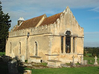
San Lorenzo in Nifili is a Romanesque-style, Roman Catholic church located near the village of Farnetta, part of the commune of Montecastrilli, in the province of Terni, region of Umbria, Italy.
San Lorenzo in Nifili is a Romanesque-style, Roman Catholic church located near the village of Farnetta, part of the commune of Montecastrilli, in the province of Terni, region of Umbria, Italy.
This church is isolated in the Umbrian countryside and it was constructed here because an important route connecting Amelia to Todi and Carsulae passed in front of the Church since Roman times. The church is documented since 1112, when it was donated by the Count Rapizzo degli Arnolfi to the Abbey of Farfa. [1] The church incorporates spolia from an ancient Roman construction. In medieval times, a small community of monks lived in the building adjacent to the Church, while the arable fields around it were rented to the noble families of Todi. The importance of the route passing in front of the church reduced with time, and the monastic community was replaced by families of farmers. In 1777, it became part of the parish of Farnetta together with its fields (65 hectares). [2] The ownership of the church and the arable fields passed in 1986 from the parish of Farnetta to the diocese of Orvieto-Todi. An oil painting from the 17th century, now in the church of Farnetta, showing the martyrdom of St. Laurence, was placed on the main altar. The church has some interesting frescoes from the 15th century. Of particular interest is the travertine altar, made with Roman stone, where it can be read the inscription "A. D. M" (Anno Domini Mille, year 1,000). Every year, on the 10th of August, st. Laurence day, the local community of Farnetta and Montecastrilli celebrates the saint with a religious mass, typical food and wine.

Todi is a town and comune (municipality) of the province of Perugia in central Italy. It is perched on a tall two-crested hill overlooking the east bank of the river Tiber, commanding distant views in every direction. It was founded in antiquity by the Umbri, at the border with Etruria; the family of Roman Emperor Trajan came from Todi.

Llanddoged is a small village which lies in the hills a little over a mile to the north of Llanrwst, in Conwy county borough, Wales. The village itself has a small population, with a surrounding rural farming community. Most of the population are Welsh speakers. Llanddoged shares its community council with the rural community of Maenan. Llanddoged has two small hamlets attached to it - Groesffordd and Tan-Lan. Groesffordd has a motor repair garage known as 'Garej Groesffordd'. Tan-lan was known for its notorious bends on the A470 where, before road improvements, many road traffic collisions had occurred. Tan-lan is also home to an Environment Agency Wales depot.

Stonesfield is a village and civil parish about 5 miles (8 km) north of Witney in Oxfordshire, and about 10 miles (17 km) north-west of Oxford. The village is on the crest of an escarpment. The parish extends mostly north and north-east of the village, in which directions the land rises gently and then descends to the River Glyme at Glympton and Wootton about 3 miles (5 km) to the north-east. South of Stonesfield, below the escarpment, is the River Evenlode which touches the southern edge of the parish. At the centre of Stonesfield stands the 13th-century church of St James the Great as well as a Wesleyan chapel, Stonesfield Methodist Church, slightly further west. The village is known for Stonesfield slate, a form of Cotswold stone mined particularly as a roofing stone and also a rich source of fossils. The architecture in Stonesfield features many old Cotswold stone properties roofed with locally mined slate along with some late 20th-century buildings and several properties under construction. The 2011 Census recorded the parish's population as 1,527.

Adwick le Street is a village in the City of Doncaster, South Yorkshire, England. The Adwick ward of Doncaster Metropolitan Borough Council had a population of 15,911 at the 2011 Census. It is situated north-west of Doncaster. Under the 2011 census, the settlement had a population of 10,507.

Ribchester is a village and civil parish within the Ribble Valley district of Lancashire, England. It lies on the banks of the River Ribble, six miles (10 km) northwest of Blackburn and twelve miles (19 km) east of Preston.

Brewood is an ancient market town in the civil parish of Brewood and Coven, in the South Staffordshire district, in the county of Staffordshire, England. Located around grid reference SJ883088, Brewood lies near the River Penk, eight miles north of Wolverhampton city centre and eleven miles south of the county town of Stafford. A few miles to the west of Brewood is the border with the county of Shropshire.

Stretton en le Field is a small village and civil parish in the North West Leicestershire district of Leicestershire, England, about 7 miles/11 km south-west of Ashby de la Zouch, historically an exclave of Derbyshire. According to the 2001 census, the parish had a population of 36. At the 2011 census the population remained under 100 and so was included in the civil parish of Chilcote. Stretton Bridge carries the A444 road across the River Mease, which forms the northern parish boundary. It is among the Thankful Villages, suffering no Great War fatalities in 1914–1918: eleven men went from the village to fight and all returned.

Sedgeford is a village and civil parish in the English county of Norfolk, about 5 miles south of the North Sea and 3 miles (4.8 km) east of the Wash. It is 36 miles north-west of Norwich. Its area of 6.6 square miles (17 km2) had a population, including Fring, of 613 at the 2011 Census. It was estimated at 601 in 2019. For local-government purposes, it falls within the district of King's Lynn and West Norfolk. It lies in a farming valley with main crops of barley, wheat and sugar beat, in a belt of chalk with the small Docking River running through.

Sloley is a village and a civil parish in the English county of Norfolk. The village is 11.9 miles (19.2 km) north-north-east of Norwich, 13.6 miles (21.9 km) south-south-east of Cromer and 128 miles (206 km) northeast of London. The village lies 4.7 miles (7.6 km) south of the town of North Walsham. Worstead railway station, on the Bittern Line between Cromer and Norwich, is about 1 km (0.62 mi) from the centre of the village. The nearest airport is Norwich International Airport. The parish had a population of 257 at the 2011 Census.

Chapelizod is a village preserved within the city of Dublin, Ireland. It lies in the wooded valley of the River Liffey, near the Strawberry Beds and the Phoenix Park. The village is associated with Iseult of Ireland and the location of Iseult's chapel. Chapelizod is under the administration of Dublin City Council.
Wheatfield is a civil parish and deserted medieval village about 4 miles (6.4 km) south of Thame in Oxfordshire. Wheatfield's toponym is derived from the Old English for "white field", referring to the ripe crops that the Anglo-Saxons grew on its fertile land. Few of Wheatfield's buildings remain today except the Church of England parish church of Saint Andrew, the former rectory and the former outbuildings of the no-longer-standing manor house.

Walluf is a municipality in the Rheingau-Taunus-Kreis in the Regierungsbezirk of Darmstadt in Hesse, Germany. With 5,581 residents in its 6.74 square kilometer area, it is the most densely populated community in the Rheingau-Taunus-Kreis.

Sutton is a village and civil parish near Dover in Kent, England. In 1935 this village became a parish when the small settlements of Studdal, Sutton, Ashley, Little Mongeham and Maydensole joined to become the Parish of Sutton-by-Dover. Prior to this Sutton has had a vast history of agricultural practices, which has helped sustain the village into the parish it is today. The quoted population includes the villages of East and West Studdal plus Swingate and the hamlet of Little Mongeham.

Arvieux is a commune of the Hautes-Alpes department in the Provence-Alpes-Côte d'Azur region of south-eastern France.

St. Jean Baptiste Roman Catholic Church, also known as the Église St-Jean-Baptiste, is a parish church in the Roman Catholic Archdiocese of New York at the corner of Lexington Avenue and East 76th Street in the Lenox Hill neighborhood of the Upper East Side of Manhattan, New York City. The parish was established in 1882 to serve the area's French Canadian immigrant population and remained the French-Canadian National Parish until 1957. It has been staffed by the Fathers of the Blessed Sacrament since 1900.

Farnetta is a small village in the Terre Arnolfe countryside, 16 miles northwest of the Italian city of Terni, Umbria. It is included in the comune of Montecastrilli in the province of Terni. It has a population of 283.

Caversfield is a village and civil parish about 1+1⁄2 miles (2.4 km) north of the centre of Bicester. In 1844 Caversfield became part of Oxfordshire, but until then it was always an exclave of Buckinghamshire. The 2011 Census recorded the parish's population as 1,788.

Souldern is a village and civil parish in Oxfordshire about 7 miles (11 km) northwest of Bicester and a similar distance southeast of Banbury. The parish is bounded to the west by the River Cherwell and to the east by field boundaries. Its northern boundary is Ockley Brook, a tributary of the Cherwell that forms the county boundary with Northamptonshire. The parish's southern boundaries are the main road between Bicester and Adderbury and the minor road between Souldern and Somerton. The 2011 Census recorded the parish's population as 370.

The Church of St Laurence is a Roman Catholic church in Cambridge, England. Dedicated to St Laurence of Rome, it is part of the Diocese of East Anglia, within the Province of Westminster. The parish is part of St Andrew's Deanery and is one of three parishes serving the city of Cambridge, the other two being Our Lady and the English Martyrs and St Philip Howard.

Todi Cathedral is a mainly Gothic-style Roman Catholic cathedral in Todi, Umbria, Italy, dedicated to the Annunciation of the Virgin Mary. It was formerly the seat of the bishops of Todi, and since 1986 has been a co-cathedral of the diocese of Orvieto-Todi.
This article about a church building or other Christian place of worship in Italy is a stub. You can help Wikipedia by expanding it. |