
Big Bend National Park is an American national park located in West Texas, bordering Mexico. The park has national significance as the largest protected area of Chihuahuan Desert topography and ecology in the United States, and was named after a large bend in the Rio Grande/Río Bravo. The park protects more than 1,200 species of plants, more than 450 species of birds, 56 species of reptiles, and 75 species of mammals. Additional park activities include scenic drives, programs led by Big Bend park rangers, and stargazing.
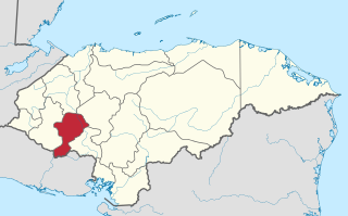
Intibucá is one of the 18 departments in the Republic of Honduras. Intibucá covers a total surface area of 1,186.1 square miles (3,072 km2). Its capital is the city of La Esperanza, in the municipality of La Esperanza.
Emiliano Zapata is a city in the west-central part of the Mexican state of Morelos. It stands at 18°52′N99°09′W. The city serves as the county seat for the surrounding municipality of the same name. The municipality is the sixth largest in the state of Morelos, with a 2020 census population of 107,053 inhabitants, and has it an area of 64.983 km2. The city of Emiliano Zapata had 64,084 inhabitants in 2020. The city was previously known as both San Francisco Zacualpan and San Vicente Zacualpan. It was renamed in honor of Mexican Revolutionary Emiliano Zapata.

Atlas Fútbol Club is a Mexican football club. It plays home matches at the Estadio Jalisco, Guadalajara, Jalisco.

Vicente José Matías Vuoso is a former professional footballer who played as a striker. Born in Argentina, he has previously represented the Mexico national team.

Mexico, officially the Municipality of Mexico, is a 1st class municipality in the province of Pampanga, Philippines. According to the 2020 census, it has a population of 173,403 people. It was also formerly known as Nuevo México during the Spanish period.

The San Diego River is a river in San Diego County, California. It originates in the Cuyamaca Mountains northwest of the town of Julian, then flows to the southwest until it reaches the El Capitan Reservoir, the largest reservoir in the river's watershed at 112,800 acre-feet (139,100,000 m3). Below El Capitan Dam, the river runs west through Santee and San Diego. While passing through Tierrasanta it goes through Mission Trails Regional Park, one of the largest urban parks in America. The river discharges into the Pacific Ocean near the entrance to Mission Bay, forming an estuary.

Vicente Filisola was a Spanish military figure, Mexican military and political figure in the 19th century.

Mission San Vicente was founded in August 1780 by the Dominican missionaries Miguel Hidalgo and Joaquin Valero among the Paipai Indians of northwestern Baja California, Mexico.

Moravia is the fourteenth canton in the San José province of Costa Rica. The head city of the canton is San Vicente.

Rancho Los Encinos was a Spanish grazing concession, and later Mexican land granted cattle and sheep rancho and travelers way-station on the El Camino Real in the San Fernando Valley, in present-day Encino, Los Angeles County, California. The original 19th-century adobe and limestone structures and natural warm springs are now within the Los Encinos State Historic Park.

The following is an alphabetical Mexico-related index of topics related to the United Mexican States.

Rancho La Providencia was a 4,064-acre (16.45 km2) Mexican land grant in present-day Los Angeles County, California given by governor Juan B. Alvarado in 1843 to Vincente de la Osa. The majority of Rancho Providencia land north of the modern channel of the Los Angeles River is now part of Burbank. The street grid change along Burbank Boulevard marks the northwestern boundary of the rancho grant. The Walt Disney Studios, Warner Bros. Studios, NBC Studios Burbank, Providence High School, and Providence Saint Joseph Medical Center are all within the former boundaries of Rancho Providencia. The Burbank Equestrian Center and portions of the Rancho south of the river are now part of the city of Los Angeles.

Tezonapa is a municipality located in the high mountains region in the State of Veracruz, Mexico, about 219 km from state capital Xalapa. It covers an area of 351 square kilometres (136 sq mi). The law number 93 of December 22, 1960 San Agustín created Tezonapa's municipality with the congregations of the Josefinas, Prison, Tezonapa, Palmarito, etc.

The Soto La Marina River or Soto la Marina is a river of northeastern Mexico.
The Playa Vicente River is a river of Mexico.
Vicente Álvarez Travieso (1705–1779) was a Spanish judge and politician who served as the first alguacil of San Antonio, Texas, from 1731 until his death. He was a leading spokesperson of the Canary Islands settlers of San Antonio and was noted for his support for the Isleño community there. Through his demands to the leaders of New Spain, Travieso was able to improve the lives of the Isleños. He was instrumental in providing medical care for them, thus ensuring their survival. Travieso became mayor of San Antonio in 1776.

Tropical Storm Vicente was an unusually small tropical cyclone that made landfall as a tropical depression in the Mexican state of Michoacán on October 23, 2018, causing deadly mudslides. The 21st named storm of the 2018 Pacific hurricane season, Vicente originated from a tropical wave that departed from Africa's western coast on October 6. The wave traveled westward across the Atlantic and entered the Eastern Pacific on October 17. The disturbance became better defined over the next couple of days, forming into a tropical depression early on October 19. Located in an environment favorable for further development, the system organized into Tropical Storm Vicente later that day.
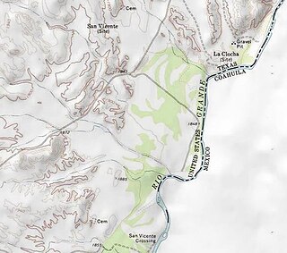
San Vicente was a village located in Brewster County, Texas within the protruding big bend of the Rio Grandé river. The village was geographically 1.5 miles (2.4 km) north of the San Vicente Crossing in present-day Big Bend National Park. The uninhabited site provides a panoramic view of the Chisos Mountains and the Sierra San Vicente migrating into Northern Mexico.
