 View of Sand Island, 2019 | |
 Sand Island | |
| Geography | |
|---|---|
| Location | Columbia River |
| Coordinates | 45°33′12″N122°12′09″W / 45.5534°N 122.2024°W |
| Administration | |
United States | |
| State | Oregon |
Sand Island is a dune-covered island in the Columbia River, [1] and part of Rooster Rock State Park. [2]
 Wooden structure on the island
 2019
2019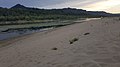 View of the mainland from the island
 View of the island from Bridal Veil Overlook


