
Sandy Township is a township in Saint Louis County, Minnesota, United States. The population was 356 at the 2010 census.

The Cannon River a tributary of the Mississippi River flows 112 miles (180 km) from Lake Tetonka near Waterville to Red Wing in the U.S. state of Minnesota, where it joins the Mississippi River. It drains a watershed approximately 1460 square miles (3,780 km²) in size. The river flows through the counties of Le Sueur, Rice, Dakota, and Goodhue.
Sand Creek may refer to a location in the United States:

The Driftless Area is a region in southwestern Wisconsin, southeastern Minnesota, northeastern Iowa, and the extreme northwestern corner of Illinois, of the American Midwest. The region escaped the flattening effects of glaciation during the last ice age and is consequently characterized by steep, forested ridges, deeply carved river valleys, and karst geology characterized by spring-fed waterfalls and cold-water trout streams. Ecologically, the Driftless Area's flora and fauna are more closely related to those of the Great Lakes region and New England than those of the broader Midwest and central Plains regions. Colloquially, the term includes the incised Paleozoic Plateau of southeastern Minnesota and northeastern Iowa. The region includes elevations ranging from 603 to 1,719 feet at Blue Mound State Park, and covers 24,000 square miles (62,200 km2). The rugged terrain is due both to the lack of glacial deposits, or drift, and to the incision of the upper Mississippi River and its tributaries into bedrock.
The Yellow Medicine River is a tributary of the Minnesota River, 107 miles (173 km) long, in southwestern Minnesota in the United States. Via the Minnesota River, it is part of the watershed of the Mississippi River, draining an area of 665 square miles (1,722 km²) in an agricultural region. Its name is a translation of the Dakota name for the river, pajutazee,,

Savanna Portage State Park is a state park of Minnesota, USA, established in 1961 to preserve the historic Savanna Portage, a difficult 6-mile (9.7 km) trail connecting the watersheds of the Mississippi River and Lake Superior. The portage trail crosses a drainage divide separating the West Savanna River, which drains to the Mississippi River and the Gulf of Mexico, from the East Savanna River, which flows in an opposite direction to the Saint Louis River, Lake Superior and the Great Lakes, and the Saint Lawrence River to the Atlantic Ocean.
The Zumbro River is a tributary of the Mississippi River in the Driftless Area of southeastern Minnesota in the United States. It is 64.6 miles (104.0 km) long from the confluence of its principal tributaries and drains a watershed of 1,428 square miles (3,700 km2). The river's name in English is a change from its French name Rivière des Embarras due to its mouth near Pine Island in the Mississippi River; the pronunciation changed from [dez‿ɑ̃.ba.ʁɑ] to. The Dakota name for this river is Wapka Wazi Oju, having reference to the grove of great white pines at Pine Island.

The Crow River is a tributary of the Mississippi River in south-central Minnesota in the United States. It drains a watershed of 2,756 square miles (7,140 km2).
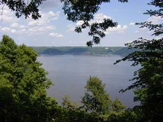
Frontenac State Park is a state park of Minnesota, United States, on the Mississippi River 10 miles (16 km) southeast of Red Wing. The park is notable both for its history and for its birdwatching opportunities. The centerpiece of the park is a 430-foot-high (130 m), 3-mile-long (4.8 km) steep limestone bluff overlooking Lake Pepin, a natural widening of the Mississippi. The bluff is variously called Garrard's Bluff or Point No-Point, the latter name coming from riverboat captains because of the optical illusion that it protruded into the Mississippi River. There is a natural limestone arch on the blufftop called In-Yan-Teopa, a Dakota name meaning "Rock With Opening". Park lands entirely surround the town of Frontenac, once a high-class resort at the end of the 19th century.

Yellowstone Lake State Park is a state park of Wisconsin, United States, featuring a 455-acre (184 ha) reservoir on a tributary of the Pecatonica River. The state park is included in the 4,047-acre (1,638 ha) Yellowstone Lake State Wildlife Area. The park has 128 campsites and 5 group sites. There is a swimming area with sand beach, picnic areas, and playgrounds. Boat launch, boat rentals, fishing for bluegill, largemouth bass, walleye and channel catfish, with some northern pike and muskellunge. Hiking trails, and groomed cross country ski trails. The adjacent 4,000 acre wildlife area offers extensive horse trails and a shooting range.

The Sand Hill River is a 101-mile-long (163 km) tributary of the Red River of the North in northwestern Minnesota in the United States. Via the Red River, Lake Winnipeg, and the Nelson River, it is part of the watershed of Hudson Bay, and drains an area of 475 square miles (1,230 km2).

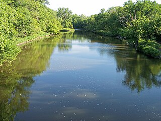
Sand Creek is a 36.6-mile-long (58.9 km) tributary of the Minnesota River in Le Sueur and Scott counties, Minnesota, United States. It rises at the outlet of Lake Sanborn, 2 miles (3 km) northeast of the city of Montgomery, and flows north past New Prague, entering the Minnesota River just north of Jordan.
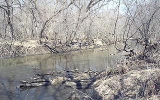
Sand Creek is a 43.3-mile-long (69.7 km) tributary of the St. Croix River in Pine County, eastern Minnesota, United States.
The Sand River is a river of Minnesota, United States. It is a tributary of the Stony River.
Pike Creek is a stream in Morrison County, in the U.S. state of Minnesota. It is a tributary of the Mississippi River.
