
St. John's is the capital and largest city of the Canadian province of Newfoundland and Labrador, located on the eastern tip of the Avalon Peninsula on the island of Newfoundland.

Prince Edward Island National Park is a National Park of Canada located in the province of Prince Edward Island. Situated along the island's north shore, fronting the Gulf of St. Lawrence, the park measures approximately 60 km (37 mi) in length and ranges from several hundred metres to several kilometres in width. Established in 1937, the park's mandate includes the protection of many broad sand beaches, sand dunes and both freshwater wetlands and saltmarshes. The park's protected beaches provide nesting habitat for the endangered piping plover; the park has been designated a Canadian Important Bird Area.
John Christopher Pratt, is a Canadian painter and printmaker.

Nunatsiavut is an autonomous area claimed by the Inuit in Newfoundland and Labrador, Canada. The settlement area includes territory in Labrador extending to the Quebec border. In 2002, the Labrador Inuit Association submitted a proposal for limited autonomy to the government of Newfoundland and Labrador. The constitution was ratified on December 1, 2005, at which time the Labrador Inuit Association ceased to exist, and the new Government of Nunatsiavut was established, initially being responsible for health, education and cultural affairs. It is also responsible for setting and conducting elections, the first of which was executed in October 2006. An election for the ordinary members of the Nunatsiavut Assembly was held on May 4, 2010. The Nunatsiavut Assembly was dissolved on April 6 in preparation for the election. Its incumbent president is Johannes Lampe who assumed office in 2016.

Prince Edward County (PEC) is a municipality in southern Ontario, Canada. Its coastline on Lake Ontario’s northeastern shore is known for Sandbanks Provincial Park, which has sandy beaches and towering limestone cliffs. The Regent Theatre, a restored Edwardian opera house, sits at the heart of the town of Picton on the Bay of Quinte. Nearby Macaulay Heritage Park highlights local history through its 19th-century buildings. In 2016, Prince Edward County had a census population of 24,735. Prince Edward County is a city, single-tier municipality and a census division of the Canadian province of Ontario.

Nain is the northernmost permanent settlement in the Canadian province of Newfoundland and Labrador, within the Nunatsiavut region, located about 370 km (230 mi) by air from Happy Valley-Goose Bay. The town was established as a Moravian mission in 1771 by Jens Haven and other missionaries. As of 2021, the population is 847 mostly Inuit and mixed Inuit-European. Nain is the administrative capital of the autonomous region of Nunatsiavut.

An outport is the term given for a small coastal community in the Canadian province of Newfoundland and Labrador other than the chief port of St. John's. Originally, the term was used for coastal communities on the island of Newfoundland, but the term has now been adopted for those on the mainland area of Labrador as well.
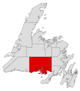
Fortune Bay—Cape La Hune is a provincial electoral district for the House of Assembly of Newfoundland and Labrador, Canada. When created in 1975 it was called Fortune-Hermitage. As of 2011, there are 6,053 eligible voters living within the district.

Burgeo-La Poile is a provincial electoral district for the House of Assembly of Newfoundland and Labrador, Canada. As of 2011, there are 7,527 eligible voters living within the district. The district was first created when Newfoundland joined confederation in 1949 as Burgeo and La Poile, and existed until 1975. It was recreated in 1995 following a reduction in the number of seats in the House of Assembly from 52 to 48, forming from the amalgamation of the former districts of La Poile and Burgeo-Bay D'Espoir.

The St. John's water dog, also known as the St. John's dog or the lesser Newfoundland, is an extinct landrace of domestic dog from Newfoundland. Little is known of the types that went into its genetic makeup, although it was probably a random-bred mix of old English, Irish and Portuguese working dogs. They were favourite dogs of fishermen because they had extraordinary qualities like good temperament and working behaviour. The number of St. John's water dogs started declining by the beginning of the 20th century. By the early 1980s, the landrace was extinct.

Sandbanks Provincial Park is a provincial park located on Lake Ontario in Prince Edward County near Picton, Ontario, Canada. The park is considered one best sandy beaches in Ontario and contains the largest bay-mouth barrier dune formation in the world. The 1,550.87-hectare (3,832.3-acre) park was established in 1970 and operates year round. Birdwatching, camping, cycling, fishing, and swimming are among the activities available in the park.
Ramea is a small village in Newfoundland and Labrador located on Northwest Island, one of a group of five major islands located off the south coast of Newfoundland, Canada. The island is approximately 3.14 km long by 0.93 km wide. The other major islands in the archipelago are Great Island, Middle Island, Harbour Island, and South West Island.

Burgeo is a town in the Canadian province of Newfoundland and Labrador. It is located mainly on Grandy Island, on the south coast of the island of Newfoundland. It is an outport community.
Bay d'Espoir is an arm of Hermitage Bay in the Gulf of Saint Lawrence, located on the south coast of Newfoundland. Communities in Bay d'Espoir include: Milltown-Head of Bay d'Espoir, Morrisville, St. Alban's, St. Joseph's Cove, St. Veronica's and Miawpukek. The Miawpukek First Nation reserve of Samiajij Miawpukek is located in Bay d'Espoir.
Route 480, also known as Burgeo Highway or The Burgeo Road, is a 150-kilometre-long (93 mi) north-south on southwestern Newfoundland in the Canadian province of Newfoundland and Labrador. It connects the town of Burgeo with the Trans-Canada Highway. The highway is a winding two-lane highway traveling through remote, hilly, and wooded terrain for its entire length. There are no other communities of any kind along the highway, with thes only other intersections being abandoned logging roads. Route 480 also provides access to Sandbanks Provincial Park and ferries to the remote outports of Ramea, Grey River and Francois at its southern terminus. There are also several vacation/hunting camps along Route 480, including Peter Strides.
Grey River is a local service district and designated place in the Canadian province of Newfoundland and Labrador. Grey River was first settled in the early 1800s by English 'youngsters' brought to Newfoundland via great merchant houses based at Ramea, Burgeo, and Gaultois. James Style(s) was the earliest known resident reported in 1835.
Francois is a local service district and designated place in the Canadian province of Newfoundland and Labrador. It is located on the southern coast of Newfoundland on François Bay at the end of a small fjord. There is a general store, a post office and a small museum, accessed by concrete pathways and boardwalks. Most residents pronounce the name "Fran-sway", and its proper spelling is without the cedilla found in the French word françois.

Andrew Parsons is a Canadian politician and lawyer, who was elected to the Newfoundland and Labrador House of Assembly in the 2011 provincial election.

A Whale for the Killing is an American television film that aired on ABC on February 1, 1981. It is loosely based on a true story by environmentalist Farley Mowat, about a whale that is tortured by a fisherman. The incident happened near Burgeo, Newfoundland, while Mowat & family lived there.

