Related Research Articles
The Tabard was an inn in Southwark established in 1307 that stood on the east side of Borough High Street, at the road's intersection with the ancient thoroughfare to Canterbury and Dover. It was built for the Abbot of Hyde, who purchased the land to construct a place for himself and his ecclesiastical brethren to stay when on business in London.
The WC postcode area, also known as the London WC postcode area, is a group of postcode districts in central London, England. The area covered is of high density development, and includes parts of the City of Westminster and the London Boroughs of Camden and Islington, plus a very small part of the City of London.
Daily Information is a printed information sheet in Oxford, England, displayed especially around the University colleges and departments, but also in local businesses. It has been in continuous existence since 28 September 1964, mostly as a brightly coloured A2 sheet, with premises originally in Warnborough Road, North Oxford. It provides information on events in and outside of Oxford, as well as reviews and small advertisements.
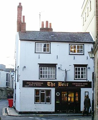
The Bear is a pub in Oxford, England, that was founded in 1774 as The Jolly Trooper. It stands on the corner of Alfred Street and Blue Boar Street, opposite Bear Lane in the centre of Oxford, just north of Christ Church, on the site of St Edward's churchyard. It was converted from the early 17th century residence of the stableman (ostler) for the coaching inn, The Bear Inn, which was on the High Street, Oxford. When The Bear Inn was converted into private housing in 1801, The Jolly Trooper changed its name to The Bear. There is a claim that by adopting its name, the current (1774) Bear Inn has acquired the history of the pub on the High Street, and so is one of the oldest pubs in Oxford. In 1952 the then landlord, Alan Course, started a collection of tie ends; a selection of the over 4,500 ties are on display around the pub. The tie collection was used as part of the plot of Colin Dexter's novel Death Is Now My Neighbour, in which Inspector Morse consults the landlord in order to identify a club tie. The building was Class II listed in January 1954.

Alfred Street is a street running between the High Street to the north and the junction with Blue Boar Street and Bear Lane at the southern end, in central Oxford, England. To the south is Christ Church, one of Oxford University's historic colleges.

Blue Boar Street is a narrow historic street running between St Aldate's to the west and the southern end of Alfred Street to the east, in central Oxford, England. It is located just north of Christ Church.

Magpie Lane is a narrow historic lane in central Oxford, England. It leads south from the High Street where it is at its narrowest, now completely pedestrianised as a pavement, and north from the cobbled Merton Street.

New Inn Hall Street is a street in central Oxford, England, and is one of Oxford's oldest streets. It is a shopping street running north–south parallel and to the west of Cornmarket Street, with George Street to the north and Bonn Square at the west end of Queen Street to the south. St Michael's Street leads off the street to the east near the northern end. Shoe Lane to the east leads to the Clarendon Centre, a modern shopping centre.

Market Street is a street in central Oxford, England, running east to west.

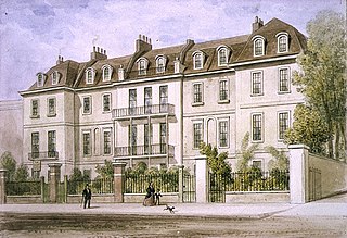
Cadogan Square is a residential square in Knightsbridge, London, that was named after Earl Cadogan. Whilst it is mainly a residential area, some of the properties are used for diplomatic and educational purposes.
Lindsey House is a Grade II* listed villa in Cheyne Walk, Chelsea, London. It is owned by the National Trust but tenanted and only open by special arrangement.
Vine Hall was an academic hall of the University of Oxford, located on Alfred Street in the 16th century. It became a part of the Peckwater Quadrangle of Christ Church, Oxford. The building gave its name to the previous name for Alfred Street, particularly the southwards continuation of it; Vine Hall Lane. Some have said that the current name Alfred Street is of unknown aetiology and pointless, and the street should be renamed Vine Hall Lane. It was previously known as St Edward's Lane, but the name Vine Hall Lane was in use by 1576.
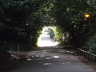
Pullens Lane is in Headington, east Oxford, England. It is located at the top of Headington Hill, leading north off Headington Road to Jack Straw's Lane and Harberton Mead. The cul-de-sac Pullens Field leads off west from Pullens Lane.

Observatory Street is a street in Oxford, England. It links at the eastern end Woodstock Road in central North Oxford and at the western end Walton Street and the Jericho area of Oxford, England.

St Bernard's Road is a residential road in North Oxford, England, connecting the southern end of Kingston Road and the northern end of Walton Street, at the junction with Walton Well Road, to the west with Woodstock Road, opposite Bevington Road, to the east.

The Bell Savage Inn was a public house in London, England, from the 15th century to 1873, originally located on the north side of what is now Ludgate Hill, in the City of London. It was a playhouse during the Elizabethan Era, as well as a venue for various other entertainments. It was also an important coaching inn. Other names by which it has been known throughout history include: Savage's Inn, The Bel Savage, Belle Savage, Belle Sauvage, Bell on the Hoop, Old Bell Savage, Belly Savage and others.

Great Clarendon Street is one of the principal thoroughfares of the Jericho district of Oxford, England, an inner suburb northwest of the centre of the city.

The Edgar Wallace is a public house at 40–41 Essex Street, London WC2, at the corner with Devereux Court.

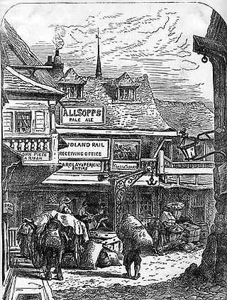
The Swan with Two Necks was a coaching inn in the City of London that, until the arrival of the railways, was one of the principal departure points for travel to the north of England from London. Its site was given over in the early 1860s to a goods and parcels depot for a firm of railway agents and carriers.
The Abingdon Arms was a public house, originally a coaching inn, in Market Street, Oxford, England.
References
- ↑ "Daily Telegraph Obituary - Christopher Lennox-Boyd" . Retrieved 29 August 2012.