Wulkuraka is a suburb of Ipswich, Queensland, Australia. At the 2016 Australian Census, it had a population of 1,234.
The City of Ipswich is a local government area in Queensland, Australia, located in the southwest of the Brisbane metropolitan area, including the urban area surrounding the city of Ipswich and surrounding rural areas. Ipswich's population is estimated to grow from the current number of 200,000 people to around 435,000 by 2031.
Queensland is the second-largest and third-most populous state in the Commonwealth of Australia. Situated in the north-east of the country, it is bordered by the Northern Territory, South Australia and New South Wales to the west, south-west and south respectively. To the east, Queensland is bordered by the Coral Sea and Pacific Ocean. To its north is the Torres Strait, with Papua New Guinea located less than 200 km across it from the mainland. The state is the world's sixth-largest sub-national entity, with an area of 1,852,642 square kilometres (715,309 sq mi).
The separate colony of Queensland was established in 1859. The few inhabitants of the new colony looked to intensify economic exploitation of the land and increase the size of the population. The building of railways was seen to facilitate both of these aims and as such was given a high priority by the new Queensland government. Consequently, the Southern and Western Railway Bill was introduced to parliament in August 1863 and the government appointed Abram Fitzgibbon, an Irish engineer with international experience in railway construction, as Chief Engineer (later Commissioner for Railways). Fitzgibbon's first task was the construction of a railway between Ipswich and Toowoomba.[1]
Ipswich is an urban region in south-east Queensland, Australia, which is located in the south-west of the Brisbane metropolitan area. Situated on the Bremer River, it is approximately 40 kilometres (25 mi) west of the Brisbane CBD. A local government area, the City of Ipswich has a population of 200,000. The city is renowned for its architectural, natural and cultural heritage. Ipswich preserves and operates from many of its historical buildings, with more than 6000 heritage-listed sites and over 500 parks. Ipswich began in 1827 as a mining settlement.
Toowoomba is a regional city in the Darling Downs region in the Australian state of Queensland. It is 125 km (78 mi) west of Queensland's capital city Brisbane by road. The estimated urban population of Toowoomba as of June 2017 was 135,631. A university and cathedral city, it hosts the Toowoomba Carnival of Flowers each September and national championship events for the sports of mountain biking and motocross. There are more than 150 public parks and gardens in Toowoomba. It has developed into a regional centre for business and government services. It is also referred to as the capital of the Darling Downs. Toowoomba is served by Toowoomba Wellcamp Airport and the smaller Toowoomba City Aerodrome.
Planning for the new railway meant serious economic and geographic challenges had to be overcome. Earlier railway construction in the southern Australian colonies was modelled on the railways of Great Britain and featured broad gauge, double track, easy grades, wide radius curves and substantial station buildings. It was quickly discovered that the construction costs for such a rail system were beyond the budget of the fledgling Queensland colonial government. The natural geography around the Darling Downs also precluded an easy grade, with any railway requiring a steep ascent of the eastern escarpment of the Great Dividing Range and the crossing of several creeks and streams.[1]
The Main Line is a railway line in South East Queensland, Australia. It was opened in a series of sections between 1865 and 1867. It commences at Roma St Station in Brisbane and extends west 161 km to Toowoomba. It is the first narrow gauge main line constructed in the world. The section of the line from the end of Murphys Creek railway station to the Ruthven Street overbridge, Harlaxton is listed on the Queensland Heritage Register. The Murphys Creek Railway Complex, the Lockyer Creek Railway Bridge (Lockyer), the Lockyer Creek Railway Bridge and Swansons Rail Bridge are also heritage listed.
The Darling Downs is a farming region on the western slopes of the Great Dividing Range in southern Queensland, Australia. The Downs are to the west of South East Queensland and are one of the major regions of Queensland. The name was generally applied to an area approximating to that of the Condamine River catchment upstream of Condamine township but is now applied to a wider region comprising the Southern Downs, Western Downs, Toowoomba and Goondiwindi local authority areas. The name Darling Downs was given in 1827 by Allan Cunningham, the first European explorer to reach the area and recognises the then Governor of New South Wales, Ralph Darling.
The Great Dividing Range, or the Eastern Highlands, is Australia's most substantial mountain range and the third longest land-based range in the world. It stretches more than 3,500 kilometres (2,175 mi) from Dauan Island off the northeastern tip of Queensland, running the entire length of the eastern coastline through New South Wales, then into Victoria and turning west, before finally fading into the central plain at the Grampians in western Victoria. The width of the range varies from about 160 km (100 mi) to over 300 km (190 mi). The Greater Blue Mountains Area, Gondwana Rainforests, and Wet Tropics of Queensland World Heritage Areas are located in the range.
Fitzgibbon proposed a radical engineering solution to these challenges through the adoption of a narrow 3 ft 6 in gauge. Standard gauge at the time was 4feet 8.5inches (1.435m) and was in itself considered narrow when compared with other broad rail gauges then in use throughout the world. By using narrow gauge, savings on construction costs could be achieved. The disadvantages of such a decision meant sharper curves on ascending ranges, lower speeds, lighter bridges and as a consequence, smaller locomotives and rolling-stock. The use of narrow gauge was largely untried anywhere else in the world, except for small-scale narrow gauge operations in New Zealand and Wales.[1]
Railways with a track gauge of 3 ft 6 in / 1,067 mm were first constructed as horse-drawn wagonways. From the mid-nineteenth century, the 3 ft 6 in gauge became widespread in the British Empire, and was adopted as a standard in Japan and Taiwan.
Substantial cost savings were also to be made through the use of standard designs for bridges, buildings, houses and yards. At this time, the quality of Queensland timber was largely unknown and little was to be used on the first railway, except for sleepers. Bridges were to be built of iron with brick and stone culverts. It was only later that Queensland became a leader in wooden bridge design, with the emergence of elaborate timber designs and later more economical timber structures.[1]
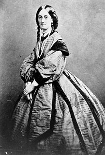
Construction of the railway was contracted to Peto, Brassey & Betts, a firm with considerable railway construction experience worldwide. A fixed sum contract was negotiated for the construction of the first line between Ipswich and Bigges Camp (today's Grandchester), with a follow on contract for four other sections of line between Bigges Camp and Toowoomba. Lady Diamantina Bowen, wife of the first Governor of Queensland, turned the first sod of earth for the first section of railway on 25 February 1864.[1]
Grandchester is a town in the Lockyer Valley region in South East Queensland, Australia. It is located 76 kilometres (47 mi) west of the Brisbane CBD and is within the boundaries of the City of Ipswich. The name derives from the old English name for bigge (Grand) and camp (Chester), which was the initial name of the locality, and suggested by the wife of the Governor of the day when the railway opened. At the 2011 census, Grandchester had a population of 504.
Diamantina, Lady Bowen was a noble from the formerly Venetian Ionian Islands who became the wife of Sir George Bowen, the first Governor of Queensland.
The Governor of Queensland is the representative in the state of Queensland of the Queen of Australia. In an analogous way to the Governor-General of Australia at the national level, the Governor performs constitutional and ceremonial functions at the state level. In particular the governor has the power to appoint and dismiss the Premier of Queensland and all other ministers in the cabinet, and issue writs for the election of the state parliament.
The first consignment of construction materials arrived in Ipswich by steamer on 15 August 1864. An initial line was laid down to the wharf in Ipswich to receive consignments of materials and move them to a workshops site on level ground above. Public pressure for a bridge across the river resulted in a change of plan and the terminus was moved to South Ipswich in the business centre. A bridge was constructed to carry both road and rail and was just completed in time for the opening of the first section of rail to Grandchester.[1]
The first trial run along the line with a train was on 13 April 1865. The first section of line between Ipswich and Bigges Camp (a distance of twenty-one miles) was officially opened to traffic to great public fanfare on 31 July 1865. The line ran from the Bremer Bridge and passed the original workshops and running sheds (North Ipswich Railway Workshops) to the west and crossed Wide Gully. Extensions to the line were later made to Toowoomba (1867), Dalby (1868) and Warwick (1871).[1]
The building of the Sadliers Crossing Railway Bridge and deviation, which opened in 1875, made the old line via Mihi Creek redundant and it fell out of use except for a short section to the Ipswich workshops and to service a coalmine. The line was officially closed on 26 April 1875.[1]
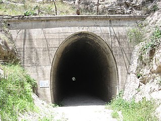
Queensland Railways demonstrated the viability of the use of narrow gauge, thereby influencing other countries including Japan, Africa and New Zealand to also adopt the technology. The construction of the Ipswich to Bigges Camp railway, of which the Sandstone Railway Culvert at Wulkuraka is a part, set the precedent for the construction and design of the many lightly constructed and sinuous narrow gauge railways that have since been built around the world.[1]
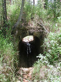
Description
The original line to Bigges Camp ran via North Ipswich roughly following the north bank of the Bremer River before crossing Mihi Creek and turning southwest towards today's Wulkuraka. The original line beyond Wulkuraka is still in use, although it has been duplicated, realigned and re-graded.[1]
The sandstone culvert, a small brick-lined drain and the remains of railway line embankments are all found on the bushland reserve. The remains of the embankments begin in the northeastern corner of the property and end just short of the southern property boundary.[1]
The sandstone culvert is situated in the northeastern corner of the reserve close to the property boundary. The area immediately adjacent to the culvert contains a number of trees of varying ages, and is thickly covered in tall grass and other scrub. The culvert measures approximately 2 metres (6ft 7in) in width and 2.5 metres (8ft 2in) in height. The length of the culvert from the southeastern entrance to the remains of the northwestern end is 16 metres (52ft).[1]
The base and lower half of the culvert is constructed of poor quality grayish sandstone to a height of approximately 1 metre (3ft 3in). These sandstone blocks are heavily weathered as a result of water erosion. The curved roof is made of fired red bricks built in two overlapping layers. Both the sandstone and upper brick structures feature lime mortar, which is in poor condition and is crumbling.[1]
The southeastern end of the culvert remains intact. Inside the culvert, the middle section is largely intact though a small amount of graffiti is present on the upper brick walls. The northwestern end has disintegrated badly. At a point 10–12 metres (33–39ft) from the Southeastern end, the lower sandstone and upper brick sections have collapsed and been washed away. Some of the scattered sandstone blocks have been pecked, suggesting that this side of the culvert was dressed for aesthetic purposes.[1]
A small brick-lined drain is located along the railway line embankment to the southwest of the culvert. This drain is made from the same red bricks as found in the larger culvert. It is difficult to determine the overall condition of the drain as it is heavily silted up, though what is visible is in an average condition.[1]
Significant physical elements of the place include:[1]
The complex created by the presence of the culvert, the remaining railway line embankments and the small brick-lined drain
The sandstone used in the culvert, which is contemporary and probably from the same source as that used in the abutments found in the Heiner Road Railway Overpass
Heritage listing
Sandstone Railway Culvert and Remains was listed on the Queensland Heritage Register on 24 June 2005 having satisfied the following criteria.[1]
The place is important in demonstrating the evolution or pattern of Queensland's history.
The Sandstone Railway Culvert and Remains at Wulkuraka are important in demonstrating the pattern of Queensland's history as a product of the first main line railway constructed in Queensland. It illustrates the unique development of the Queensland railway network and provides tangible evidence of the geographic, demographic and economic development of the fledgling Queensland colony in the 1860s.[1]
The place demonstrates rare, uncommon or endangered aspects of Queensland's cultural heritage.
As physical evidence of Queensland's first railway, the place is an uncommon and endangered part of Queensland's cultural heritage. The sandstone culvert was constructed in 1864–65 and is contemporary to the abutments of the Heiner Road railway overbridge (Heiner Road Railway Overpass), making it one of the few surviving remnants of the first railway ever to be constructed in Queensland. The Sandstone Railway Culvert and Remains at Wulkuraka are also significant as uncommon and endangered elements of the oldest surviving 3feet 6inches (1.07m) railway found anywhere in the world.[1]
The place has a special association with the life or work of a particular person, group or organisation of importance in Queensland's history.
The place has a special association with Abram Fitzgibbon, who made an important contribution as Queensland's first Commissioner for Railways and initiator of narrow gauge rail in Queensland. Fitzgibbon's use of narrow gauge revolutionized railway design in Queensland, Australia and throughout the world. Fitzgibbon also brought with him a number of well-qualified railway engineers, providing valuable expertise in railway construction and design, thereby shaping the development of the modern Queensland rail network.[1]
Related Research Articles
The Ipswich and Rosewood line refers to the section of the Main Line to Toowoomba that has a regular suburban rail service, extending southwest from the Brisbane central business district. It is part of the Queensland Rail City network.
Australians generally assumed in the 1850s that railways would be built by the private sector. Private companies built railways in the then colonies of Victoria, opened in 1854, and New South Wales, where the company was taken over by the government before completion in 1855, due to bankruptcy. South Australia's railways were government owned from the beginning, including a horse-drawn line opened in 1854 and a steam-powered line opened in 1856. In Victoria, the private railways were soon found not to be financially viable, and existing rail networks and their expansion was taken over by the colony. Government ownership also enabled railways to be built to promote development, even if not apparently viable in strictly financial terms. The railway systems spread from the colonial capitals, except in cases where geography dictated a choice of an alternate port.
Wulkuraka railway station is located on the Main line in Queensland, Australia. It serves the Ipswich suburb of Wulkuraka.
The Queensland rail network, the first in the world to adopt 1,067 mm narrow gauge for a main line, and now the second largest narrow gauge network in the world, consists of:
North Ipswich is a suburb of Ipswich, Queensland, Australia. At the 2011 census the suburb recorded a population of 4,587.
The Brisbane Valley railway line was a railway connection in Queensland, Australia connecting Ipswich, west of Brisbane, to the upper Brisbane River valley. Progressively opened between 1884 and 1913 the railway provided a vital transport link between Ipswich and Yarraman and forged development and prosperity along its path. The line acquired its serpentine reputation because it did not take a straight course when faced with a hill or gully.
Muntapa Tunnel is a heritage-listed tunnel from Narko-Nutgrove Road, Highgrove through to Nutgrove, both in the Toowoomba Region, Queensland, Australia. It was designed by Queensland Railways and built from 1910 to 1913 by Queensland Railways. It was added to the Queensland Heritage Register on 3 May 2007.
Main Range Railway is a heritage-listed railway from the end of Murphys Creek railway station, Murphys Creek to the Ruthven Street overbridge, Harlaxton, Queensland, Australia. It forms part of the Main Line railway and was built from 1865 to 1867 by railway builders Peto, Brassey and Betts. It was added to the Queensland Heritage Register on 5 February 2009.
Sadliers Crossing Railway Bridge is a heritage-listed railway bridge at over Bremer River between Tallon Street, Sadliers Crossing and Dixon Street, Wulkuraka, Queensland, Australia on the Main Line (this section is now the Ipswich and Rosewood railway line. It was added to the Queensland Heritage Register on 13 November 2008.
Wallangarra railway station is a heritage-listed railway station at Woodlawn Street, Wallangarra, Southern Downs Region, Queensland, Australia. It was built in 1877 along the state border of Queensland and New South Wales It was added to the Queensland Heritage Register on 28 March 2003.
Bremer River Rail Bridge is a heritage-listed railway bridge at off Bremer Street, North Ipswich, City of Ipswich, Queensland, Australia. It was built from 1865 to 1915. It was added to the Queensland Heritage Register on 11 December 2006.
Heiner Road Railway Overpass is a heritage-listed road bridge within the Riverlink Shopping Centre at 2 Downs Street, North Ipswich, City of Ipswich, Queensland, Australia. It was built in 1865. It was added to the Queensland Heritage Register on 28 May 2004.
The Mihi Creek heritage site is a heritage-listed archaeological site at Mihi Junction, Brassall, City of Ipswich, Queensland, Australia. It is also known as Mihi Junction and Mi Hi Creek. It was added to the Queensland Heritage Register on 16 July 2010.
Sandstone Railway Culvert is a heritage-listed culvert at about 130 metres (430 ft) west of the corner of WM Hughes Street and Musgrave Street, North Ipswich, City of Ipswich, Queensland, Australia. It was built between 1864 and 1865. It was added to the Queensland Heritage Register on 13 November 2008.
Harlin Rail Bridge is a heritage-listed railway bridge over Ivory Creek at Harlin, Somerset Region, Queensland, Australia. It was designed by Queensland Railways and built in 1910 by Queensland Railways. It was added to the Queensland Heritage Register on 27 November 2008. It was destroyed in 2013 as a consequence of flooding associated with Cyclone Oswald.
Yimbun Railway Tunnel is a heritage-listed tunnel at Sinnamons Lane, Harlin, Somerset Region, Queensland, Australia. It was designed by Queensland Railways and built from 1909 to 1910 by Queensland Railways. It was added to the Queensland Heritage Register on 27 November 2008.
Alexandra Railway Bridge is a heritage-listed railway bridge adjacent to North Street, Rockhampton, Rockhampton Region, Queensland, Australia. It was designed by Henry Charles Stanley and built from 1898 to 1899 by George Charles Willcocks. It was added to the Queensland Heritage Register on 21 October 1992.
Ipswich North State School is a heritage-listed state school at 9 Fitzgibbon Street, North Ipswich, City of Ipswich, Queensland, Australia. It was designed by Frederick Thomas Jellet and built from 1934 to 1937 by Queensland Department of Public Works. It was formerly known as North Ipswich National School. It was added to the Queensland Heritage Register on 5 February 2016.
This page is based on this Wikipedia article Text is available under the CC BY-SA 4.0 license; additional terms may apply. Images, videos and audio are available under their respective licenses.