Sandwich Toll Bridge

Last updated

View from the east in 2019 Sandwich swing bridge (geograph 6028793).jpg
View from the east in 2019

Sandwich Toll Bridge is a Grade II listed road swing bridge over the River Stour in Sandwich, Kent. It opened in 1755 on a site that had been a crossing for centuries, and has had several iterations; the current is a swing bridge that opened in 1892. Tolls were abolished in 1977.

Contents

The bridge has been part of the A256 road, a major route across east Kent. This became a significant traffic bottleneck, until a bypass opened in 1981.

History

Early history

View of the toll gate towards the town Toll gate, Sandwich - geograph.org.uk - 955735.jpg
View of the toll gate towards the town

A plaque on the bridge indicates there has been a tolled crossing, originally a ferry, in this rough location since 1127. [1] The crossing forms part of a former turnpike road from Sandwich to the Isle of Thanet that has existed since the late 14th century. [2] A customs house was built at the southern edge of the crossing during Edward IV's reign. [3] The ferry route was frequently dangerous and difficult, and the Mayor of Sandwich petitioned Parliament to have a permanent bridge installed. [4]

Sandwich Bridge Act 1755
Act of Parliament
Coat of Arms of Great Britain (1714-1801).svg
Long title An Act for building a Bridge over the Water, or Haven, between the Town of Sandwich and the opposite Shore in the County of Kent.
Citation 28 Geo. 2. c. 55
Dates
Royal assent 25 April 1755

The original bridge was authorised by the Sandwich Bridge Act 1755 and opened that year. [3] The total cost was £1,000, of which £600 was publicly funded with the remainder coming from the Corporation of Sandwich. [4] It was rebuilt in 1773 from Portland Stone with a timber raised platform. [5] [6] A table of tolls is displayed on the side of the adjacent Barbican Gate to the south. [2] A new wooden bridge was constructed in 1856, followed by a three-arch iron swing bridge in 1892, to allow river traffic to pass through. [4] [5] [7] The reconstruction supported stone arches at the north and south ends. [5] The bridge supports the town's coat of arms on its side. [8]

Modern history

The bridge holds a crest of the town's coat of arms Sandwich, town bridge (detail) - geograph.org.uk - 650895.jpg
The bridge holds a crest of the town's coat of arms

The bridge formed part of the original route of the A256, a major road along the East Kent coast from Dover to Thanet. In 1962, the toll was 1 shilling (5p) for cars and 1/3 (6¼p) - 1/6 (7½p) for goods vehicles. [9] By 1965, it had become a significant bottleneck on the A256 as it could only carry a single lane of motor traffic and was the only crossing of the Stour in the local area. [10] A petition for a bypass was signed by 3,000 residents. [11] In 1973, a fund was set up to use excess monies from tolls to pay for local infrastructure. [12]

The bridge was Grade II listed in 1976. [5] Tolls were abolished the following year, with the final one being collected by the Mayor Councillor on 30 September. [2] [1] A bypass of Sandwich opened in 1981, taking traffic away from the bridge, yet it continued to attract congestion as it was used as a rat run. [13]

In 2018, the bridge began to suffer reliability problems. [14] While Kent County Council were investigating repairs, on 9 June 2019, the bridge was stuck open after shipping vessel passed through. Following emergency work, it reopened on 24 June. [15] The bridge was expected to close again in February 2020 to all traffic, including pedestrians, but this was postponed. [16] [17] The repairs eventually began in September 2020, closing the bridge for 11 weeks, costing the council half a million pounds. Further maintenance, installing a bespoke gearbox on the bridge, continued the following year. [18]

Related Research Articles

<span class="mw-page-title-main">Dartford Crossing</span> Tunnel and bridge between Kent and Essex, UK

The Dartford-Thurrock River Crossing, commonly known as the Dartford Crossing and until 1991 the Dartford Tunnel, is a major road crossing of the River Thames in England, carrying the A282 road between Dartford in Kent in the south and Thurrock in Essex in the north.

<span class="mw-page-title-main">Sandwich, Kent</span> Town in Kent, England

Sandwich is a town and civil parish in the Dover District of Kent, south-east England. It lies on the River Stour and has a population of 4,985. Sandwich was one of the Cinque Ports and still has many original medieval buildings, including several listed public houses and gates in the old town walls, churches, almshouses and the White Mill. While once a major port, it is now 2 miles (3 km) from the sea due to the disappearance of the Wantsum Channel. Its historic centre has been preserved. Sandwich Bay is home to nature reserves and two world-class golf courses, Royal St George's and Prince's. The town is also home to many educational and cultural events. Sandwich also gave its name to the food by way of John Montagu, 4th Earl of Sandwich, and the word sandwich is now found in several languages.

<span class="mw-page-title-main">Tamar Bridge</span> Suspension bridge in southwest England

The Tamar Bridge is a suspension bridge over the River Tamar between Saltash, Cornwall and Plymouth, Devon in southwest England. It is 335 metres (1,099 ft) long, running adjacent the Royal Albert Bridge, and part of the A38, a main road between the two counties.

<span class="mw-page-title-main">River Stour, Kent</span> River in England

The River Stour(, rhymes with "flour") is a river in Kent, England that flows into the North Sea at Pegwell Bay. Above Plucks Gutter, where the Little Stour joins it, the river is normally known as the Great Stour. The upper section of the river, above its confluence with the East Stour at Ashford is sometimes known as the Upper Great Stour or West Stour. In the tidal lower reaches, the artificial Stonar Cut short cuts a large loop in the natural river.

<span class="mw-page-title-main">Isle of Thanet</span> Peninsula in Kent, England

The Isle of Thanet is a peninsula forming the easternmost part of Kent, England. While in the past it was separated from the mainland by the 600-metre-wide (2,000 ft) Wantsum Channel, it is no longer an island.

<span class="mw-page-title-main">Blackwall Tunnel</span> Pair of road tunnels underneath the River Thames in London

The Blackwall Tunnel is a pair of road tunnels underneath the River Thames in east London, England, linking the London Borough of Tower Hamlets with the Royal Borough of Greenwich, and part of the A102 road. The northern portal lies just south of the East India Dock Road (A13) in Blackwall; the southern entrances are just south of The O2 on the Greenwich Peninsula. The road is managed by Transport for London (TfL).

<span class="mw-page-title-main">A38 road</span> Trunk road in England

The A38, parts of which are known as Devon Expressway, Bristol Road and Gloucester Road, is a major A-class trunk road in England.

<span class="mw-page-title-main">M20 motorway</span> Motorway in Kent, England

The M20 is a motorway in Kent, England. It follows on from the A20 at Swanley, meeting the M25, and continuing on to Folkestone, providing a link to the Channel Tunnel and the ports at Dover. It is 50.6 miles (81.4 km) long. Although not signposted in England, this road is part of the European route E15. It is also used as a holding area for goods traffic when traffic across the English Channel is disrupted, such as Operation Stack and Operation Brock.

<span class="mw-page-title-main">Dover District</span> Non-metropolitan district in England

Dover is a local government district in Kent, England. It is named after its largest town, the port town of Dover. The council is based in Whitfield on the outskirts of Dover. The district also covers the towns of Deal, Sandwich, Walmer and the surrounding rural areas.

<span class="mw-page-title-main">Sandwich Bay, Kent</span> Inlet in Sandwich, Kent, England

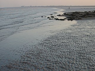
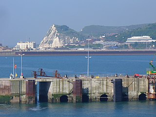
Sandwich Bay is a long sweeping inlet of the sea between Ramsgate and Deal, on the east coast of Kent, England. The coastal area consists of sand flats with their associated salt marshes and coastal sand dunes. The Sandwich Flats stretch for about five miles (8 km) along the coast. The coastal habitats are of high ecological importance.

<span class="mw-page-title-main">A299 road</span> Road on the northern coast of Kent

The A299, better known as the Thanet Way, is a major road of 22 miles (35 km) in the county of Kent, England, and runs from Brenley Corner near Faversham to Ramsgate via Whitstable and Herne Bay.

<span class="mw-page-title-main">Ashford–Ramsgate line</span>

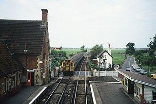
The Ashford–Ramsgate line is a railway that runs through Kent from Ashford to Ramsgate via Canterbury West. Its route mostly follows the course of the River Great Stour.

<span class="mw-page-title-main">A256 road</span> Road in Kent

The A256 is a major road running along the east coast of Kent between the Isle of Thanet and Dover. It is operated by Kent County Council as a primary route, and has seen investment in the past to connect traffic to the Port of Ramsgate, and to the Pfizer research centre in Sandwich.

<span class="mw-page-title-main">A477 road</span> Road in the United Kingdom

The A477 is a major road in South Pembrokeshire and Carmarthenshire connecting St Clears and Johnston. Its route includes the Cleddau Bridge, a former toll bridge linking Pembroke Dock and Neyland.

<span class="mw-page-title-main">Cliffsend</span> Human settlement in England

Cliffsend is a village and civil parish situated almost 2 miles (3 km) west of Ramsgate, Kent, United Kingdom, in the Thanet local government district.

Richboro Port railway station was constructed by the East Kent Light Railway, as part of its branch to Richborough Port, which never opened to passengers. Authorisation to operate a passenger service over the branch was never requested by the East Kent as it considered that the Port had first to develop before expenses could be outlaid on improving the branch's bridges over the Southern Railway and River Stour, which His Majesty's Railway Inspectorate would no doubt have required before giving its consent. The station was named Richboro Port, dropping the "ugh" off the end of Richborough, as witnessed by the nameboard on the station and contemporary maps.

<span class="mw-page-title-main">Shoreham Tollbridge</span> Bridge in Shoreham and Lancing, West Sussex

Shoreham Tollbridge is a bridge crossing the River Adur in West Sussex, England. It is the last of its kind in Sussex and one of the last of its kind anywhere in the world.

<span class="mw-page-title-main">Barton Road Swing Bridge</span> Bridge for road traffic in Greater Manchester, England

Barton Road Swing Bridge is a swing bridge for road traffic in Greater Manchester that crosses the Manchester Ship Canal between Trafford Park in the Metropolitan Borough of Trafford to Barton-upon-Irwell in the City of Salford. The bridge is a Grade II listed building, and is part of a surrounding conservation area. It runs parallel to the Barton Swing Aqueduct which carries the Bridgewater Canal. The bridge opens regularly for traffic along the Manchester Ship Canal, which can cause delays for road traffic.

<span class="mw-page-title-main">Lord of the Manor, Kent</span>

The Lord of the Manor is a former pub and road junction near Cliffsend on the Isle of Thanet in Kent. Two main roads, the A299 and A256 meet here and connect Thanet to the rest of the country.

<span class="mw-page-title-main">Selby toll bridge</span> Bridge in North Yorkshire, England

Selby Toll Bridge is one of three swing bridges in the town of Selby, North Yorkshire, England. A timber bridge over the River Ouse in the town was opened in c. 1793 to replace a ferry crossing that had existed since Medieval times. The bridge provided a connection between the West and East Ridings of Yorkshire across the River Ouse, and became the furthest downstream public bridge crossing over the river until 1929, when the Boothferry Bridge was built. The moving section of the original bridge used ball-bearings and cog wheels; the bridge is believed to be the first in the world to use ball-bearings. The replacement 1970s bridge, now only carries the A19 road as the A63 bypass was opened in 2004.

References

  1. 1 2 "Plaque on Sandwich Toll Bridge" . Retrieved 10 February 2020.
  2. 1 2 3 Heritage Strategy Appendix 1 : Historic Roads, Routes and Lanes (PDF). Dover Borough Council (Report). p. 13. Retrieved 10 February 2020.
  3. 1 2 Hasted, Edward (1800). The town and port of Sandwich. pp. 152–216. Retrieved 10 February 2020.{{cite book}}: |work= ignored (help)
  4. 1 2 3 "Pictures of Sandwich Toll Bridge through the years as town prepares for reopening after 11 week closure". Kent Online. 17 November 2020. Retrieved 24 October 2021.
  5. 1 2 3 4 Historic England. "Details from listed building database (1343735)". National Heritage List for England . Retrieved 10 February 2020.
  6. "Tools". Hansard. 9 December 1968. Retrieved 10 February 2020.
  7. Preston, James (2017). Kent's Transport Heritage. Amberley. p. 33. ISBN   978-1-445-66992-2.
  8. "Smart new bridge reinstated over River Stour". Kent Online. 24 November 2020. Retrieved 26 October 2021.
  9. "Toll Bridges and Roads". Hansard. 23 February 1962. Retrieved 10 February 2020.
  10. "Traffic Congestions (South East Kent)". Hansard. 3 December 1965. Retrieved 10 February 2020.
  11. "Sandwich Bypass". Hansard. 19 May 1965. Retrieved 26 October 2021.
  12. "Sandwich Toll Bridge Fund". Sandwich Town Council. Retrieved 24 October 2021.
  13. Sandwich Green Paper (PDF). Faversham Town Council (Report). June 2015. p. 4. Retrieved 10 February 2020.
  14. "Removal of Sandwich Tollbridge over River Stour could spell disaster over the summer". Kent Online. 2 May 2019. Retrieved 10 February 2020.
  15. "This is when Sandwich Tollbridge will reopen - but more work is still required". Kent News. 24 June 2019. Retrieved 10 February 2020.
  16. "Sandwich Toll Bridge (Prohibition of Driving) Temporary Order 2020". Kent County Council. Retrieved 10 February 2020.
  17. "Sandwich Toll Bridge works postponed due to A256 pipe issues". Kent Online. 12 February 2020. Retrieved 24 February 2020.
  18. "Sandwich Toll Bridge to close for installation of bespoke gearbox part after 11 week closure in September". Kent Online. 21 January 2021. Retrieved 22 October 2021.

51°16′33″N1°20′32″E / 51.27595°N 1.34209°E / 51.27595; 1.34209