
Sierra Leone is located on the west coast of Africa, between the 7th and 10th parallels north of the equator. Sierra Leone is bordered by Guinea to the north and northeast, Liberia to the south and southeast, and the Atlantic Ocean to the west.

The Loma Mountains are the highest mountain range in Sierra Leone. The highest peak is Mount Bintumani which rises to a height of 1,945 metres (6,381 ft). The area has been designated a non-hunting forest reserve since 1952. The reserve covers an area of 33,201 hectares.

The Sierra Nevada de Santa Marta is an isolated mountain range separated from the Andes chain that runs through Colombia. Reaching an altitude of 5,700 m (18,700 ft) just 42 km (26 mi) from the Caribbean coast, the Sierra Nevada is one of the world's highest coastal ranges, being 250m shorter than the Saint Elias Mountains in Canada. The Sierra Nevada encompasses about 17,000 km2 (6,600 sq mi) and serves as the source of 36 rivers. The range is in the Departments of Magdalena, Cesar and La Guajira.

The Rokel River is the largest river in the Republic of Sierra Leone in West Africa. The river basin measures 10,622 square kilometres (4,101 sq mi) in size, with the drainage divided by the Gbengbe and Kabala hills and the Sula Mountains. The estuary which extends over an area of 2,950 square kilometres (1,140 sq mi) became a Ramsar wetland site of importance in 1999.
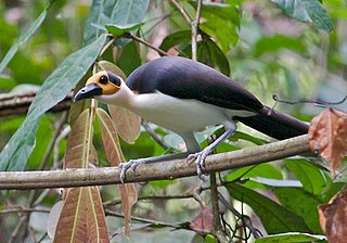
The white-necked rockfowl is a medium-sized bird in the family Picathartidae, with a long neck and tail. Also known as the white-necked picathartes, this passerine is mainly found in rocky forested areas at higher altitudes in West Africa from Guinea to Ghana. Its distribution is patchy, with populations often being isolated from each other. The rockfowl typically chooses to live near streams and inselbergs. It has no recognized subspecies, though some believe that it forms a superspecies with the grey-necked rockfowl. The white-necked rockfowl has greyish-black upperparts and white underparts. Its unusually long, dark brown tail is used for balance, and its thighs are muscular. The head is nearly featherless, with the exposed skin being bright yellow except for two large, circular black patches located just behind the eyes. Though the bird is usually silent, some calls are known.

The Protected areas of Tamil Nadu State in South India cover an area of 3,305 km2 (1,276 sq mi), constituting 2.54% of the geographic area and 15% of the 22,643 km2 (8,743 sq mi) recorded forest area. It ranks 14th among all the States and Union Territories of India in terms of total protected area.
Tiwai Island is a wildlife sanctuary and tourist site in Sierra Leone. Run by the non-governmental organization Environmental Foundation for Africa, Tiwai is 12 square kilometers in area and located on the Moa River in the Southern Province. It is also one of the largest inland islands in the country.
Amietophrynus cristiglans is a species of toad in the family Bufonidae. It is known commonly as the Tingi Hills toad and is endemic to the Tingi Hills of Sierra Leone. This species' taxonomic status remains uncertain and was considered to be a synonym of A. latifrons by Tandy and Keith (1972). It may not be a valid species.

Sierra del Rosario is a mountain range in the provinces of Pinar del Río and Artemisa, western Cuba. It is located in the eastern part of the Guaniguanico range and, along with the Sierra de los Órganos, is part of it.
Western Area Forest Reserve, also known as the Western Area Peninsula Forest Reserve, is a non-hunting forest reserve in Sierra Leone. The area became a forest reserve in 1916 and has an area of 17,688 hectares (68.29 sq mi). It was demarcated by Charles Lane Poole, Sierra Leone's first ever 'Conservator of Forests,' and founder of the Sierra Leonean Forestry Department. It is the westernmost semi-deciduous closed canopy forest in Sierra Leone. The forest is home to various endangered species, including a wide variety of endangered birds and Duiker.
Kangari Hills Forest Reserve is a non-hunting forest reserve in the centre of Sierra Leone. The area became a forest reserve in 1924. Lying between 200 and 500 metres above sea level, the reserve has an area of 8,573 hectares (85.73 km²), although parts of it area have been encroached upon by farming and mining. The Reserve is one of the few places in Sierra Leone where the endangered forest elephant survives.
Farangbaia Forest Reserve is a forest reserve with a rainforest ecosystem in Sierra Leone. The Reserve covers an area of 1,260 hectares, is located approximately 10 km to the south-east of the town of Bumbuna and forms part of the catchment area for the Seli River. Since the outbreak of Sierra Leone civil war in 1991 much of the reserve has become farmland and bush forest and there a number sawmills operating there.
The Kambui Hills Forest Reserve occupies an area of 14,335 hectares in the Eastern Province of Sierra Leone. It is located 10 kilometres from the town of Kenema with terrain consisting of steep slopes that reach an altitude of between 100 and 645 metres. The area mainly contains forest habitat but there is also some savanna and wetland. Over 200 separate species of birds have been recorded in the reserve including vulnerable species the white-necked picathartes and green-tailed bristlebill and near threatened species the yellow-casqued hornbill, rufous-winged illadopsis and copper-tailed glossy-starling.
The Tingi Hills Forest Reserve is located in a mountain range in the east of Sierra Leone and occupies an area of 118.85 km2 (45.89 sq mi). It became a forest reserve in 1947 and a non-hunting forest reserve in 1973. The area reaches from an altitude of 400 to 1850 metres at the north peak of the dual peaked Sankan Biriwa massif. In the lower regions the area consists of forest interspersed with savannah then moves into shrub savannah and then mountain grassland at higher altitudes. Over 200 species of birds have been recorded in the area and the reserve is also home to western baboons and forest elephants.
The Gola Rainforest National Park (GRNP) was declared by President of Sierra Leone Ernest Bai Koroma and enacted by the Parliament of Sierra Leone in December 2010. The park amalgamates Gola North Forest Reserve, Gola East Forest Reserve and Gola West Forest Reserves, and is Sierra Leone's second national park.
Kasewe Forest Reserve is an area of hills in the Moyamba District of Sierra Leone. It is designated as a forest reserve and contains moist semi-deciduous and evergreen forests that cover an area of 1.224 km². Made up of volcanic rock the hills stand about 500m above the interior plains of the country. The nearest town is Lunsar.
The Sankan Biriwa No or Non - Hunting Forest Reserve is found in Sierra Leone. It was established in 1947. This site is 118km².

Lake Sonfon, also known as Lake Confon, is a fresh water mountain lake in Diang, Sierra Leone of religious and cultural significance. The nearest towns are Kabala that is 60 km to the north and Benugu that is 40 km to the south. It is located in the hills of the Sula Mountains at an altitude of 549 m (1,801 ft) above sea level. Sonfon drains from its southern end, which forms the start of the Pampana River, and is fed by seven small streams with its water level varying considerably during the year. The Lake has a maximum depth of 8 m (26 ft) and with an area of 8.2 km2 (3.2 sq mi) is Sierra Leone's largest inland lake.

The Guinean montane forests are a tropical moist broadleaf forest ecoregion of West Africa

