
The Sankey brick was the preferred construction material of the South Side Flats in Pittsburgh. It was the original product of the Sankey Brick Company, founded in 1861 by William, John, and Thomas Sankey. [1]
The Sankey brick was the preferred construction material of the South Side Flats in Pittsburgh. It was the original product of the Sankey Brick Company, founded in 1861 by William, John, and Thomas Sankey. [1]
The original brick works stood at the end of a railroad at 21st Street, and now forms part of the present South Side Park. [2]
The Sankey Brothers were pioneers in the automated production of brick, using local shale instead of clay as the basis of the brick. The company had an office at 2112 Carson Street, and additional plants at 37th and Liberty in Lawrenceville and at Penn and Atlantic in the East End of Pittsburgh.
Pittsburgh is a city in the Commonwealth of Pennsylvania and the county seat of Allegheny County. It is the second-most populous city in Pennsylvania after Philadelphia and the 68th-most populous city in the U.S., with a population of 302,971 as of the 2020 census. The city anchors the Pittsburgh metropolitan area of Western Pennsylvania. Its population of 2.457 million is the largest in both the Ohio Valley and Appalachia, the second-largest in Pennsylvania, the 7th-largest in the Mid-Atlantic region and the 26th-largest in the U.S. Pittsburgh is the principal city of the greater Pittsburgh–Weirton–Steubenville combined statistical area which includes parts of Ohio and West Virginia.
Homestead is a borough in Allegheny County, Pennsylvania, United States, along the Monongahela River 7 miles (11 km) southeast of downtown Pittsburgh. The borough is known for the Homestead strike of 1892, an important event in the history of labor relations in the United States. The population was 2,884 at the 2020 census. It is part of the Pittsburgh metropolitan area.

Downtown Pittsburgh, colloquially referred to as the Golden Triangle, and officially the Central Business District, is the urban downtown center of Pittsburgh, Pennsylvania, United States. It is located at the confluence of the Allegheny River and the Monongahela River whose joining forms the Ohio River. The triangle is bounded by the two rivers.

Union Station, also known as Pennsylvania Station and commonly called Penn Station, is a historic train station in Downtown Pittsburgh, Pennsylvania. It was one of several passenger rail stations that served Pittsburgh during the 20th century; others included the Pittsburgh & Lake Erie Railroad Station, the Baltimore and Ohio Station, and Wabash Pittsburgh Terminal, and it is the only surviving station in active use.
The Pittsburgh and Lake Erie Railroad, also known as the "Little Giant", was formed on May 11, 1875. Company headquarters were located in Pittsburgh, Pennsylvania. The line connected Pittsburgh in the east with Youngstown, Ohio, in the Haselton neighborhood in the west and Connellsville, Pennsylvania, to the east. It did not reach Lake Erie until the formation of Conrail in 1976. The P&LE was known as the "Little Giant" since the tonnage that it moved was out of proportion to its route mileage. While it operated around one tenth of one percent of the nation's railroad miles, it hauled around one percent of its tonnage. This was largely because the P&LE served the steel mills of the greater Pittsburgh area, which consumed and shipped vast amounts of materials. It was a specialized railroad, deriving much of its revenue from coal, coke, iron ore, limestone, and steel. The eventual closure of the steel mills led to the end of the P&LE as an independent line in 1992.
Allegheny County Airport is in West Mifflin, Pennsylvania, United States, 7 miles (11 km) southeast of Pittsburgh. It is the fifth-busiest airport in Pennsylvania following Philadelphia, Pittsburgh, Allentown, and Harrisburg. The airport is owned by the Allegheny County Airport Authority and is the primary FAA-designated reliever airport for Pittsburgh International Airport. Allegheny County Airport was dedicated on September 11, 1931.

Uptown or The Bluff is a neighborhood in the city of Pittsburgh, Pennsylvania to the southeast of the city's Central Business District. It is bordered in the north by the Hill District and located across the Monongahela River from South Side. The predominant area zip code is 15219.

The Jones and Laughlin Steel Corporation, also known as J&L Steel or simply as J&L, was an American steel and iron manufacturer that operated from 1852 until 1968. Beginning as the American Iron Company, founded in 1852 by Bernard Lauth and Benjamin Franklin Jones, a few miles south of Pittsburgh along the Monongahela River. Lauth's interest was bought in 1854 by James Laughlin. The first firm to bear the name of Jones and Laughlin was organized in 1861, and headquartered at Third & Ross in downtown Pittsburgh.

The South Side Flats is a neighborhood in Pittsburgh, Pennsylvania's South Side area. It is located just south of the Monongahela River. The neighborhood has one of the City of Pittsburgh's largest concentrations of 19th-century homes, which has prompted outsiders to call the neighborhood the City's Georgetown. It includes many bars and restaurants as well as residences. The main throughway in the South Side Flats is East Carson Street. The street is home to a significant portion of Pittsburgh's nightlife.

Troy Hill is a neighborhood on Pittsburgh, Pennsylvania's North Side. It has a zip code of 15212, and has representation on Pittsburgh City Council by the council member for District 1.

The South Tenth Street Bridge, most often called the Tenth Street Bridge, but officially dubbed the Philip Murray Bridge, is a suspension bridge that spans the Monongahela River in Downtown Pittsburgh, Pennsylvania.

Pittsburgh Railways was one of the predecessors of Pittsburgh Regional Transit. It had 666 PCC cars, the third largest fleet in North America. It had 68 streetcar routes, of which only three are used by the Port Authority as light rail routes. With the Port Authority's Transit Development Plan, many route names will be changed to its original, such as the 41D Brookline becoming the 39 Brookline. Many of the streetcar routes have been remembered in the route names of many Port Authority buses.
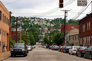
South Side Slopes is a neighborhood in Pittsburgh, Pennsylvania's South Side area. The neighborhood comprises the hills from the South Side Flats neighborhood along the Monongahela River from the Liberty Bridge (west) to beyond Josephine Street (east).

Thaw Hall is a historic academic building on the campus of the University of Pittsburgh that is a contributing property to the Schenley Farms National Historic District and has been named a Pittsburgh History and Landmarks Foundation Historic Landmark. The five-story building of stone, brick, and terra cotta was completed in 1910 in the Neoclassical Beaux-Arts style by architect Henry Hornbostel and today serves as space for a variety of academic classrooms, labs, offices, and centers. It is located between, and connected to, the university's Old Engineering Hall and Space Research Coordination Center (SRCC) along O'Hara Street in the Oakland neighborhood of Pittsburgh.

The University of Pittsburgh, commonly referred to as Pitt, is an independent, state-related, doctoral/research university in Pittsburgh, Pennsylvania, United States. For most of its history, Pitt was a private institution until it became part of the Commonwealth System of Higher Education in 1966.

The Greensburg Downtown Historic District of Greensburg, Pennsylvania, is bounded approximately by Tunnel Street, Main Street, Third Street, and Harrison Avenue. It consists of 62 buildings on 21.8 acres (8.8 ha), with the most notable buildings from the years 1872-1930. The district's oldest structure (1872) is the former Masonic Temple at 132 South Main Street. The Academy Hill Historic District is directly to the north of downtown Greensburg.
Paul Amos Batholomew (1883–1973) was an architect in Greensburg, Pennsylvania. From the beginning of his practice, he received a variety of high-profile commissions for both residential and non-residential structures, mainly in Westmoreland County, Pennsylvania. His buildings typically had historicist facades, with neoclassical or Italianate ornamentation covering a modern framework. Only in the 1950s, toward the end of his career, he created buildings that were purely modern in design. During the Great Depression, a particularly trying time for architects, he received the commission to design Norvelt, which was a new town created as part of President Roosevelt's New Deal policies.
The Keeling Coal Company (1861–1878) was a 19th-century coal mining company in Allegheny County, Pennsylvania. Its mines were located in the Pittsburgh Coalfield of western Pennsylvania.
South Side Park is an urban park in Pittsburgh. It is situated in a ravine that divides the South Side Slopes neighborhood, and extends to the location of the former Oliver Ormsby estate in Mount Oliver, Pennsylvania, Ormsby Manor.

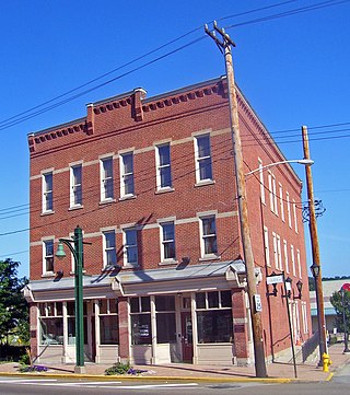
The Pittsburgh Mercantile Company Building in the South Side Flats neighborhood of Pittsburgh, Pennsylvania, United States, was built in 1907 to 1908 and functioned as the company store for the nearby Jones and Laughlin Steel Company. It is currently used as an apartment building. The structure was listed in the National Register of Historic Places in 2014.
| | This Pittsburgh-related article is a stub. You can help Wikipedia by expanding it. |